
Where is Jericho Located? - Jericho is a city located in the Chittenden County of Vermont, United States. Jericho lies between 29.5062414 Degrees North latitudes and 98.3068398 Degrees West longitudes.
Location Map of Jericho, Vermont
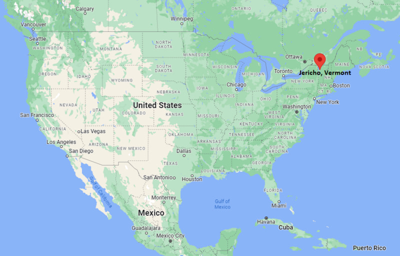
Jericho Map, Vermont, USA
Where is Jericho?: The Google Map showing the location of Jericho in the U.S. state of Vermont.
Where is Jericho Located?
Jericho is a city located in the Chittenden County of Vermont, United States. Jericho lies between 29.5062414 Degrees North latitudes and 98.3068398 Degrees West longitudes. According to 2020 U.S.census, the population of Jericho city is 1333 people and the city has a total area of 1.39 sq mi. The city has numerous parks and recreational facilities.
Most Viewed US Maps
| USA Sttae Map | USA Region Map | USA Road Map |
| USA County Map | Where is USA in World Map? | US ZIP Code Map |
| USA Time Zones Map | US State and Capitals Map | USA Physical Map |
Find 4,400+ U.S. Cities by State - Explore Their Locations and Get Detailed Information
Jericho, Vermont Quick Facts
| Property | Information |
|---|---|
| Town | Jericho |
| County | Chittenden County |
| State | Vermont |
| State Capital | Montpelier |
| US Region | Northeastern United States (New England) |
| Latitude | 44.4406° N |
| Longitude | 72.9982° W |
| Elevation | 558 ft (170 m) |
| Land Area | 35.14 sq mi |
| Water Area | 0.12 sq mi |
| Total Area | 35.26 sq mi |
| Population (latest Census year) | 5,104 (2020 Census) |
| Population Density | Approximately 145 per sq mi |
| ZIP Code | 05465 |
| Area Code | 802 |
| Time Zone Standard | Eastern Standard Time (EST, UTC−5) |
| Time Zone Daylight | Eastern Daylight Time (EDT, UTC−4) |
| Currency | US Dollar (USD) |
| FIPS Code | 50-34075 |
| Congressional District | Vermont At-large Congressional District |
Nearby Cities to Jericho, Vermont
- Essex Junction, Vermont - West - 8 mi
- Underhill, Vermont - East - 5 mi
- Richmond, Vermont - South - 9 mi
- Williston, Vermont - Southwest - 10 mi
- Burlington, Vermont - West - 15 mi
- Winooski, Vermont - West - 13 mi
- South Burlington, Vermont - Southwest - 15 mi
- Milton, Vermont - Northwest - 18 mi
- Waterbury, Vermont - Southeast - 22 mi
- St. Albans, Vermont - North - 29 mi
Driving Distances from Jericho, Vermont
| City | State | Distance (mi) | Approx. Drive Time |
|---|---|---|---|
| Underhill | Vermont | 5 | 10 minutes |
| Essex Junction | Vermont | 8 | 12 minutes |
| Richmond | Vermont | 9 | 15 minutes |
| Williston | Vermont | 10 | 15 minutes |
| Winooski | Vermont | 13 | 20 minutes |
| Burlington | Vermont | 15 | 22 minutes |
| South Burlington | Vermont | 15 | 22 minutes |
| Milton | Vermont | 18 | 25 minutes |
| Waterbury | Vermont | 22 | 30 minutes |
| St. Albans | Vermont | 29 | 35 minutes |
Transportation and Connectivity in Jericho, Vermont
| Transportation | Details |
|---|---|
| Airport Name | Patrick Leahy Burlington International Airport |
| IATA Code | BTV |
| Port | Port of Burlington (Lake Champlain) |
| Major Highways | Vermont Route 15, Vermont Route 117, Interstate 89 (nearby) |
| Train/Amtrak Service | Nearest Amtrak station is Essex Junction |
| Local Bus/Transit Service | Green Mountain Transit (nearby regional routes) |
- Vermont Route 15 is the primary roadway through Jericho, connecting the town with Burlington, Underhill, and Morrisville.
- Interstate 89 is accessible via nearby Williston and Richmond, providing regional travel throughout Vermont.
- Patrick Leahy Burlington International Airport, approximately 15 miles west, offers scheduled domestic air service.
- Amtrak's Vermonter route is available from nearby Essex Junction, providing rail service to Vermont, Massachusetts, Connecticut, New York, and Washington, D.C.
- Jericho is best known as the birthplace of Civil War leader and educator Wilson "Snowflake" Bentley, its scenic rural landscapes, and its proximity to Mount Mansfield and the Green Mountains.
What are top Places to Visit in Jericho, Vermont
| Landmark Name | Type |
|---|---|
| Old Red Mill Museum | History Museum |
| Snowflake Bentley Museum | Museum |
| Mills Riverside Park | Town Park |
| Mount Mansfield State Forest | State Forest |
| Casey's Hill | Nature Preserve |
| Jericho Country Store | Historic Landmark |
| Underhill State Park | State Park |
| Mobbs Farm | Recreation Area |
| Catamount Outdoor Family Center | Outdoor Recreation Center |
| Lake Champlain Waterfront | Scenic Destination |
Colleges and Universities in Jericho, Vermont
| Institution Name | Type | Level | Notable For |
|---|---|---|---|
| University of Vermont | Public | Research University | Medicine, engineering, agriculture, environmental sciences, business, and liberal arts |
| Saint Michael's College | Private | College | Liberal arts, education, business, biology, and international studies |
| Champlain College | Private | College | Information technology, cybersecurity, business, game design, and digital media |
| Community College of Vermont – Winooski Center | Public | Community College | Associate degrees, workforce training, healthcare, business, and transfer programs |
| Mount Mansfield Unified Union School District | Public | K–12 District | Primary and secondary public education serving Jericho and neighboring communities |
Waterbodies in Jericho, Vermont
Brown's River, Lee River, Stevens Brook, Lake Champlain, Mill Brook, Pleasant Valley Brook, Winooski River, Muddy Brook
Golf Courses in Jericho, Vermont
West Bolton Golf Club, Links at Lang Farm, Vermont National Country Club, Rocky Ridge Golf Club, Cedar Knoll Country Club, Williston Golf Club
Jericho, Vermont — Key Historical Facts
- Jericho was chartered in 1763 by New Hampshire Governor Benning Wentworth and was permanently settled in the late eighteenth century.
- The town developed around farming, sawmills, gristmills, and small industries powered by Brown's River and local streams.
- Jericho is the hometown of Wilson "Snowflake" Bentley, whose pioneering work photographing snowflakes earned international recognition.
- The historic Old Red Mill became a focal point of the community and today houses museums preserving the town's industrial and cultural heritage.
- Modern Jericho is known for its rural character, outdoor recreation, scenic Green Mountain landscapes, and proximity to Burlington while maintaining its historic New England identity.
References
Vermont Maps and Info
- Where is Barre
- Where is Bellows Falls
- Where is Bennington
- Where is Bradford
- Where is Brandon
- Where is Brattleboro
- Where is Bristol
- Where is Burlington
- Where is Castleton
- Where is Chester
- Where is Enosburg Falls
- Where is Essex Junction
- Where is Fair Haven
- Where is Hardwick
- Where is Jericho
- Where is Johnson
- Where is Lyndonville
- Where is Manchester Center
- Where is Middlebury
- Where is Milton
- Where is Montpelier
- Where is Morrisville
- Where is Newport
- Where is North Bennington
- Where is Norwich
- Where is Pittsford
- Where is Poultney
- Where is Quechee
- Where is Randolph
- Where is Richford
- Where is Rutland
- Where is Shelburne
- Where is South Barre
- Where is South Burlington
- Where is St. Albans
- Where is St. Johnsbury
- Where is Swanton
- Where is Vergennes
- Where is Wallingford
- Where is West Brattleboro
- Where is West Rutland
- Where is White River Junction
- Where is Wilder
- Where is Williamstown
- Where is Windsor
- Where is Winooski
- Where is Woodstock