
Where is Poultney Located? - Poultney is a city located in the Rutland County of Vermont, United States. Poultney lies between 32.8550377 Degrees North latitudes and 96.797592 Degrees West longitudes.
Location Map of Poultney, Vermont
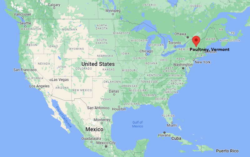
Poultney Map, Vermont, USA
Where is Poultney?: The Google Map showing the location of Poultney in the U.S. state of Vermont.
Where is Poultney Located?
Poultney is a city located in the Rutland County of Vermont, United States. Poultney lies between 32.8550377 Degrees North latitudes and 96.797592 Degrees West longitudes. According to 2020 U.S.census, the population of Poultney city is 1079 people and the city has a total area of 0.63 sq mi. The city has numerous parks and recreational facilities.
Most Viewed US Maps
| USA Sttae Map | USA Region Map | USA Road Map |
| USA County Map | Where is USA in World Map? | US ZIP Code Map |
| USA Time Zones Map | US State and Capitals Map | USA Physical Map |
Find 4,400+ U.S. Cities by State - Explore Their Locations and Get Detailed Information
Poultney, Vermont Quick Facts
| Attribute | Details |
|---|---|
| City | Poultney |
| County | Rutland County |
| State | Vermont |
| State Capital | Montpelier |
| US Region | Northeastern United States (New England Region) |
| Latitude | 43.5165° N |
| Longitude | 73.2362° W |
| Elevation | 480 ft (146 m) |
| Land Area | 44.99 sq mi |
| Water Area | 1.10 sq mi |
| Total Area | 46.09 sq mi |
| Population (2020 Census) | 3,323 |
| Population Density | Approximately 74 people per sq mi |
| ZIP Code | 05764 |
| Area Code | 802 |
| Time Zone Standard | Eastern Standard Time (EST, UTC−5) |
| Time Zone Daylight | Eastern Daylight Time (EDT, UTC−4) |
| Currency | United States Dollar (USD) |
| FIPS Code | 50-56425 |
| Congressional District | Vermont's At-Large Congressional District |
Transportation and Connectivity in Poultney
| Category | Details |
|---|---|
| Airport Name | Rutland–Southern Vermont Regional Airport |
| IATA Code | RUT |
| Port | Lake St. Catherine and regional waterways |
| Major Highways | U.S. Route 4, Vermont Route 30, Vermont Route 31 |
| Train/Amtrak Service | Amtrak service available at Rutland Station |
| Local Bus/Transit Service | Marble Valley Regional Transit District |
- U.S. Route 4 – Regional highway connecting Poultney with Rutland and New York State communities.
- Vermont Route 30 – Scenic route connecting Poultney with western Vermont destinations.
- Vermont Route 31 – Local highway providing access to surrounding rural areas.
Top Places to Visit in Poultney, Vermont
| Landmark Name | Type |
|---|---|
| Green Mountain College Historic Campus | Historic Site |
| Lake St. Catherine State Park | State Park |
| Poultney River | Natural Attraction |
| Slate Valley Museum | History Museum |
| Poultney Village Historic District | Historic District |
| East Poultney Green | Historic Area |
| Hubbarton Battlefield State Historic Site | Historic Landmark |
| Lake Bomoseen | Recreation Area |
| Green Mountain National Forest | National Forest |
| Slate Valley Trails | Outdoor Recreation Area |
Driving Distances from Poultney, Vermont to Nearby Cities
| City | State | Distance (mi) | Approx. Drive Time |
|---|---|---|---|
| Rutland | Vermont | 20 | 30 minutes |
| Manchester | Vermont | 45 | 1 hour |
| Bennington | Vermont | 65 | 1 hour 20 minutes |
| Albany | New York | 70 | 1 hour 30 minutes |
| Saratoga Springs | New York | 45 | 1 hour |
| Burlington | Vermont | 120 | 2 hours 15 minutes |
| Montpelier | Vermont | 95 | 2 hours |
| Boston | Massachusetts | 180 | 3 hours 15 minutes |
| New York City | New York | 220 | 4 hours |
| Hartford | Connecticut | 150 | 2 hours 45 minutes |
Colleges and Universities Near Poultney, Vermont
| Institution Name | Type | Level | Notable For |
|---|---|---|---|
| Green Mountain College | Private | Liberal Arts College | Environmental studies, sustainability, and liberal arts (historic institution, closed in 2019) |
| Castleton University | Public | University | Education, health sciences, arts, and sciences |
| Community College of Vermont – Rutland Center | Public | Community College | Career training, associate degrees, and flexible learning |
| College of Saint Joseph | Private | College | Education and professional studies (historic institution, closed in 2019) |
| Middlebury College | Private | Liberal Arts College | Languages, environmental studies, and international programs |
| Poultney-Mettowee School District | Public | K–12 District | Primary and secondary education |
Waterbodies in Poultney, Vermont
Lake St. Catherine, Poultney River, Lake Bomoseen, East Creek, and nearby streams and waterways of the Green Mountain region.
Golf Courses Near Poultney
Lake St. Catherine Country Club, Rutland Country Club, Green Mountain National Golf Course, Tater Hill Golf Club, and Neshobe Golf Club.
Poultney, Vermont — Key Historical Facts
- Poultney was chartered in 1761 and became one of the early settlements in western Vermont.
- The town developed around agriculture, small industries, and natural resources of the Green Mountain region.
- Poultney became known as a center of slate production because of the rich slate deposits found in the surrounding Slate Valley.
- East Poultney was an important early settlement area and includes historic buildings connected to Vermont's early history.
- Today, Poultney is known for its historic village, outdoor recreation, lakes, scenic landscapes, and connection to the Slate Valley region.
References
Vermont Maps and Info
- Where is Barre
- Where is Bellows Falls
- Where is Bennington
- Where is Bradford
- Where is Brandon
- Where is Brattleboro
- Where is Bristol
- Where is Burlington
- Where is Castleton
- Where is Chester
- Where is Enosburg Falls
- Where is Essex Junction
- Where is Fair Haven
- Where is Hardwick
- Where is Jericho
- Where is Johnson
- Where is Lyndonville
- Where is Manchester Center
- Where is Middlebury
- Where is Milton
- Where is Montpelier
- Where is Morrisville
- Where is Newport
- Where is North Bennington
- Where is Norwich
- Where is Pittsford
- Where is Poultney
- Where is Quechee
- Where is Randolph
- Where is Richford
- Where is Rutland
- Where is Shelburne
- Where is South Barre
- Where is South Burlington
- Where is St. Albans
- Where is St. Johnsbury
- Where is Swanton
- Where is Vergennes
- Where is Wallingford
- Where is West Brattleboro
- Where is West Rutland
- Where is White River Junction
- Where is Wilder
- Where is Williamstown
- Where is Windsor
- Where is Winooski
- Where is Woodstock