
Where is Bowman Located? - Bowman is a city located in the Bowman County of North Dakota, United States. Bowman lies between 46.17332 Degrees North latitudes and -103.402 Degrees West longitudes.
Location Map of Bowman, North Dakota
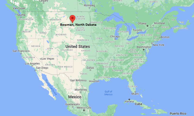
Bowman Map, North Dakota, USA
Where is Bowman?: The Google Map showing the location of Bowman in the U.S. state of North Dakota.
Where is Bowman Located?
Bowman is a city located in the Bowman County of North Dakota, United States. Bowman lies between 46.17332 Degrees North latitude and -103.402 Degrees West longitude. According to the 2020 U.S. Census, the population of Bowman city is 1,470 people and the city has a total area of 1.595 sq mi. The city has numerous parks and recreational facilities.
Most Viewed US Maps
| USA Sttae Map | USA Region Map | USA Road Map |
| USA County Map | Where is USA in World Map? | US ZIP Code Map |
| USA Time Zones Map | US State and Capitals Map | USA Physical Map |
Find 4,400+ U.S. Cities by State - Explore Their Locations and Get Detailed Information
Bowman, North Dakota Quick Facts
| Fact | Details |
|---|---|
| City | Bowman |
| County | Bowman County |
| State | North Dakota |
| State Capital | Bismarck |
| Country | United States |
| US Region | Midwest |
| Latitude | 46.17332 N |
| Longitude | -103.402 W |
| Elevation | 2,969 ft (905 m) |
| Land Area | 1.41 sq mi |
| Water Area | 0.00 sq mi |
| Total Area | 1.595 sq mi |
| Population (Census 2020) | 1,537 |
| Population Density | Approximately 1,090 per sq mi |
| ZIP Code | 58623 |
| Area Code | 701 |
| Time Zone Standard | Mountain Standard Time (MST, UTC-7) |
| Time Zone Daylight | Mountain Daylight Time (MDT, UTC-6) |
| Currency | United States Dollar (USD) |
| FIPS Code | 38-08620 |
| Congressional District | North Dakota At-Large Congressional District |
Nearby Cities and Towns to Bowman, North Dakota
- Scranton, North Dakota - 18 mi Northeast
- Rhame, North Dakota - 20 mi West
- Hettinger, North Dakota - 34 mi East
- Baker, Montana - 49 mi Northwest
- Beach, North Dakota - 63 mi North
- Marmarth, North Dakota - 37 mi Southwest
- Dickinson, North Dakota - 101 mi Northeast
- Lemmon, South Dakota - 64 mi South
- Belle Fourche, South Dakota - 123 mi South
- Miles City, Montana - 121 mi Northwest
Bowman, North Dakota Climate and Weather Overview
| Month | Avg High (°F) | Avg Low (°F) | Avg Precipitation (in) |
|---|---|---|---|
| January | 29 | 9 | 0.4 |
| April | 57 | 31 | 1.3 |
| July | 85 | 56 | 2.0 |
| October | 59 | 34 | 1.0 |
| Annual | 58 | 33 | 15.5 |
| Climate Attribute | Details |
|---|---|
| Climate Classification | Warm-Summer Humid Continental (Köppen Dfb) |
| Annual Precipitation | Approximately 15.5 inches |
| Annual Sunshine Days | About 208 days |
| Severe Weather Risk | Moderate - Winter blizzards, strong winds, thunderstorms and occasional hail |
| Annual Snowfall | Approximately 34 inches |
Driving Distances from Bowman, North Dakota
| City | State | Distance (mi) | Approx. Drive Time |
|---|---|---|---|
| Scranton | North Dakota | 18 | 20 min |
| Rhame | North Dakota | 20 | 22 min |
| Hettinger | North Dakota | 34 | 35 min |
| Marmarth | North Dakota | 37 | 40 min |
| Baker | Montana | 49 | 50 min |
| Beach | North Dakota | 63 | 1 hr |
| Lemmon | South Dakota | 64 | 1 hr 5 min |
| Dickinson | North Dakota | 101 | 1 hr 35 min |
| Miles City | Montana | 121 | 2 hr |
| Belle Fourche | South Dakota | 123 | 2 hr |
Transportation and Connectivity in Bowman, North Dakota
| Transportation | Details |
|---|---|
| Nearest Airport | Bowman Regional Airport |
| IATA Code | BWM |
| Major Highways | U.S. Route 12, U.S. Route 85, North Dakota Highway 8 |
| Rail Service | Freight rail service available in the region |
| Local Transit | Regional demand-response transportation services |
- U.S. Route 12 is the primary east-west highway connecting Bowman with communities across southern North Dakota and neighboring states.
- U.S. Route 85 provides north-south access to western North Dakota, South Dakota and Montana.
- Bowman Regional Airport supports general aviation, agricultural aviation and business travel.
- Bowman's transportation network plays an important role in supporting agriculture, energy production and regional commerce in southwestern North Dakota.
Key Landmarks and Places to Visit in Bowman, North Dakota
| Landmark | Type |
|---|---|
| Pioneer Trails Regional Museum | History Museum |
| Bowman County Fairgrounds | Event Venue |
| Bowman City Park | Community Park |
| Sunrise Butte Recreation Area | Outdoor Recreation Area |
| Bowman Golf Course | Public Golf Course |
| Roosevelt National Forest (Little Missouri National Grassland) | National Grassland |
| Sunrise Butte | Scenic Viewpoint |
| Bowman Public Library | Library |
| Bowman County Courthouse | Historic Government Building |
| Sunrise Historical Marker | Historic Site |
Colleges and Universities in Bowman, North Dakota
| Institution | Type | Level | Notable For |
|---|---|---|---|
| Dickinson State University | Public | University | Business, education, agriculture and nursing |
| Bismarck State College | Public | Community College | Energy, technology and workforce training |
| Williston State College | Public | Community College | Transfer programs and technical education |
| University of Mary | Private | University | Healthcare, business and liberal arts |
| North Dakota State University | Public | Research University | Agriculture, engineering and scientific research |
| Black Hills State University | Public | University | Business, education and natural sciences |
Waterbodies in Bowman, North Dakota
Grand River, Cedar Creek, Deep Creek, Buffalo Creek, Hay Creek, Bowman Haley Reservoir, Alkali Creek, Sand Creek, Sheep Creek, Little Missouri River.
Golf Courses in Bowman, North Dakota
Bowman Golf Course, Heart River Golf Course, Bully Pulpit Golf Course, Dickinson Country Club, Prairie West Golf Course, Hettinger Country Club, Baker Country Club, Hillsview Golf Club.
Bowman, North Dakota - Key Historical Facts
- Bowman was founded in 1907 following the arrival of the Chicago, Milwaukee, St. Paul and Pacific Railroad, which encouraged settlement in southwestern North Dakota.
- The city was named after Edward M. Bowman, a businessman and land promoter associated with railroad development.
- Agriculture, particularly wheat farming and cattle ranching, became the foundation of the local economy during the early twentieth century.
- Bowman later expanded its economy through oil and natural gas development in the Williston Basin while continuing to serve surrounding agricultural communities.
- The Pioneer Trails Regional Museum preserves the history of Native American cultures, early settlers, ranching and railroad expansion in the region.
- Today, Bowman serves as the commercial, healthcare and government center for Bowman County and is a gateway to outdoor recreation in southwestern North Dakota.
References
More North Dakota Maps & Info
- Where is Belcourt
- Where is Beulah
- Where is Bismarck
- Where is Bottineau
- Where is Bowman
- Where is Burlington
- Where is Cando
- Where is Carrington
- Where is Casselton
- Where is Cavalier
- Where is Devils Lake
- Where is Dickinson
- Where is Fargo
- Where is Fort Totten
- Where is Garrison
- Where is Grafton
- Where is Grand Forks
- Where is Grand Forks AFB
- Where is Harvey
- Where is Hazen
- Where is Hillsboro
- Where is Horace
- Where is Jamestown
- Where is Langdon
- Where is Larimore
- Where is Lisbon
- Where is Mandan
- Where is Mapleton
- Where is Mayville
- Where is Minot
- Where is Minot AFB
- Where is New Rockford
- Where is New Town
- Where is Oakes
- Where is Park River
- Where is Rolla
- Where is Rugby
- Where is Shell Valley
- Where is Stanley
- Where is Surrey
- Where is Thompson
- Where is Tioga
- Where is Valley City
- Where is Velva
- Where is Wahpeton
- Where is Washburn
- Where is Watford City
- Where is West Fargo
- Where is Williston