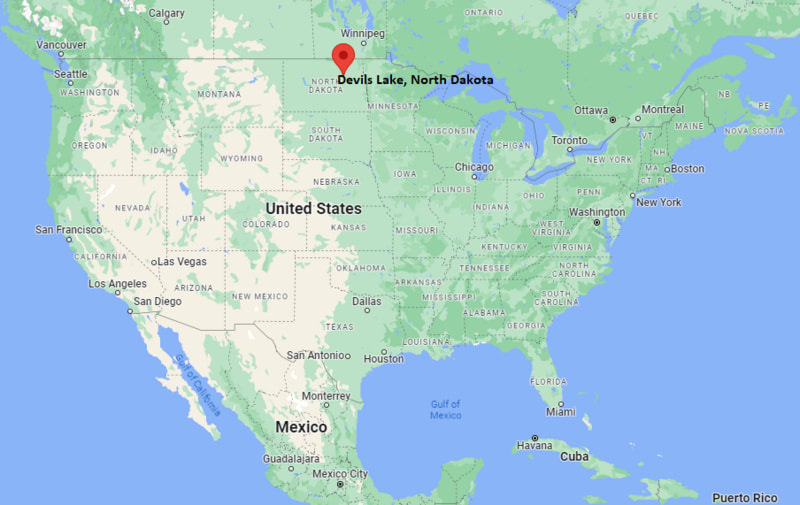
Where is Devils Lake Located? - Devils Lake is a city located in the Ramsey County of North Dakota, United States. Devils Lake lies between 43.9747838 Degrees North latitudes and 75.9107565 Degrees West longitudes.
Location Map of Devils Lake, North Dakota
Devils Lake Map, North Dakota, USA
Where is Devils Lake?: The Google Map showing the location of Devils Lake in the U.S. state of North Dakota.
Where is Devils Lake Located?
Devils Lake is a city located in the Ramsey County of North Dakota, United States. Devils Lake lies between 43.9747838 Degrees North latitudes and 75.9107565 Degrees West longitudes. According to 2020 U.S.census, the population of Devils Lake city is 7192 people and the city has a total area of 6.92 sq mi. The city has numerous parks and recreational facilities.
Devils Lake, North Dakota Climate and Weather Overview
Month
Avg High (°F)
Avg Low (°F)
Avg Rainfall (in)
January
19
1
0.6
April
53
30
1.3
July
82
57
2.8
October
55
33
1.3
Annual
52
31
18.5
Climate Attribute
Details
Climate Classification (Köppen)
Warm-Summer Humid Continental (Dfb)
Annual Rainfall
About 18.5 inches
Annual Sunshine Days
Approximately 201 days
Hurricane/Tornado Risk
No hurricane risk; low tornado risk
Snowfall
About 39 inches annually
Driving Distances from Devils Lake, North Dakota
City
State
Distance (mi)
Approx. Drive Time
Fort Totten
North Dakota
12
15 min
Crary
North Dakota
18
20 min
Minnewaukan
North Dakota
25
30 min
Lakota
North Dakota
28
32 min
Rugby
North Dakota
63
1 hr
Cando
North Dakota
66
1 hr 5 min
New Rockford
North Dakota
73
1 hr 15 min
Grafton
North Dakota
81
1 hr 20 min
Grand Forks
North Dakota
92
1 hr 30 min
Jamestown
North Dakota
106
1 hr 45 min
Transportation and Connectivity in Devils Lake, North Dakota
Transportation
Details
Airport Name
Devils Lake Regional Airport
IATA Code
DVL
Port
No commercial port
Major Highways
US Highway 2, US Highway 281, North Dakota Highway 20, North Dakota Highway 19
Train/Amtrak Service
Amtrak Empire Builder station in Devils Lake
Local Bus/Transit Service
Local demand-response transit and Jefferson Lines regional bus service
US Highway 2 is the primary east-west highway connecting Devils Lake with Grand Forks, Minot, and other northern North Dakota communities.
US Highway 281 provides north-south access to Carrington, Jamestown, and the Canadian border.
The Amtrak Empire Builder serves Devils Lake with passenger rail connections to Chicago, Minneapolis-St. Paul, Seattle, and Portland.
Devils Lake Regional Airport supports general aviation and scheduled regional air service.
Key Landmarks and Places to Visit in Devils Lake, North Dakota
Landmark Name
Type
Grahams Island State Park
State Park
Devils Lake State Recreation Area
Recreation Area
Fort Totten State Historic Site
Historic Site
Spirit Lake Casino & Resort
Casino & Resort
Ruger Park
Community Park
Creel Bay Golf Course
Golf Course
Lake Region Heritage Center
History Museum
Black Tiger Bay State Recreation Area
Outdoor Recreation Area
Roosevelt Park
City Park
Devils Lake Downtown Historic District
Historic District
Colleges and Universities in Devils Lake, North Dakota
Institution Name
Type
Level
Notable For
Lake Region State College
Public
Community College
Academic transfer, career, and workforce programs
University of North Dakota
Public
University
Research, aviation, engineering, and health sciences
Mayville State University
Public
University
Teacher education and liberal arts
Dakota College at Bottineau
Public
Community College
Natural resources and career education
North Dakota State University
Public
University
Agriculture, engineering, and research
Waterbodies in Devils Lake, North Dakota
Devils Lake, East Devils Lake, West Bay, Creel Bay, Sixmile Bay, Mission Bay, Pelican Lake, Stump Lake
Golf Courses in Devils Lake, North Dakota
Creel Bay Golf Course, Cando Golf Club, Lakota Municipal Golf Course, Rugby Golf Club, Bottineau Country Club, Grafton Country Club
Devils Lake, North Dakota - Key Historical Facts
Devils Lake was founded in 1882 following the arrival of the Great Northern Railway, which established the community as an important transportation and trade center in northeastern North Dakota.
The city takes its name from the nearby natural lake, known to the Spirit Lake Dakota Nation as Mni Wakan, meaning "Spirit Lake."
Agriculture, rail transportation, and tourism have long been central to the local economy, with fishing and outdoor recreation attracting visitors from across the Midwest.
During the late 20th and early 21st centuries, rising lake levels significantly reshaped the surrounding landscape, infrastructure, and land use.
Devils Lake has developed into one of North Dakota's premier destinations for walleye fishing, boating, hunting, and wildlife observation.
Today, the city serves as the commercial, educational, and recreational hub of the Lake Region while maintaining strong ties to the Spirit Lake Nation and the area's agricultural heritage.