Written and Fact-checked by Whereig Editors | Updated On: May 31, 2026
Map of Ramsey County - Ramsey County is a county located in the U.S. state of North Dakota. Ramsey County Map showing cities, highways, important places and water bodies. Get Where is Ramsey County located in the map, major cities in Ramsey county, population, areas, and places of interest.
Map of Ramsey County, North Dakota
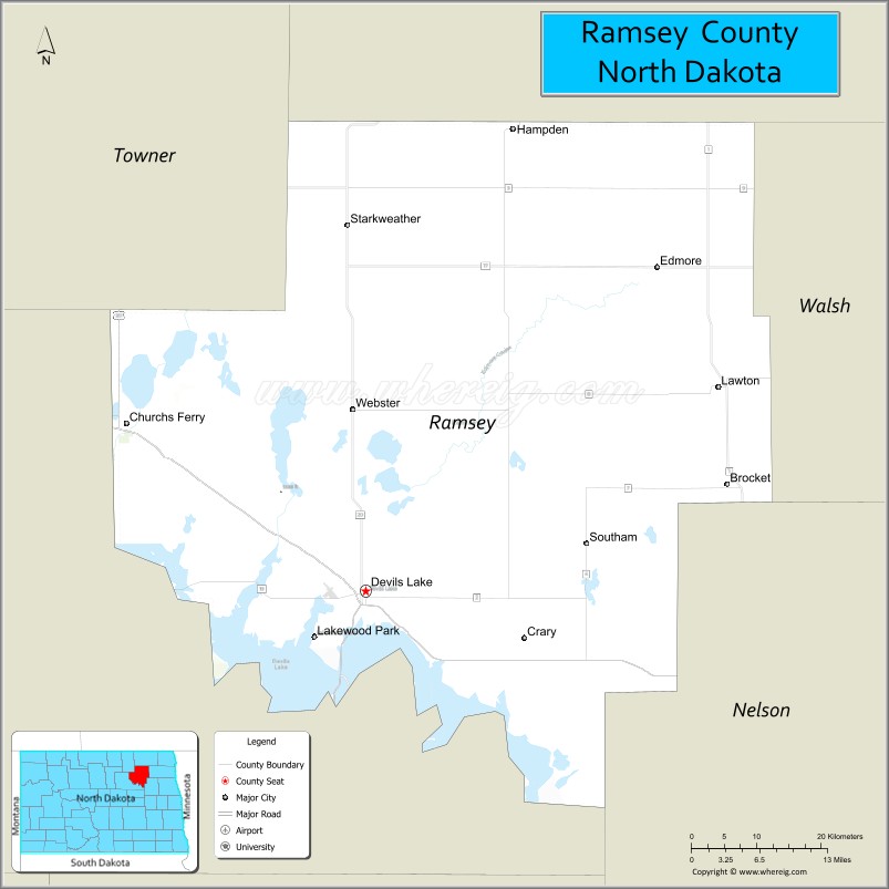
About Ramsey County Map, North Dakota: The map showing the county boundary, county seat, major cities, highways, water bodies and neighbouring counties.
More North Dakota Maps & Info
About Ramsey County, North Dakota
Ramsey County is a county located in the U.S. state of North Dakota. It's county seat is Devils Lake. As per 2020 census, the population of Ramsey County is 11572 people and population density is square miles. According to the United States Census Bureau, the county has a total area of 1,186 sq mi (3,072 km2). Ramsey County was established on 1873.
Ramsey County Facts
| Continent | North America |
| Country | United States |
| State | North Dakota |
| County Seat | Devils Lake |
| Largest City/Town | Devils Lake |
| Established | 1873 |
| Total Area | 1,294.0 sq mi (3,351.5 sq km) |
| Land Area | 1,186.0 sq mi (3,071.7 sq km) |
| Water Area | 108.0 sq mi (279.7 sq km) |
| Population | 11,605 (Census 2020) |
| Population Density | 9.8 people per sq mi |
| Time Zone | Central Time Zone |
| Major Highways | US Highway 2, US Highway 281, North Dakota Highway 19, North Dakota Highway 20, North Dakota Highway 57 |
| Major Rivers | Mauvais Coulee, Big Coulee |
| Neighboring Counties | Towner, Benson, Eddy, Nelson, Walsh, Cavalier |
| Famous For | Devils Lake, world-class fishing, Spirit Lake Nation, wildlife refuges, and outdoor recreation |
| Top Attractions | Devils Lake, Grahams Island State Park, White Horse Hill National Game Preserve, Spirit Lake Casino & Resort, Devils Lake State Recreation Area |
| Official Website | Official Website |
About Ramsey County, North Dakota
Ramsey County is located in northeastern North Dakota and was established in 1873. The county seat and largest city is Devils Lake. The county is centered around Devils Lake, the largest natural body of water in North Dakota, making it a major destination for fishing, boating, birdwatching, and outdoor recreation. Agriculture and tourism are important contributors to the local economy.
Cities and Towns in Ramsey County, North Dakota
| City/Town | Population (Census 2020) | Latitude & Longitude |
|---|---|---|
| Devils Lake (county seat) | 7,192 | 48.1128°N, 98.8651°W |
| Edmore | 119 | 48.4122°N, 98.4629°W |
| Lawton | 15 | 48.3125°N, 98.3737°W |
| Crary | 113 | 48.0842°N, 98.6181°W |
| Churchs Ferry | 12 | 48.2695°N, 99.2035°W |
| Starkweather | 107 | 48.4520°N, 98.8693°W |
| Brocket | 38 | 47.9698°N, 98.3540°W |
| Webster | 24 | 48.3073°N, 98.7245°W |
| Minnewaukan | 224 | 48.0705°N, 99.2526°W |
| Southam (CDP) | 18 | 48.2251°N, 98.9964°W |
Best Golf Courses in Ramsey County, North Dakota
| Golf Course | Location | Latitude & Longitude |
|---|---|---|
| Creel Bay Golf Course | Devils Lake | 48.1367°N, 98.9145°W |
| Devils Lake Town & Country Club | Devils Lake | 48.0958°N, 98.8897°W |
| Minnewaukan Golf Course | Minnewaukan | 48.0698°N, 99.2605°W |
What are Major Roads and Highways in Ramsey County
Major highways connect the county to nearby regions and cities.
- US Highway 2 - major east-west corridor connecting Devils Lake with Grand Forks, Rugby, and Minot
- US Highway 281 - north-south route linking Devils Lake with Carrington and the Canadian border region
- North Dakota Highway 19 - serves eastern and southern portions of the county
- North Dakota Highway 20 - connects Devils Lake with neighboring counties and recreational areas
- North Dakota Highway 57 - provides access to Minnewaukan and western lakeshore communities
Neighboring Counties of Ramsey County
- Towner County (north)
- Cavalier County (northeast)
- Walsh County (east)
- Nelson County (southeast)
- Eddy County (south)
- Benson County (west)
What are Top Attractions in Ramsey County, North Dakota
The county offers a mix of natural and cultural attractions.
| Main Sight Name | City | Famous For |
|---|---|---|
| Devils Lake | Devils Lake | World-famous fishing, boating, and water recreation |
| Grahams Island State Park | Near Devils Lake | Camping, fishing, trails, and lake access |
| White Horse Hill National Game Preserve | Near Devils Lake | Bison, elk, prairie landscapes, and wildlife viewing |
| Spirit Lake Casino & Resort | St. Michael Area | Gaming, entertainment, and lodging |
| Devils Lake State Recreation Area | Devils Lake | Camping and outdoor recreation |
| Creel Bay Golf Course | Devils Lake | Golf and scenic lake views |
| Devils Lake Town & Country Club | Devils Lake | Golf and community events |
| Spirit Lake Nation Cultural Sites | Countywide | Native American history and heritage |
| Black Tiger Bay Recreation Area | Devils Lake | Fishing access and boating |
| Lake Region Heritage Center | Devils Lake | Regional history exhibits and archives |
| Minnewaukan Flats | Minnewaukan | Birdwatching and wildlife habitat |
| Wood Lake Wildlife Area | Countywide | Hunting and nature observation |
Distance from Ramsey County to Nearby Cities
The following distances are measured by road (driving).
- Devils Lake to Minnewaukan (Ramsey County), North Dakota - 27 mi (43 km)
- Devils Lake to Crary (Ramsey County), North Dakota - 12 mi (19 km)
- Devils Lake to Starkweather (Ramsey County), North Dakota - 24 mi (39 km)
- Devils Lake to Rugby (Pierce County), North Dakota - 58 mi (93 km)
- Devils Lake to Lakota (Nelson County), North Dakota - 32 mi (51 km)
- Devils Lake to Cando (Towner County), North Dakota - 35 mi (56 km)
- Devils Lake to New Rockford (Eddy County), North Dakota - 47 mi (76 km)
- Devils Lake to Langdon (Cavalier County), North Dakota - 52 mi (84 km)
- Devils Lake to Grafton (Walsh County), North Dakota - 63 mi (101 km)
- Devils Lake to Grand Forks (Grand Forks County), North Dakota - 91 mi (146 km)
- Devils Lake to Carrington (Foster County), North Dakota - 65 mi (105 km)
- Devils Lake to Jamestown (Stutsman County), North Dakota - 99 mi (159 km)
- Devils Lake to Minot (Ward County), North Dakota - 118 mi (190 km)
- Devils Lake to Fargo (Cass County), North Dakota - 172 mi (277 km)
- Devils Lake to Bismarck (Burleigh County), North Dakota - 170 mi (274 km)
References
- QuickFacts - U.S. Census Bureau
- United States Census Bureau
- United States Geological Survey (USGS)
- National Geodetic Survey
- Official County Website
- Adams County Map
- Barnes County Map
- Benson County Map
- Billings County Map
- Bottineau County Map
- Bowman County Map
- Burke County Map
- Burleigh County Map
- Cass County Map
- Cavalier County Map
- Dickey County Map
- Divide County Map
- Dunn County Map
- Eddy County Map
- Emmons County Map
- Foster County Map
- Golden Valley County Map
- Grand Forks County Map
- Grant County Map
- Griggs County Map
- Hettinger County Map
- Kidder County Map
- LaMoure County Map
- Logan County Map
- McHenry County Map
- McKenzie County Map
- McLean County Map
- McIntosh County Map
- Mercer County Map
- Morton County Map
- Mountrail County Map
- Nelson County Map
- Oliver County Map
- Pembina County Map
- Pierce County Map
- Ramsey County Map
- Ransom County Map
- Renville County Map
- Richland County Map
- Rolette County Map
- Sargent County Map
- Sheridan County Map
- Sioux County Map
- Slope County Map
- Stark County Map
- Steele County Map
- Stutsman County Map
- Towner County Map
- Traill County Map
- Walsh County Map
- Ward County Map
- Wells County Map
- Williams County Map
- Alabama Counties
- Alaska boroughs
- Arizona Counties
- Arkansas Counties
- California County Map
- Colorado Counties
- Connecticut Counties
- Delaware Counties
- Florida County Map
- Georgia County Map
- Hawaii Counties
- Idaho Counties
- Illinois Counties
- Indiana Counties
- Iowa Counties
- Kansas Counties
- Kentucky Counties
- Louisiana Counties
- Maine Counties
- Maryland Counties
- Massachusetts Counties
- Michigan County Map
- Minnesota Counties
- Mississippi Counties
- Missouri Counties
- Montana Counties
- Nebraska Counties
- Nevada Counties
- New York Counties
- New Hampshire Counties
- New Jersey Counties
- New Mexico Counties
- North Carolina Counties
- North Dakota Counties
- Ohio County Map
- Oklahoma Counties
- Oregon Counties
- Pennsylvania Counties
- Rhode Island Counties
- South Carolina Counties
- South Dakota Counties
- Map of Tennessee
- Texas County Map
- Utah Counties
- Vermont Counties
- Virginia Counties
- Washington Counties
- West Virginia Counties
- Wisconsin Counties
- Wyoming Counties