Written and Fact-checked by Whereig Editors | Updated On: May 31, 2026
Map of Walsh County - Walsh County is a county located in the U.S. state of North Dakota. Walsh County Map showing cities, highways, important places and water bodies. Get Where is Walsh County located in the map, major cities in Walsh county, population, areas, and places of interest.
Map of Walsh County, North Dakota
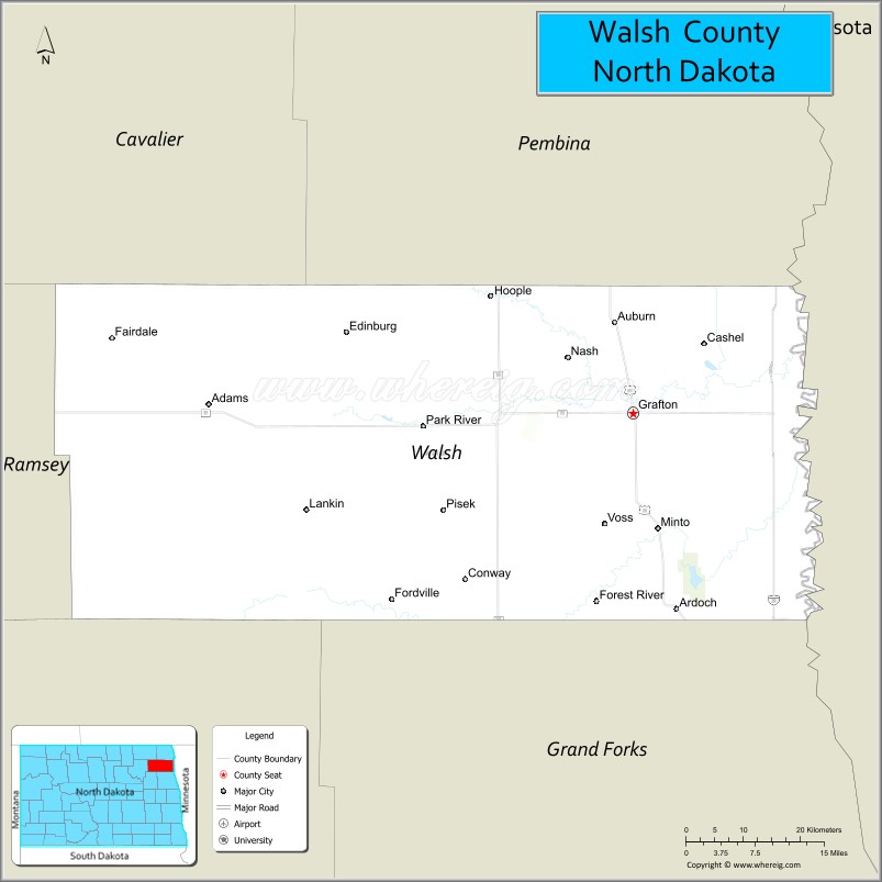
About Walsh County Map, North Dakota: The map showing the county boundary, county seat, major cities, highways, water bodies and neighbouring counties.
More North Dakota Maps & Info
About Walsh County, North Dakota
Walsh County is a county located in the U.S. state of North Dakota. It's county seat is Grafton. As per 2020 census, the population of Walsh County is 10469 people and population density is square miles. According to the United States Census Bureau, the county has a total area of 1,282 sq mi (3,320 km2). Walsh County was established on 1881.
Walsh County Facts
| Continent | North America |
| Country | United States |
| State | North Dakota |
| County Seat | Grafton |
| Largest City/Town | Grafton |
| Established | 1881 |
| Total Area | 1,294.0 sq mi (3,351.5 sq km) |
| Land Area | 1,282.0 sq mi (3,319.4 sq km) |
| Water Area | 12.0 sq mi (31.1 sq km) |
| Population | 10,563 (Census 2020) |
| Population Density | 8.2 people per sq mi |
| Time Zone | Central Time Zone |
| Major Highways | US Highway 81, North Dakota Highway 17, North Dakota Highway 18, North Dakota Highway 32, North Dakota Highway 54 |
| Major Rivers | Red River of the North, Park River, Forest River |
| Neighboring Counties | Pembina County, Cavalier County, Ramsey County, Grand Forks County, Nelson County |
| Famous For | Grafton State School, fertile Red River Valley farmland, Icelandic heritage, and outdoor recreation |
| Top Attractions | Heritage Village, Leistikow Park, Walsh County Historical Museum, Park River Bible Camp Area, and Red River Valley scenery |
| Official Website | Official Website |
About Walsh County, North Dakota
Walsh County is located in northeastern North Dakota and was established in 1881. The county seat and largest city is Grafton. Situated within the fertile Red River Valley, the county is known for agriculture, strong Scandinavian heritage, and numerous small communities. The Red River of the North forms part of the county's eastern border with Minnesota.
Cities and Towns in Walsh County, North Dakota
| City/Town | Population (Census 2020) | Latitude & Longitude |
|---|---|---|
| Grafton (county seat) | 4,170 | 48.4122°N, 97.4109°W |
| Park River | 1,364 | 48.3986°N, 97.7415°W |
| Fordville | 196 | 48.2167°N, 97.7979°W |
| Hoople | 242 | 48.5419°N, 97.6387°W |
| Lankin | 97 | 48.3136°N, 97.9248°W |
| Minto | 604 | 48.2869°N, 97.3701°W |
| Adams | 127 | 48.4181°N, 98.0754°W |
| Conway | 17 | 48.3914°N, 97.6895°W |
| Edinburg | 178 | 48.4925°N, 97.8631°W |
| Fairdale | 38 | 48.4911°N, 98.2125°W |
| Forest River | 125 | 48.2108°N, 97.4745°W |
| Galesburg | 108 | 48.4047°N, 97.7459°W |
| Mekinock | 72 | 48.3653°N, 97.2758°W |
| Nash | 32 | 48.4731°N, 97.5304°W |
| Pisek | 98 | 48.3081°N, 97.7384°W |
| Veseleyville (CDP) | 15 | 48.4687°N, 97.7603°W |
Best Golf Courses in Walsh County, North Dakota
| Golf Course | Location | Latitude & Longitude |
|---|---|---|
| Grafton Country Club | Grafton | 48.4251°N, 97.4258°W |
| Park River Country Club | Park River | 48.4048°N, 97.7547°W |
| Forest River Golf Course | Forest River | 48.2143°N, 97.4857°W |
What are Major Roads and Highways in Walsh County
Major highways connect the county to nearby regions and cities.
- US Highway 81 - major north-south route connecting Grafton with Grand Forks and Pembina
- North Dakota Highway 17 - east-west route across northern North Dakota serving Grafton and Park River
- North Dakota Highway 18 - north-south route connecting several western county communities
- North Dakota Highway 32 - serves eastern Walsh County and links communities to Grand Forks County
- North Dakota Highway 54 - provides regional access through central portions of the county
Neighboring Counties of Walsh County
- Pembina County (north)
- Cavalier County (west)
- Ramsey County (southwest)
- Nelson County (south)
- Grand Forks County (southeast)
- Marshall County, Minnesota (east)
- Polk County, Minnesota (east)
What are Top Attractions in Walsh County, North Dakota
The county offers a mix of natural and cultural attractions.
| Main Sight Name | City | Famous For |
|---|---|---|
| Heritage Village | Grafton | Historic pioneer buildings and local history exhibits |
| Leistikow Park | Grafton | Camping, trails, fishing, and recreation |
| Walsh County Historical Museum | Grafton | County history and cultural exhibits |
| Grafton Country Club | Grafton | Golf and outdoor recreation |
| Park River Bible Camp Area | Park River | Outdoor activities and community events |
| Park River | Park River | Fishing, wildlife viewing, and natural scenery |
| Forest River Recreation Area | Forest River | Nature observation and outdoor activities |
| Icelandic State Heritage Sites | Countywide | Scandinavian cultural heritage and history |
| Red River Valley Scenic Drives | Countywide | Prairie landscapes and agricultural scenery |
| Minto Community Park | Minto | Family recreation and local events |
| Hoople Community Center | Hoople | Community gatherings and local heritage |
| Prairie Wetlands Area | Countywide | Birdwatching and wildlife habitat |
Distance from Walsh County to Nearby Cities
The following distances are measured by road (driving).
- Grafton to Park River (Walsh County), North Dakota - 20 mi (32 km)
- Grafton to Minto (Walsh County), North Dakota - 10 mi (16 km)
- Grafton to Hoople (Walsh County), North Dakota - 15 mi (24 km)
- Grafton to Fordville (Walsh County), North Dakota - 24 mi (39 km)
- Grafton to Cavalier (Pembina County), North Dakota - 33 mi (53 km)
- Grafton to Grand Forks (Grand Forks County), North Dakota - 42 mi (68 km)
- Grafton to Devils Lake (Ramsey County), North Dakota - 63 mi (101 km)
- Grafton to Langdon (Cavalier County), North Dakota - 56 mi (90 km)
- Grafton to Hillsboro (Traill County), North Dakota - 69 mi (111 km)
- Grafton to Fargo (Cass County), North Dakota - 101 mi (163 km)
- Grafton to Wahpeton (Richland County), North Dakota - 158 mi (254 km)
- Grafton to Jamestown (Stutsman County), North Dakota - 171 mi (275 km)
- Grafton to Bismarck (Burleigh County), North Dakota - 221 mi (356 km)
- Grafton to Minot (Ward County), North Dakota - 193 mi (311 km)
- Grafton to Winnipeg, Manitoba - 89 mi (143 km)
References
- QuickFacts - Walsh County, North Dakota
- United States Census Bureau
- United States Geological Survey (USGS)
- National Geodetic Survey
- Official County Website
- Adams County Map
- Barnes County Map
- Benson County Map
- Billings County Map
- Bottineau County Map
- Bowman County Map
- Burke County Map
- Burleigh County Map
- Cass County Map
- Cavalier County Map
- Dickey County Map
- Divide County Map
- Dunn County Map
- Eddy County Map
- Emmons County Map
- Foster County Map
- Golden Valley County Map
- Grand Forks County Map
- Grant County Map
- Griggs County Map
- Hettinger County Map
- Kidder County Map
- LaMoure County Map
- Logan County Map
- McHenry County Map
- McKenzie County Map
- McLean County Map
- McIntosh County Map
- Mercer County Map
- Morton County Map
- Mountrail County Map
- Nelson County Map
- Oliver County Map
- Pembina County Map
- Pierce County Map
- Ramsey County Map
- Ransom County Map
- Renville County Map
- Richland County Map
- Rolette County Map
- Sargent County Map
- Sheridan County Map
- Sioux County Map
- Slope County Map
- Stark County Map
- Steele County Map
- Stutsman County Map
- Towner County Map
- Traill County Map
- Walsh County Map
- Ward County Map
- Wells County Map
- Williams County Map
- Alabama Counties
- Alaska boroughs
- Arizona Counties
- Arkansas Counties
- California County Map
- Colorado Counties
- Connecticut Counties
- Delaware Counties
- Florida County Map
- Georgia County Map
- Hawaii Counties
- Idaho Counties
- Illinois Counties
- Indiana Counties
- Iowa Counties
- Kansas Counties
- Kentucky Counties
- Louisiana Counties
- Maine Counties
- Maryland Counties
- Massachusetts Counties
- Michigan County Map
- Minnesota Counties
- Mississippi Counties
- Missouri Counties
- Montana Counties
- Nebraska Counties
- Nevada Counties
- New York Counties
- New Hampshire Counties
- New Jersey Counties
- New Mexico Counties
- North Carolina Counties
- North Dakota Counties
- Ohio County Map
- Oklahoma Counties
- Oregon Counties
- Pennsylvania Counties
- Rhode Island Counties
- South Carolina Counties
- South Dakota Counties
- Map of Tennessee
- Texas County Map
- Utah Counties
- Vermont Counties
- Virginia Counties
- Washington Counties
- West Virginia Counties
- Wisconsin Counties
- Wyoming Counties