Map of Bates County - Bates County is a county located in the U.S. state of Missouri. Bates County Map showing cities, highways, important places and water bodies. Get Where is Bates County located in the map, major cities in Bates county, population, areas, and places of interest.
Map of Bates County, Missouri
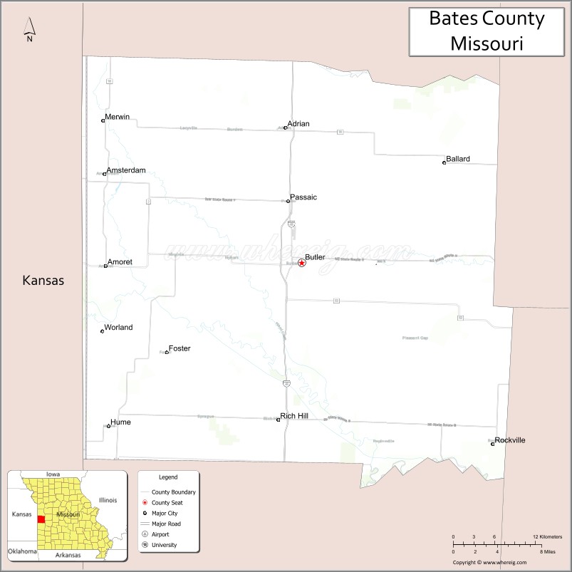
About Bates County Map, Missouri: The map showing the county boundary, county seat, major cities, highways, water bodies and neighbouring counties.
Related Missouri Maps & Info
Bates County, Missouri
Bates County is a county located in the U.S. state of Missouri. It's county seat is Butler. As per 2020 census, the population of Bates County is 16105 people and population density is square miles. According to the United States Census Bureau, the county has a total area of 848 sq mi (2,196 km2). Bates County was established on 1841.
Bates County Facts
| Continent | North America |
| Country | United States |
| State | Missouri |
| County Seat | Butler |
| Largest City/Town | Butler |
| Established | 1841 |
| Total Area | 851 sq mi (2,204 sq km) |
| Land Area | 837 sq mi (2,168 sq km) |
| Water Area | 14 sq mi (36 sq km) |
| Population | 16,042 (Census 2020) |
| Population Density | 19.2 people per sq mi |
| Time Zone | Central Time Zone (CST/CDT) |
| Major Highways | Interstate 49, U.S. Route 71, Missouri Route 52 |
| Major Rivers | Marais des Cygnes River, Osage River nearby region |
| Neighboring Counties | Cass County, Henry County, St. Clair County, Vernon County |
| Famous For | Prairie agriculture, Civil War history, Katy Trail nearby region, and rural Missouri landscapes |
| Top Attractions | Bates County Museum, Butler historic square, Four Rivers Conservation Area nearby region, and Truman Reservoir nearby area |
| Official Website | Official Website |
About Bates County
Bates County is located in west-central Missouri in the central United States and was established in 1841. The county seat and largest city is Butler. The county is known for its agricultural economy, prairie landscapes, Civil War history, and outdoor recreation opportunities in western Missouri.
Cities and Towns in Bates County, Missouri
| City/Town | Population (Census 2020) | Latitude & Longitude |
|---|---|---|
| Butler (county seat) | 4,220 | 38.2584°N, 94.3305°W |
| Adrian | 1,677 | 38.3981°N, 94.3513°W |
| Rich Hill | 1,293 | 38.0967°N, 94.3611°W |
| Drexel | 928 | 38.4795°N, 94.6088°W |
| Amsterdam | 211 | 38.3508°N, 94.5886°W |
| Hume | 329 | 38.0900°N, 94.5836°W |
What are the Golf Courses in Bates County
| Golf Course | Location | Latitude & Longitude |
|---|---|---|
| Butler Country Club | Butler | 38.2647°N, 94.3371°W |
| Rich Hill Golf & Recreation Area | Rich Hill | 38.1034°N, 94.3679°W |
Major Roads and Highways in Bates County
Major highways connect the county with western Missouri communities and Kansas City regional areas.
- Interstate 49 - major north-south interstate through western Missouri
- U.S. Route 71 - regional transportation corridor across Missouri
- Missouri Route 52 - important east-west route through agricultural communities
What are Neighboring Counties of Bates County
- Cass County (north)
- Henry County (east)
- St. Clair County (southeast)
- Vernon County (south)
What Are the Top Attractions in Bates County
The county offers a mix of prairie scenery, local history, and outdoor recreation opportunities.
- Bates County Museum - exhibits on pioneer history, Civil War heritage, and agriculture
- Butler Historic Square - downtown district with shops, restaurants, and historic buildings
- Four Rivers Conservation Area nearby region - wetlands, birdwatching, fishing, and hiking
- Truman Reservoir nearby area - boating, fishing, and camping destination
- Adrian Prairie Landscapes - scenic rural countryside and farmland views
- Rich Hill Mining Heritage Sites - local history attractions connected to coal mining
- West-Central Missouri Scenic Drives - rolling prairie and agricultural landscapes
- Marais des Cygnes River Recreation Areas - wildlife viewing and fishing opportunities
- Community Festivals in Butler - fairs, rodeos, and seasonal events
- Historic Rural Churches and Schoolhouses - preserved architecture from early settlement years
What Is the Distance from Bates County to Nearby Cities
The following distances are measured by road (driving).
- Butler to Kansas City (Jackson County), Missouri - 67 mi (108 km)
- Butler to Springfield (Greene County), Missouri - 133 mi (214 km)
- Butler to Nevada (Vernon County), Missouri - 34 mi (55 km)
- Butler to Clinton (Henry County), Missouri - 39 mi (63 km)
- Butler to Adrian (Bates County), Missouri - 11 mi (18 km)
- Butler to Rich Hill (Bates County), Missouri - 21 mi (34 km)
- Butler to Wichita (Sedgwick County), Kansas - 204 mi (328 km)
- Butler to Columbia (Boone County), Missouri - 162 mi (261 km)
- Butler to Saint Louis (St. Louis City), Missouri - 278 mi (447 km)
- Butler to Tulsa (Tulsa County), Oklahoma - 199 mi (320 km)
- Butler to Little Rock (Pulaski County), Arkansas - 339 mi (546 km)
- Butler to Denver (Denver County), Colorado - 608 mi (978 km)
- Butler to Minneapolis (Hennepin County), Minnesota - 506 mi (814 km)
FAQs about Bates County
Bates County is located in west-central Missouri near the Kansas border.
Bates County had a population of 16,042 according to the 2020 United States Census.
Bates County is known for prairie agriculture, Civil War history, rural landscapes, and outdoor recreation.
The county is served by Interstate 49, U.S. Route 71, and Missouri Route 52.
Yes, Bates County includes golf facilities such as Butler Country Club and Rich Hill Golf & Recreation Area.
References
- QuickFacts - U.S. Census Bureau
- United States Census Bureau
- United States Geological Survey (USGS)
- National Geodetic Survey
- Official Website
- Adair County Map
- Andrew County Map
- Atchison County Map
- Audrain County Map
- Barry County Map
- Barton County Map
- Bates County Map
- Benton County Map
- Bollinger County Map
- Boone County Map
- Buchanan County Map
- Butler County Map
- Caldwell County Map
- Callaway County Map
- Camden County Map
- Cape Girardeau County Map
- Carroll County Map
- Carter County Map
- Cass County Map
- Cedar County Map
- Chariton County Map
- Christian County Map
- Clark County Map
- Clay County Map
- Clinton County Map
- Cole County Map
- Cooper County Map
- Crawford County Map
- Dade County Map
- Dallas County Map
- Daviess County Map
- DeKalb County Map
- Dent County Map
- Douglas County Map
- Dunklin County Map
- Franklin County Map
- Gasconade County Map
- Gentry County Map
- Greene County Map
- Grundy County Map
- Harrison County Map
- Henry County Map
- Hickory County Map
- Holt County Map
- Howard County Map
- Howell County Map
- Iron County Map
- Jackson County Map
- Jasper County Map
- Jefferson County Map
- Johnson County Map
- Knox County Map
- Laclede County Map
- Lafayette County Map
- Lawrence County Map
- Lewis County Map
- Lincoln County Map
- Linn County Map
- Livingston County Map
- McDonald County Map
- Macon County Map
- Madison County Map
- Maries County Map
- Marion County Map
- Mercer County Map
- Miller County Map
- Mississippi County Map
- Moniteau County Map
- Monroe County Map
- Montgomery County Map
- Morgan County Map
- New Madrid County Map
- Newton County Map
- Nodaway County Map
- Oregon County Map
- Osage County Map
- Ozark County Map
- Pemiscot County Map
- Perry County Map
- Pettis County Map
- Phelps County Map
- Pike County Map
- Platte County Map
- Polk County Map
- Pulaski County Map
- Putnam County Map
- Ralls County Map
- Randolph County Map
- Ray County Map
- Reynolds County Map
- Ripley County Map
- St Charles County Map
- St Clair County Map
- Ste Genevieve County Map
- St Francois County Map
- St Louis County Map
- Saline County Map
- Schuyler County Map
- Scotland County Map
- Scott County Map
- Shannon County Map
- Shelby County Map
- Stoddard County Map
- Stone County Map
- Sullivan County Map
- Taney County Map
- Texas County Map
- Vernon County Map
- Warren County Map
- Washington County Map
- Wayne County Map
- Webster County Map
- Worth County Map
- Wright County Map
- St Louis County Map
- Alabama Counties
- Alaska boroughs
- Arizona Counties
- Arkansas Counties
- California County Map
- Colorado Counties
- Connecticut Counties
- Delaware Counties
- Florida County Map
- Georgia County Map
- Hawaii Counties
- Idaho Counties
- Illinois Counties
- Indiana Counties
- Iowa Counties
- Kansas Counties
- Kentucky Counties
- Louisiana Counties
- Maine Counties
- Maryland Counties
- Massachusetts Counties
- Michigan County Map
- Minnesota Counties
- Mississippi Counties
- Missouri Counties
- Montana Counties
- Nebraska Counties
- Nevada Counties
- New York Counties
- New Hampshire Counties
- New Jersey Counties
- New Mexico Counties
- North Carolina Counties
- North Dakota Counties
- Ohio County Map
- Oklahoma Counties
- Oregon Counties
- Pennsylvania Counties
- Rhode Island Counties
- South Carolina Counties
- South Dakota Counties
- Map of Tennessee
- Texas County Map
- Utah Counties
- Vermont Counties
- Virginia Counties
- Washington Counties
- West Virginia Counties
- Wisconsin Counties
- Wyoming Counties