Map of Cedar County - Cedar County is a county located in the U.S. state of Missouri. Cedar County Map showing cities, highways, important places and water bodies. Get Where is Cedar County located in the map, major cities in Cedar county, population, areas, and places of interest.
Map of Cedar County, Missouri
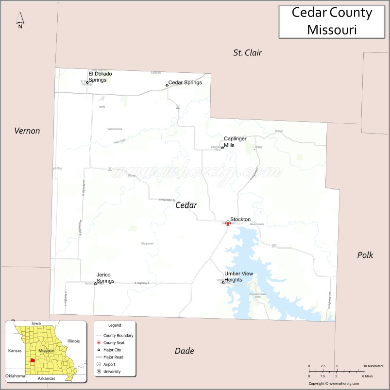
About Cedar County Map, Missouri: The map showing the county boundary, county seat, major cities, highways, water bodies and neighbouring counties.
Related Missouri Maps & Info
Cedar County, Missouri
Cedar County is a county located in the U.S. state of Missouri. It's county seat is Stockton. As per 2020 census, the population of Cedar County is 14496 people and population density is square miles. According to the United States Census Bureau, the county has a total area of 476 sq mi (1,233 km2). Cedar County was established on 1845.
Cedar County Facts
| Continent | North America |
| Country | United States |
| State | Missouri |
| County Seat | Stockton |
| Largest City/Town | Stockton |
| Established | 1845 |
| Total Area | 499 sq mi (1,292 sq km) |
| Land Area | 474 sq mi (1,228 sq km) |
| Water Area | 25 sq mi (65 sq km) |
| Population | 14,188 (Census 2020) |
| Population Density | 29.9 people per sq mi |
| Time Zone | Central Time Zone (CST/CDT) |
| Major Highways | U.S. Route 54, Missouri Route 32, Missouri Route 39 |
| Major Rivers | Sac River, Stockton Lake |
| Neighboring Counties | Polk County, Dade County, Barton County, Vernon County, St. Clair County, Hickory County |
| Famous For | Stockton Lake recreation, fishing, sailing, camping, and Ozark prairie landscapes |
| Top Attractions | Stockton Lake, Stockton State Park, Sac River recreation areas, and Stockton historic square |
| Official Website | Official Website |
About Cedar County
Cedar County is located in southwestern Missouri in the United States and was established in 1845. The county seat and largest city is Stockton. The county is known for Stockton Lake, outdoor recreation, boating, fishing, camping, and scenic prairie and Ozark landscapes.
Cities and Towns in Cedar County, Missouri
| City/Town | Population (Census 2020) | Latitude & Longitude |
|---|---|---|
| Stockton (county seat) | 2,056 | 37.6981°N, 93.7969°W |
| El Dorado Springs | 3,593 | 37.8767°N, 94.0213°W |
| Jerico Springs | 175 | 37.6264°N, 94.0102°W |
| Caplinger Mills | 75 | 37.7172°N, 93.7151°W |
| Filley | 95 | 37.8475°N, 93.9750°W |
| Umber View Heights | 39 | 37.7441°N, 93.8532°W |
What are the Golf Courses in Cedar County
| Golf Course | Location | Latitude & Longitude |
|---|---|---|
| Stockton Country Club | Stockton | 37.7068°N, 93.8051°W |
| El Dorado Springs Golf Course | El Dorado Springs | 37.8849°N, 94.0285°W |
Major Roads and Highways in Cedar County
Major highways connect the county with southwest Missouri communities and recreational destinations.
- U.S. Route 54 - important east-west transportation corridor through southern Missouri
- Missouri Route 32 - scenic route connecting Stockton Lake recreation areas
- Missouri Route 39 - regional highway serving rural communities and lake destinations
What are Neighboring Counties of Cedar County
- St. Clair County (north)
- Polk County (east)
- Dade County (south)
- Barton County (west)
- Vernon County (northwest)
- Hickory County (southeast)
What Are the Top Attractions in Cedar County
The county offers a mix of lake recreation, fishing, prairie scenery, and outdoor activities.
- Stockton Lake - boating, fishing, sailing, swimming, and camping destination
- Stockton State Park - hiking trails, picnic areas, marina access, and outdoor recreation
- Sac River Recreation Areas - kayaking, canoeing, and fishing opportunities
- Stockton Historic Square - local shops, restaurants, and community events
- El Dorado Springs Historic District - historic architecture and small-town attractions
- Caplinger Mills Historic Site - scenic mill area and river landscapes
- Ozark Prairie Scenic Drives - rolling countryside and farmland views
- Fishing and Boating Marinas - recreational access points around Stockton Lake
- Wildlife Observation Areas - habitats for deer, birds, and native prairie wildlife
- Community Festivals and Fairs - local celebrations, rodeos, and seasonal events
What Is the Distance from Cedar County to Nearby Cities
The following distances are measured by road (driving).
- Stockton to Springfield (Greene County), Missouri - 52 mi (84 km)
- Stockton to Joplin (Jasper County), Missouri - 78 mi (126 km)
- Stockton to Kansas City (Jackson County), Missouri - 143 mi (230 km)
- Stockton to Bolivar (Polk County), Missouri - 31 mi (50 km)
- Stockton to El Dorado Springs (Cedar County), Missouri - 18 mi (29 km)
- Stockton to Jerico Springs (Cedar County), Missouri - 16 mi (26 km)
- Stockton to Branson (Taney County), Missouri - 114 mi (183 km)
- Stockton to Tulsa (Tulsa County), Oklahoma - 172 mi (277 km)
- Stockton to Saint Louis (St. Louis City), Missouri - 252 mi (406 km)
- Stockton to Wichita (Sedgwick County), Kansas - 213 mi (343 km)
- Stockton to Little Rock (Pulaski County), Arkansas - 261 mi (420 km)
- Stockton to Denver (Denver County), Colorado - 611 mi (983 km)
- Stockton to Chicago (Cook County), Illinois - 544 mi (875 km)
FAQs about Cedar County
Cedar County is located in southwestern Missouri in the Ozark prairie region.
Cedar County had a population of 14,188 according to the 2020 United States Census.
Cedar County is known for Stockton Lake recreation, boating, fishing, camping, and scenic countryside.
The county is served by U.S. Route 54, Missouri Route 32, and Missouri Route 39.
Yes, Cedar County includes golf facilities such as Stockton Country Club and El Dorado Springs Golf Course.
References
- QuickFacts - U.S. Census Bureau
- United States Census Bureau
- United States Geological Survey (USGS)
- National Geodetic Survey
- Official Website
- Adair County Map
- Andrew County Map
- Atchison County Map
- Audrain County Map
- Barry County Map
- Barton County Map
- Bates County Map
- Benton County Map
- Bollinger County Map
- Boone County Map
- Buchanan County Map
- Butler County Map
- Caldwell County Map
- Callaway County Map
- Camden County Map
- Cape Girardeau County Map
- Carroll County Map
- Carter County Map
- Cass County Map
- Cedar County Map
- Chariton County Map
- Christian County Map
- Clark County Map
- Clay County Map
- Clinton County Map
- Cole County Map
- Cooper County Map
- Crawford County Map
- Dade County Map
- Dallas County Map
- Daviess County Map
- DeKalb County Map
- Dent County Map
- Douglas County Map
- Dunklin County Map
- Franklin County Map
- Gasconade County Map
- Gentry County Map
- Greene County Map
- Grundy County Map
- Harrison County Map
- Henry County Map
- Hickory County Map
- Holt County Map
- Howard County Map
- Howell County Map
- Iron County Map
- Jackson County Map
- Jasper County Map
- Jefferson County Map
- Johnson County Map
- Knox County Map
- Laclede County Map
- Lafayette County Map
- Lawrence County Map
- Lewis County Map
- Lincoln County Map
- Linn County Map
- Livingston County Map
- McDonald County Map
- Macon County Map
- Madison County Map
- Maries County Map
- Marion County Map
- Mercer County Map
- Miller County Map
- Mississippi County Map
- Moniteau County Map
- Monroe County Map
- Montgomery County Map
- Morgan County Map
- New Madrid County Map
- Newton County Map
- Nodaway County Map
- Oregon County Map
- Osage County Map
- Ozark County Map
- Pemiscot County Map
- Perry County Map
- Pettis County Map
- Phelps County Map
- Pike County Map
- Platte County Map
- Polk County Map
- Pulaski County Map
- Putnam County Map
- Ralls County Map
- Randolph County Map
- Ray County Map
- Reynolds County Map
- Ripley County Map
- St Charles County Map
- St Clair County Map
- Ste Genevieve County Map
- St Francois County Map
- St Louis County Map
- Saline County Map
- Schuyler County Map
- Scotland County Map
- Scott County Map
- Shannon County Map
- Shelby County Map
- Stoddard County Map
- Stone County Map
- Sullivan County Map
- Taney County Map
- Texas County Map
- Vernon County Map
- Warren County Map
- Washington County Map
- Wayne County Map
- Webster County Map
- Worth County Map
- Wright County Map
- St Louis County Map
- Alabama Counties
- Alaska boroughs
- Arizona Counties
- Arkansas Counties
- California County Map
- Colorado Counties
- Connecticut Counties
- Delaware Counties
- Florida County Map
- Georgia County Map
- Hawaii Counties
- Idaho Counties
- Illinois Counties
- Indiana Counties
- Iowa Counties
- Kansas Counties
- Kentucky Counties
- Louisiana Counties
- Maine Counties
- Maryland Counties
- Massachusetts Counties
- Michigan County Map
- Minnesota Counties
- Mississippi Counties
- Missouri Counties
- Montana Counties
- Nebraska Counties
- Nevada Counties
- New York Counties
- New Hampshire Counties
- New Jersey Counties
- New Mexico Counties
- North Carolina Counties
- North Dakota Counties
- Ohio County Map
- Oklahoma Counties
- Oregon Counties
- Pennsylvania Counties
- Rhode Island Counties
- South Carolina Counties
- South Dakota Counties
- Map of Tennessee
- Texas County Map
- Utah Counties
- Vermont Counties
- Virginia Counties
- Washington Counties
- West Virginia Counties
- Wisconsin Counties
- Wyoming Counties