Map of McDonald County - McDonald County is a county located in the U.S. state of Missouri. McDonald County Map showing cities, highways, important places and water bodies. Get Where is McDonald County located in the map, major cities in McDonald county, population, areas, and places of interest.
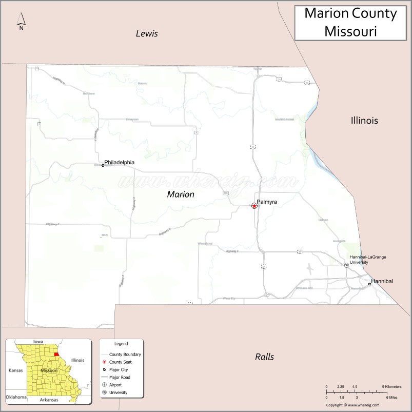
Map of Marion County, Missouri
About McDonald County Map, Missouri: The map showing the county boundary, county seat, major cities, highways, water bodies and neighbouring counties.
Related Missouri Maps & Info
Marion County, Missouri
Marion County is a county located in the U.S. state of Missouri. It's county seat is Palmyra. As per 2020 census, the population of Marion County is 28518 people and population density is square miles. According to the United States Census Bureau, the county has a total area of 438 sq mi (1,134 km2). Marion County was established on 1826.
Marion County Facts
| Continent | North America |
| Country | United States |
| State | Missouri |
| County Seat | Palmyra |
| Largest City/Town | Hannibal |
| Established | 1826 |
| Total Area | 444 sq mi (1,150 sq km) |
| Land Area | 437 sq mi (1,132 sq km) |
| Water Area | 7 sq mi (18 sq km) |
| Population | 28,525 (Census 2020) |
| Population Density | 65.3 people per sq mi |
| Time Zone | Central Time Zone (CST/CDT) |
| Major Highways | U.S. Route 24, U.S. Route 36, U.S. Route 61, Interstate 72 nearby region |
| Major Rivers | Mississippi River |
| Neighboring Counties | Lewis County, Ralls County, Shelby County, Adams County (Illinois), Pike County (Illinois) |
| Famous For | Mark Twain heritage, Hannibal riverfront, historic sites, and Mississippi River tourism |
| Top Attractions | Mark Twain Boyhood Home and Museum, Hannibal riverfront, cave tours, and historic downtown districts |
| Official Website | Official Website |
About Marion County
Marion County is located in northeastern Missouri along the Mississippi River and was established in 1826. The county seat is Palmyra, while Hannibal is the largest city. The county is internationally known as the boyhood home of Mark Twain and for its scenic riverfront tourism, historic architecture, and cultural attractions.
Cities and Towns in Marion County, Missouri
| City/Town | Population (Census 2020) | Latitude & Longitude |
|---|---|---|
| Hannibal | 17,108 | 39.7084°N, 91.3585°W |
| Palmyra (county seat) | 3,595 | 39.7945°N, 91.5232°W |
| Monroe City nearby region | 2,531 | 39.6534°N, 91.7349°W |
| Philadelphia | 196 | 39.8695°N, 91.7241°W |
| Taylor | 586 | 39.9325°N, 91.4091°W |
| Maywood nearby area | 267 | 39.9397°N, 91.6027°W |
What are the Golf Courses in Marion County
| Golf Course | Location | Latitude & Longitude |
|---|---|---|
| Norwoods Golf Club | Hannibal | 39.7194°N, 91.3691°W |
| Hannibal Country Club | Hannibal | 39.6978°N, 91.3455°W |
| Palmyra Golf Course | Palmyra | 39.8041°N, 91.5340°W |
Major Roads and Highways in Marion County
Major highways connect Marion County with the Mississippi River region, Illinois, and northern Missouri communities.
- U.S. Route 24 - major east-west transportation route through northeastern Missouri
- U.S. Route 36 - important expressway linking Missouri and Illinois
- U.S. Route 61 - north-south corridor along the Mississippi River
- Interstate 72 nearby region - regional interstate access to Illinois and the Midwest
What are Neighboring Counties of Marion County
- Lewis County (northwest)
- Shelby County (west)
- Ralls County (south)
- Adams County, Illinois (east)
- Pike County, Illinois (southeast)
What Are the Top Attractions in Marion County
The county offers literary history, Mississippi River attractions, caves, museums, and outdoor recreation.
- Mark Twain Boyhood Home and Museum - exhibits dedicated to Samuel Clemens and literary history
- Historic Downtown Hannibal - shops, restaurants, murals, and riverfront attractions
- Mark Twain Cave Complex - guided cave tours and geological formations
- Mississippi Riverfront Parks - scenic views, riverboat cruises, and recreation
- Rockcliffe Mansion - preserved Victorian mansion and historic tours
- Lovers Leap Overlook - panoramic Mississippi River photography location
- Hannibal History Museum - exhibits on river trade and regional heritage
- Palmyra Courthouse Square - historic architecture and community events
- Community Festivals and Tom Sawyer Celebrations - cultural events and family entertainment
- Fishing, Boating, and Outdoor Recreation Areas - Mississippi River activities and nature exploration
What Is the Distance from Marion County to Nearby Cities
The following distances are measured by road (driving).
- Hannibal to Quincy (Adams County), Illinois - 18 mi (29 km)
- Hannibal to Columbia (Boone County), Missouri - 116 mi (187 km)
- Hannibal to Kirksville (Adair County), Missouri - 86 mi (138 km)
- Hannibal to St. Louis (St. Louis City), Missouri - 115 mi (185 km)
- Hannibal to Palmyra (Marion County), Missouri - 10 mi (16 km)
- Hannibal to Taylor (Marion County), Missouri - 15 mi (24 km)
- Hannibal to Springfield (Greene County), Illinois - 100 mi (161 km)
- Hannibal to Kansas City (Jackson County), Missouri - 238 mi (383 km)
- Hannibal to Chicago (Cook County), Illinois - 284 mi (457 km)
- Hannibal to Des Moines (Polk County), Iowa - 220 mi (354 km)
- Hannibal to Minneapolis (Hennepin County), Minnesota - 431 mi (694 km)
- Hannibal to Nashville (Davidson County), Tennessee - 399 mi (642 km)
- Hannibal to Denver (Denver County), Colorado - 738 mi (1,188 km)
FAQs about Marion County
Marion County is located in northeastern Missouri along the Mississippi River.
Marion County had a population of 28,525 according to the 2020 United States Census.
Marion County is known for Mark Twain heritage, Hannibal tourism, Mississippi River attractions, and historic sites.
The county is served by U.S. Route 24, U.S. Route 36, U.S. Route 61, and nearby Interstate 72 access.
Yes, Marion County includes golf facilities such as Norwoods Golf Club, Hannibal Country Club, and Palmyra Golf Course.
References
- QuickFacts - U.S. Census Bureau
- United States Census Bureau
- United States Geological Survey (USGS)
- National Geodetic Survey
- Official Website
- Adair County Map
- Andrew County Map
- Atchison County Map
- Audrain County Map
- Barry County Map
- Barton County Map
- Bates County Map
- Benton County Map
- Bollinger County Map
- Boone County Map
- Buchanan County Map
- Butler County Map
- Caldwell County Map
- Callaway County Map
- Camden County Map
- Cape Girardeau County Map
- Carroll County Map
- Carter County Map
- Cass County Map
- Cedar County Map
- Chariton County Map
- Christian County Map
- Clark County Map
- Clay County Map
- Clinton County Map
- Cole County Map
- Cooper County Map
- Crawford County Map
- Dade County Map
- Dallas County Map
- Daviess County Map
- DeKalb County Map
- Dent County Map
- Douglas County Map
- Dunklin County Map
- Franklin County Map
- Gasconade County Map
- Gentry County Map
- Greene County Map
- Grundy County Map
- Harrison County Map
- Henry County Map
- Hickory County Map
- Holt County Map
- Howard County Map
- Howell County Map
- Iron County Map
- Jackson County Map
- Jasper County Map
- Jefferson County Map
- Johnson County Map
- Knox County Map
- Laclede County Map
- Lafayette County Map
- Lawrence County Map
- Lewis County Map
- Lincoln County Map
- Linn County Map
- Livingston County Map
- McDonald County Map
- Macon County Map
- Madison County Map
- Maries County Map
- Marion County Map
- Mercer County Map
- Miller County Map
- Mississippi County Map
- Moniteau County Map
- Monroe County Map
- Montgomery County Map
- Morgan County Map
- New Madrid County Map
- Newton County Map
- Nodaway County Map
- Oregon County Map
- Osage County Map
- Ozark County Map
- Pemiscot County Map
- Perry County Map
- Pettis County Map
- Phelps County Map
- Pike County Map
- Platte County Map
- Polk County Map
- Pulaski County Map
- Putnam County Map
- Ralls County Map
- Randolph County Map
- Ray County Map
- Reynolds County Map
- Ripley County Map
- St Charles County Map
- St Clair County Map
- Ste Genevieve County Map
- St Francois County Map
- St Louis County Map
- Saline County Map
- Schuyler County Map
- Scotland County Map
- Scott County Map
- Shannon County Map
- Shelby County Map
- Stoddard County Map
- Stone County Map
- Sullivan County Map
- Taney County Map
- Texas County Map
- Vernon County Map
- Warren County Map
- Washington County Map
- Wayne County Map
- Webster County Map
- Worth County Map
- Wright County Map
- St Louis County Map
- Alabama Counties
- Alaska boroughs
- Arizona Counties
- Arkansas Counties
- California County Map
- Colorado Counties
- Connecticut Counties
- Delaware Counties
- Florida County Map
- Georgia County Map
- Hawaii Counties
- Idaho Counties
- Illinois Counties
- Indiana Counties
- Iowa Counties
- Kansas Counties
- Kentucky Counties
- Louisiana Counties
- Maine Counties
- Maryland Counties
- Massachusetts Counties
- Michigan County Map
- Minnesota Counties
- Mississippi Counties
- Missouri Counties
- Montana Counties
- Nebraska Counties
- Nevada Counties
- New York Counties
- New Hampshire Counties
- New Jersey Counties
- New Mexico Counties
- North Carolina Counties
- North Dakota Counties
- Ohio County Map
- Oklahoma Counties
- Oregon Counties
- Pennsylvania Counties
- Rhode Island Counties
- South Carolina Counties
- South Dakota Counties
- Map of Tennessee
- Texas County Map
- Utah Counties
- Vermont Counties
- Virginia Counties
- Washington Counties
- West Virginia Counties
- Wisconsin Counties
- Wyoming Counties