Map of Lewis County - Lewis County is a county located in the U.S. state of Missouri. Lewis County Map showing cities, highways, important places and water bodies. Get Where is Lewis County located in the map, major cities in Lewis county, population, areas, and places of interest.
Map of Lewis County, Missouri
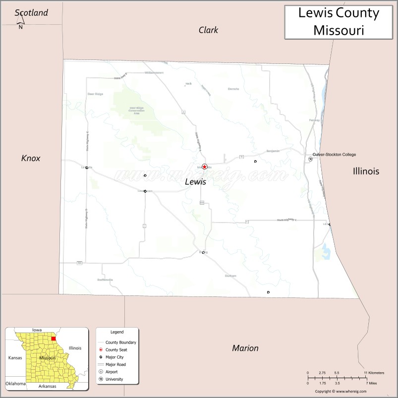
About Lewis County Map, Missouri: The map showing the county boundary, county seat, major cities, highways, water bodies and neighbouring counties.
Related Missouri Maps & Info
Lewis County, Missouri
Lewis County is a county located in the U.S. state of Missouri. It's county seat is Monticello. As per 2020 census, the population of Lewis County is 10000 people and population density is square miles. According to the United States Census Bureau, the county has a total area of 505 sq mi (1,308 km2). Lewis County was established on 1833.
Lewis County Facts
| Continent | North America |
| Country | United States |
| State | Missouri |
| County Seat | Monticello |
| Largest City/Town | Canton |
| Established | 1833 |
| Total Area | 511 sq mi (1,323 sq km) |
| Land Area | 505 sq mi (1,308 sq km) |
| Water Area | 6 sq mi (15 sq km) |
| Population | 9,920 (Census 2020) |
| Population Density | 19.6 people per sq mi |
| Time Zone | Central Time Zone (CST/CDT) |
| Major Highways | U.S. Route 61, Missouri Route 6, Missouri Route 16 |
| Major Rivers | Mississippi River, North Fabius River |
| Neighboring Counties | Clark County, Knox County, Shelby County, Marion County, Adams County (Illinois) |
| Famous For | Mississippi River communities, agriculture, hunting, and historic small towns |
| Top Attractions | Wakonda State Park nearby region, Canton riverfront, historic Monticello, and wildlife conservation areas |
| Official Website | Official Website |
About Lewis County
Lewis County is located in northeastern Missouri along the Mississippi River and was established in 1833. The county seat is Monticello, while Canton is the largest city. The county is known for agriculture, riverfront communities, scenic countryside, hunting, and outdoor recreation along the Mississippi River corridor.
Cities and Towns in Lewis County, Missouri
| City/Town | Population (Census 2020) | Latitude & Longitude |
|---|---|---|
| Canton | 2,377 | 40.1306°N, 91.5207°W |
| La Belle | 660 | 39.9870°N, 91.9132°W |
| Lewistown | 521 | 40.0856°N, 91.8171°W |
| Ewing | 373 | 40.0078°N, 91.7141°W |
| Monticello (county seat) | 98 | 40.1045°N, 91.7171°W |
| Durham nearby area | 118 | 39.9578°N, 91.8484°W |
What are the Golf Courses in Lewis County
| Golf Course | Location | Latitude & Longitude |
|---|---|---|
| Canton Municipal Golf Course | Canton | 40.1391°N, 91.5302°W |
| La Belle Golf Recreation Area | La Belle | 39.9945°N, 91.9208°W |
Major Roads and Highways in Lewis County
Major highways connect Lewis County with northeastern Missouri communities and the Mississippi River region.
- U.S. Route 61 - important north-south transportation corridor along the Mississippi River
- Missouri Route 6 - east-west route connecting rural communities and farmland
- Missouri Route 16 - regional highway serving local towns and agricultural areas
What are Neighboring Counties of Lewis County
- Clark County (north)
- Knox County (west)
- Shelby County (southwest)
- Marion County (south)
- Adams County, Illinois (east)
What Are the Top Attractions in Lewis County
The county offers riverfront scenery, outdoor recreation, wildlife areas, and historic small-town attractions.
- Wakonda State Park nearby region - fishing lakes, camping, hiking, and birdwatching
- Canton Riverfront Area - Mississippi River views, parks, and recreation opportunities
- Historic Monticello - courthouse square and preserved pioneer-era landmarks
- Wildlife Conservation Areas - hunting, wildlife observation, and outdoor recreation
- North Fabius River Recreation - fishing, kayaking, and nature viewing
- Historic Rural Churches and Barns - agricultural heritage landmarks and scenic countryside
- Community Festivals and County Fairs - seasonal celebrations and farming traditions
- Scenic Mississippi River Drives - photography locations and river valley landscapes
- Local Museums and Heritage Displays - exhibits on pioneer settlement and river trade history
- Prairie and Farmland Recreation Areas - outdoor activities and rural tourism experiences
What Is the Distance from Lewis County to Nearby Cities
The following distances are measured by road (driving).
- Canton to Quincy (Adams County), Illinois - 16 mi (26 km)
- Canton to Hannibal (Marion County), Missouri - 32 mi (51 km)
- Canton to Kirksville (Adair County), Missouri - 71 mi (114 km)
- Canton to Columbia (Boone County), Missouri - 144 mi (232 km)
- Canton to La Belle (Lewis County), Missouri - 25 mi (40 km)
- Canton to Lewistown (Lewis County), Missouri - 18 mi (29 km)
- Canton to St. Louis (St. Louis City), Missouri - 175 mi (282 km)
- Canton to Kansas City (Jackson County), Missouri - 245 mi (394 km)
- Canton to Des Moines (Polk County), Iowa - 199 mi (320 km)
- Canton to Chicago (Cook County), Illinois - 291 mi (468 km)
- Canton to Minneapolis (Hennepin County), Minnesota - 422 mi (679 km)
- Canton to Nashville (Davidson County), Tennessee - 451 mi (726 km)
- Canton to Denver (Denver County), Colorado - 740 mi (1,191 km)
FAQs about Lewis County
Lewis County is located in northeastern Missouri along the Mississippi River.
Lewis County had a population of 9,920 according to the 2020 United States Census.
Lewis County is known for Mississippi River communities, agriculture, hunting, and outdoor recreation.
The county is served by U.S. Route 61, Missouri Route 6, and Missouri Route 16.
Yes, Lewis County includes golf facilities such as Canton Municipal Golf Course and La Belle Golf Recreation Area.
References
- QuickFacts - U.S. Census Bureau
- United States Census Bureau
- United States Geological Survey (USGS)
- National Geodetic Survey
- Official Website
- Adair County Map
- Andrew County Map
- Atchison County Map
- Audrain County Map
- Barry County Map
- Barton County Map
- Bates County Map
- Benton County Map
- Bollinger County Map
- Boone County Map
- Buchanan County Map
- Butler County Map
- Caldwell County Map
- Callaway County Map
- Camden County Map
- Cape Girardeau County Map
- Carroll County Map
- Carter County Map
- Cass County Map
- Cedar County Map
- Chariton County Map
- Christian County Map
- Clark County Map
- Clay County Map
- Clinton County Map
- Cole County Map
- Cooper County Map
- Crawford County Map
- Dade County Map
- Dallas County Map
- Daviess County Map
- DeKalb County Map
- Dent County Map
- Douglas County Map
- Dunklin County Map
- Franklin County Map
- Gasconade County Map
- Gentry County Map
- Greene County Map
- Grundy County Map
- Harrison County Map
- Henry County Map
- Hickory County Map
- Holt County Map
- Howard County Map
- Howell County Map
- Iron County Map
- Jackson County Map
- Jasper County Map
- Jefferson County Map
- Johnson County Map
- Knox County Map
- Laclede County Map
- Lafayette County Map
- Lawrence County Map
- Lewis County Map
- Lincoln County Map
- Linn County Map
- Livingston County Map
- McDonald County Map
- Macon County Map
- Madison County Map
- Maries County Map
- Marion County Map
- Mercer County Map
- Miller County Map
- Mississippi County Map
- Moniteau County Map
- Monroe County Map
- Montgomery County Map
- Morgan County Map
- New Madrid County Map
- Newton County Map
- Nodaway County Map
- Oregon County Map
- Osage County Map
- Ozark County Map
- Pemiscot County Map
- Perry County Map
- Pettis County Map
- Phelps County Map
- Pike County Map
- Platte County Map
- Polk County Map
- Pulaski County Map
- Putnam County Map
- Ralls County Map
- Randolph County Map
- Ray County Map
- Reynolds County Map
- Ripley County Map
- St Charles County Map
- St Clair County Map
- Ste Genevieve County Map
- St Francois County Map
- St Louis County Map
- Saline County Map
- Schuyler County Map
- Scotland County Map
- Scott County Map
- Shannon County Map
- Shelby County Map
- Stoddard County Map
- Stone County Map
- Sullivan County Map
- Taney County Map
- Texas County Map
- Vernon County Map
- Warren County Map
- Washington County Map
- Wayne County Map
- Webster County Map
- Worth County Map
- Wright County Map
- St Louis County Map
- Alabama Counties
- Alaska boroughs
- Arizona Counties
- Arkansas Counties
- California County Map
- Colorado Counties
- Connecticut Counties
- Delaware Counties
- Florida County Map
- Georgia County Map
- Hawaii Counties
- Idaho Counties
- Illinois Counties
- Indiana Counties
- Iowa Counties
- Kansas Counties
- Kentucky Counties
- Louisiana Counties
- Maine Counties
- Maryland Counties
- Massachusetts Counties
- Michigan County Map
- Minnesota Counties
- Mississippi Counties
- Missouri Counties
- Montana Counties
- Nebraska Counties
- Nevada Counties
- New York Counties
- New Hampshire Counties
- New Jersey Counties
- New Mexico Counties
- North Carolina Counties
- North Dakota Counties
- Ohio County Map
- Oklahoma Counties
- Oregon Counties
- Pennsylvania Counties
- Rhode Island Counties
- South Carolina Counties
- South Dakota Counties
- Map of Tennessee
- Texas County Map
- Utah Counties
- Vermont Counties
- Virginia Counties
- Washington Counties
- West Virginia Counties
- Wisconsin Counties
- Wyoming Counties