Map of Ozark County - Ozark County is a county located in the U.S. state of Missouri. Ozark County Map showing cities, highways, important places and water bodies. Get Where is Ozark County located in the map, major cities in Ozark county, population, areas, and places of interest.
Map of Ozark County, Missouri
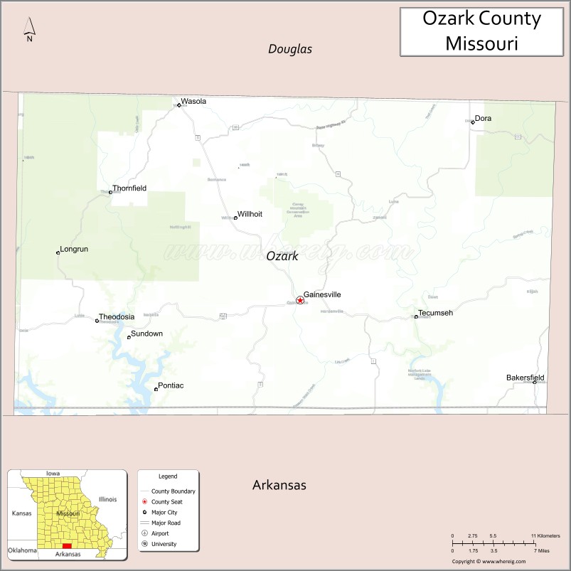
About Ozark County Map, Missouri: The map showing the county boundary, county seat, major cities, highways, water bodies and neighbouring counties.
Related Missouri Maps & Info
Ozark County, Missouri
Ozark County is a county located in the U.S. state of Missouri. It's county seat is Gainesville. As per 2020 census, the population of Ozark County is 8782 people and population density is square miles. According to the United States Census Bureau, the county has a total area of 747 sq mi (1,935 km2). Ozark County was established on 1841.
Ozark County Facts
| Continent | North America |
| Country | United States |
| State | Missouri |
| County Seat | Gainesville |
| Largest City/Town | Gainesville |
| Established | 1841 |
| Total Area | 755 sq mi (1,955 sq km) |
| Land Area | 745 sq mi (1,930 sq km) |
| Water Area | 10 sq mi (25 sq km) |
| Population | 9,470 (Census 2020) |
| Population Density | 12.7 people per sq mi |
| Time Zone | Central Time Zone (CST/CDT) |
| Major Highways | Missouri Route 5, Missouri Route 181, Missouri Route 160 nearby region |
| Major Rivers | North Fork River, Bryant Creek, Bull Shoals Lake nearby region |
| Neighboring Counties | Douglas County, Howell County, Taney County, Marion County (Arkansas), Baxter County (Arkansas) |
| Famous For | Ozark Mountains scenery, rivers, fishing, floating recreation, and rural wilderness |
| Top Attractions | North Fork River, Bull Shoals Lake nearby region, Hodgson Mill, and Mark Twain National Forest |
| Official Website | Official Website |
About Ozark County
Ozark County is located in southern Missouri within the Ozark Mountains near the Arkansas border and was established in 1841. The county seat and largest city is Gainesville. The county is known for scenic rivers, forested hills, floating recreation, fishing, and peaceful wilderness landscapes.
Cities and Towns in Ozark County, Missouri
| City/Town | Population (Census 2020) | Latitude & Longitude |
|---|---|---|
| Gainesville (county seat) | 745 | 36.6031°N, 92.4285°W |
| Theodosia | 243 | 36.5809°N, 92.6735°W |
| Wasola nearby area | 169 | 36.5301°N, 92.5790°W |
| Udall nearby region | 247 | 36.4578°N, 92.2171°W |
| Hardenville nearby area | 78 | 36.6842°N, 92.2768°W |
| Pontiac nearby region | 94 | 36.5143°N, 92.5962°W |
What are the Golf Courses in Ozark County
| Golf Course | Location | Latitude & Longitude |
|---|---|---|
| Gainesville Recreation Golf Area | Gainesville | 36.6112°N, 92.4387°W |
| Theodosia Lakeside Golf Course | Theodosia | 36.5891°N, 92.6839°W |
| Ozark Hills Community Golf Area | Wasola nearby region | 36.5388°N, 92.5884°W |
Major Roads and Highways in Ozark County
Major highways connect Ozark County with southern Missouri recreation regions and northern Arkansas communities.
- Missouri Route 5 - major north-south highway through the Ozark Mountains
- Missouri Route 181 - scenic route serving rivers, forests, and rural communities
- Missouri Route 160 nearby region - important east-west transportation corridor across southern Missouri
What are Neighboring Counties of Ozark County
- Douglas County (north)
- Howell County (east)
- Taney County (west)
- Marion County, Arkansas (southwest)
- Baxter County, Arkansas (south)
What Are the Top Attractions in Ozark County
The county offers scenic rivers, outdoor recreation, historic mills, and forested Ozark landscapes.
- North Fork River - floating, kayaking, fishing, and swimming recreation
- Bull Shoals Lake nearby region - boating, camping, and lakeside fishing
- Hodgson Mill - historic grist mill and scenic photography destination
- Mark Twain National Forest - hiking, wildlife observation, and camping
- Gainesville Historic District - courthouse square and local heritage attractions
- Ozark Scenic Drives - mountain landscapes, forests, and river valleys
- Fishing Resorts and Campgrounds - family recreation and outdoor tourism
- Bryant Creek Recreation Areas - canoeing and nature exploration
- Wildlife Conservation Areas - hunting, birdwatching, and hiking opportunities
- Community Festivals and Rural Heritage Events - seasonal entertainment and local traditions
What Is the Distance from Ozark County to Nearby Cities
The following distances are measured by road (driving).
- Gainesville to West Plains (Howell County), Missouri - 37 mi (60 km)
- Gainesville to Branson (Taney County), Missouri - 79 mi (127 km)
- Gainesville to Mountain Home (Baxter County), Arkansas - 29 mi (47 km)
- Gainesville to Springfield (Greene County), Missouri - 122 mi (196 km)
- Gainesville to Theodosia (Ozark County), Missouri - 18 mi (29 km)
- Gainesville to Udall (Ozark County), Missouri - 24 mi (39 km)
- Gainesville to Little Rock (Pulaski County), Arkansas - 171 mi (275 km)
- Gainesville to St. Louis (St. Louis City), Missouri - 259 mi (417 km)
- Gainesville to Kansas City (Jackson County), Missouri - 278 mi (447 km)
- Gainesville to Memphis (Shelby County), Tennessee - 274 mi (441 km)
- Gainesville to Dallas (Dallas County), Texas - 439 mi (707 km)
- Gainesville to Chicago (Cook County), Illinois - 504 mi (811 km)
- Gainesville to Denver (Denver County), Colorado - 799 mi (1,286 km)
FAQs about Ozark County
Ozark County is located in southern Missouri within the Ozark Mountains near the Arkansas border.
Ozark County had a population of 9,470 according to the 2020 United States Census.
Ozark County is known for scenic rivers, forested mountains, floating recreation, and Ozark wilderness landscapes.
The county is served by Missouri Route 5, Missouri Route 181, and nearby Missouri Route 160.
Yes, Ozark County includes golf and recreation facilities near Gainesville and Theodosia.
References
- QuickFacts - U.S. Census Bureau
- United States Census Bureau
- United States Geological Survey (USGS)
- National Geodetic Survey
- Official Website
- Adair County Map
- Andrew County Map
- Atchison County Map
- Audrain County Map
- Barry County Map
- Barton County Map
- Bates County Map
- Benton County Map
- Bollinger County Map
- Boone County Map
- Buchanan County Map
- Butler County Map
- Caldwell County Map
- Callaway County Map
- Camden County Map
- Cape Girardeau County Map
- Carroll County Map
- Carter County Map
- Cass County Map
- Cedar County Map
- Chariton County Map
- Christian County Map
- Clark County Map
- Clay County Map
- Clinton County Map
- Cole County Map
- Cooper County Map
- Crawford County Map
- Dade County Map
- Dallas County Map
- Daviess County Map
- DeKalb County Map
- Dent County Map
- Douglas County Map
- Dunklin County Map
- Franklin County Map
- Gasconade County Map
- Gentry County Map
- Greene County Map
- Grundy County Map
- Harrison County Map
- Henry County Map
- Hickory County Map
- Holt County Map
- Howard County Map
- Howell County Map
- Iron County Map
- Jackson County Map
- Jasper County Map
- Jefferson County Map
- Johnson County Map
- Knox County Map
- Laclede County Map
- Lafayette County Map
- Lawrence County Map
- Lewis County Map
- Lincoln County Map
- Linn County Map
- Livingston County Map
- McDonald County Map
- Macon County Map
- Madison County Map
- Maries County Map
- Marion County Map
- Mercer County Map
- Miller County Map
- Mississippi County Map
- Moniteau County Map
- Monroe County Map
- Montgomery County Map
- Morgan County Map
- New Madrid County Map
- Newton County Map
- Nodaway County Map
- Oregon County Map
- Osage County Map
- Ozark County Map
- Pemiscot County Map
- Perry County Map
- Pettis County Map
- Phelps County Map
- Pike County Map
- Platte County Map
- Polk County Map
- Pulaski County Map
- Putnam County Map
- Ralls County Map
- Randolph County Map
- Ray County Map
- Reynolds County Map
- Ripley County Map
- St Charles County Map
- St Clair County Map
- Ste Genevieve County Map
- St Francois County Map
- St Louis County Map
- Saline County Map
- Schuyler County Map
- Scotland County Map
- Scott County Map
- Shannon County Map
- Shelby County Map
- Stoddard County Map
- Stone County Map
- Sullivan County Map
- Taney County Map
- Texas County Map
- Vernon County Map
- Warren County Map
- Washington County Map
- Wayne County Map
- Webster County Map
- Worth County Map
- Wright County Map
- St Louis County Map
- Alabama Counties
- Alaska boroughs
- Arizona Counties
- Arkansas Counties
- California County Map
- Colorado Counties
- Connecticut Counties
- Delaware Counties
- Florida County Map
- Georgia County Map
- Hawaii Counties
- Idaho Counties
- Illinois Counties
- Indiana Counties
- Iowa Counties
- Kansas Counties
- Kentucky Counties
- Louisiana Counties
- Maine Counties
- Maryland Counties
- Massachusetts Counties
- Michigan County Map
- Minnesota Counties
- Mississippi Counties
- Missouri Counties
- Montana Counties
- Nebraska Counties
- Nevada Counties
- New York Counties
- New Hampshire Counties
- New Jersey Counties
- New Mexico Counties
- North Carolina Counties
- North Dakota Counties
- Ohio County Map
- Oklahoma Counties
- Oregon Counties
- Pennsylvania Counties
- Rhode Island Counties
- South Carolina Counties
- South Dakota Counties
- Map of Tennessee
- Texas County Map
- Utah Counties
- Vermont Counties
- Virginia Counties
- Washington Counties
- West Virginia Counties
- Wisconsin Counties
- Wyoming Counties