Map of Henry County - Henry County is a county located in the U.S. state of Missouri. Henry County Map showing cities, highways, important places and water bodies. Get Where is Henry County located in the map, major cities in Henry county, population, areas, and places of interest.
Map of Henry County, Missouri
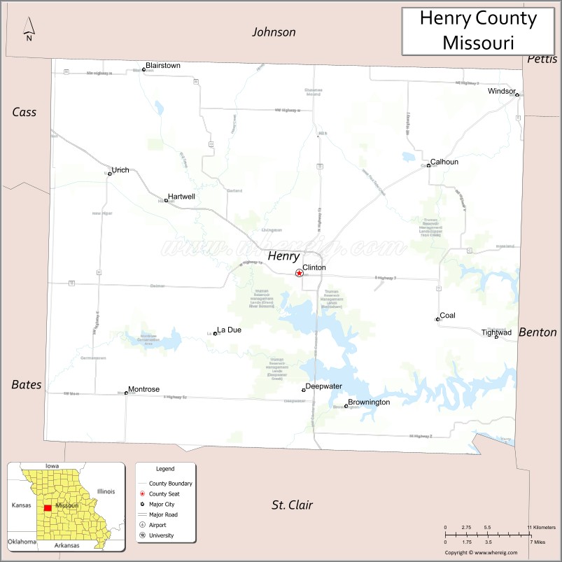
About Henry County Map, Missouri: The map showing the county boundary, county seat, major cities, highways, water bodies and neighbouring counties.
Related Missouri Maps & Info
Henry County, Missouri
Henry County is a county located in the U.S. state of Missouri. It's county seat is Clinton. As per 2020 census, the population of Henry County is 22206 people and population density is square miles. According to the United States Census Bureau, the county has a total area of 702 sq mi (1,818 km2). Henry County was established on 1834.
Henry County Facts
| Continent | North America |
| Country | United States |
| State | Missouri |
| County Seat | Clinton |
| Largest City/Town | Clinton |
| Established | 1834 |
| Total Area | 732 sq mi (1,896 sq km) |
| Land Area | 697 sq mi (1,805 sq km) |
| Water Area | 35 sq mi (91 sq km) |
| Population | 21,473 (Census 2020) |
| Population Density | 30.8 people per sq mi |
| Time Zone | Central Time Zone (CST/CDT) |
| Major Highways | U.S. Route 7, Missouri Route 13, Missouri Route 18, Missouri Route 52 |
| Major Rivers | South Grand River, Osage River nearby region |
| Neighboring Counties | Benton County, Pettis County, Johnson County, St. Clair County, Bates County |
| Famous For | Truman Lake recreation, fishing, agriculture, and outdoor tourism |
| Top Attractions | Truman Lake, Clinton historic square, Katy Trail nearby region, and conservation areas |
| Official Website | Official Website |
About Henry County
Henry County is located in west-central Missouri and was established in 1834. The county seat and largest city is Clinton. The county is known for outdoor recreation, Truman Lake tourism, fishing, camping, agriculture, and scenic landscapes surrounding central Missouri lakes and river valleys.
Cities and Towns in Henry County, Missouri
| City/Town | Population (Census 2020) | Latitude & Longitude |
|---|---|---|
| Clinton (county seat) | 9,174 | 38.3681°N, 93.7783°W |
| Windsor | 2,146 | 38.5325°N, 93.5222°W |
| Calhoun | 469 | 38.4678°N, 93.6257°W |
| Deepwater | 425 | 38.2578°N, 93.7069°W |
| Montrose | 384 | 38.2570°N, 93.9671°W |
| Blairstown | 92 | 38.5320°N, 93.9684°W |
What are the Golf Courses in Henry County
| Golf Course | Location | Latitude & Longitude |
|---|---|---|
| Clinton Country Club | Clinton | 38.3757°N, 93.7862°W |
| Meadow Lake Golf Course | Windsor | 38.5391°N, 93.5308°W |
Major Roads and Highways in Henry County
Major highways connect the county with Kansas City, Truman Lake recreation areas, and central Missouri communities.
- U.S. Route 7 - major north-south transportation corridor through western Missouri
- Missouri Route 13 - regional highway linking recreational and agricultural communities
- Missouri Route 18 - east-west route connecting towns across west-central Missouri
- Missouri Route 52 - scenic transportation route serving rural communities
What are Neighboring Counties of Henry County
- Johnson County (north)
- Pettis County (east)
- Benton County (southeast)
- St. Clair County (south)
- Bates County (west)
What Are the Top Attractions in Henry County
The county offers lakeside recreation, historic attractions, and scenic countryside experiences.
- Truman Lake - boating, fishing, camping, and water sports recreation
- Clinton Historic Square - local shops, dining, and historic architecture
- Katy Trail nearby region - biking and hiking opportunities across scenic Missouri landscapes
- Corps of Engineers Recreation Areas - campgrounds, marinas, and picnic sites
- Henry County Museum - exhibits on pioneer settlement and regional history
- Deepwater Lake Recreation - fishing, kayaking, and outdoor activities
- Windsor Community Parks - family recreation and sports facilities
- Conservation Areas and Wildlife Habitats - birdwatching, hiking, and hunting
- Scenic Countryside Drives - rolling farmland and lake views
- County Fairs and Community Festivals - agricultural traditions and seasonal celebrations
What Is the Distance from Henry County to Nearby Cities
The following distances are measured by road (driving).
- Clinton to Kansas City (Jackson County), Missouri - 76 mi (122 km)
- Clinton to Springfield (Greene County), Missouri - 112 mi (180 km)
- Clinton to Jefferson City (Cole County), Missouri - 108 mi (174 km)
- Clinton to Sedalia (Pettis County), Missouri - 39 mi (63 km)
- Clinton to Windsor (Henry County), Missouri - 25 mi (40 km)
- Clinton to Deepwater (Henry County), Missouri - 16 mi (26 km)
- Clinton to Branson (Taney County), Missouri - 173 mi (278 km)
- Clinton to St. Louis (St. Louis City), Missouri - 243 mi (391 km)
- Clinton to Wichita (Sedgwick County), Kansas - 241 mi (388 km)
- Clinton to Tulsa (Tulsa County), Oklahoma - 225 mi (362 km)
- Clinton to Chicago (Cook County), Illinois - 516 mi (830 km)
- Clinton to Denver (Denver County), Colorado - 609 mi (980 km)
- Clinton to Dallas (Dallas County), Texas - 508 mi (818 km)
FAQs about Henry County
Henry County is located in west-central Missouri.
Henry County had a population of 21,473 according to the 2020 United States Census.
Henry County is known for Truman Lake recreation, fishing, agriculture, and outdoor tourism.
The county is served by U.S. Route 7, Missouri Route 13, Missouri Route 18, and Missouri Route 52.
Yes, Henry County includes golf facilities such as Clinton Country Club and Meadow Lake Golf Course.
References
- QuickFacts - U.S. Census Bureau
- United States Census Bureau
- United States Geological Survey (USGS)
- National Geodetic Survey
- Official Website
- Adair County Map
- Andrew County Map
- Atchison County Map
- Audrain County Map
- Barry County Map
- Barton County Map
- Bates County Map
- Benton County Map
- Bollinger County Map
- Boone County Map
- Buchanan County Map
- Butler County Map
- Caldwell County Map
- Callaway County Map
- Camden County Map
- Cape Girardeau County Map
- Carroll County Map
- Carter County Map
- Cass County Map
- Cedar County Map
- Chariton County Map
- Christian County Map
- Clark County Map
- Clay County Map
- Clinton County Map
- Cole County Map
- Cooper County Map
- Crawford County Map
- Dade County Map
- Dallas County Map
- Daviess County Map
- DeKalb County Map
- Dent County Map
- Douglas County Map
- Dunklin County Map
- Franklin County Map
- Gasconade County Map
- Gentry County Map
- Greene County Map
- Grundy County Map
- Harrison County Map
- Henry County Map
- Hickory County Map
- Holt County Map
- Howard County Map
- Howell County Map
- Iron County Map
- Jackson County Map
- Jasper County Map
- Jefferson County Map
- Johnson County Map
- Knox County Map
- Laclede County Map
- Lafayette County Map
- Lawrence County Map
- Lewis County Map
- Lincoln County Map
- Linn County Map
- Livingston County Map
- McDonald County Map
- Macon County Map
- Madison County Map
- Maries County Map
- Marion County Map
- Mercer County Map
- Miller County Map
- Mississippi County Map
- Moniteau County Map
- Monroe County Map
- Montgomery County Map
- Morgan County Map
- New Madrid County Map
- Newton County Map
- Nodaway County Map
- Oregon County Map
- Osage County Map
- Ozark County Map
- Pemiscot County Map
- Perry County Map
- Pettis County Map
- Phelps County Map
- Pike County Map
- Platte County Map
- Polk County Map
- Pulaski County Map
- Putnam County Map
- Ralls County Map
- Randolph County Map
- Ray County Map
- Reynolds County Map
- Ripley County Map
- St Charles County Map
- St Clair County Map
- Ste Genevieve County Map
- St Francois County Map
- St Louis County Map
- Saline County Map
- Schuyler County Map
- Scotland County Map
- Scott County Map
- Shannon County Map
- Shelby County Map
- Stoddard County Map
- Stone County Map
- Sullivan County Map
- Taney County Map
- Texas County Map
- Vernon County Map
- Warren County Map
- Washington County Map
- Wayne County Map
- Webster County Map
- Worth County Map
- Wright County Map
- St Louis County Map
- Alabama Counties
- Alaska boroughs
- Arizona Counties
- Arkansas Counties
- California County Map
- Colorado Counties
- Connecticut Counties
- Delaware Counties
- Florida County Map
- Georgia County Map
- Hawaii Counties
- Idaho Counties
- Illinois Counties
- Indiana Counties
- Iowa Counties
- Kansas Counties
- Kentucky Counties
- Louisiana Counties
- Maine Counties
- Maryland Counties
- Massachusetts Counties
- Michigan County Map
- Minnesota Counties
- Mississippi Counties
- Missouri Counties
- Montana Counties
- Nebraska Counties
- Nevada Counties
- New York Counties
- New Hampshire Counties
- New Jersey Counties
- New Mexico Counties
- North Carolina Counties
- North Dakota Counties
- Ohio County Map
- Oklahoma Counties
- Oregon Counties
- Pennsylvania Counties
- Rhode Island Counties
- South Carolina Counties
- South Dakota Counties
- Map of Tennessee
- Texas County Map
- Utah Counties
- Vermont Counties
- Virginia Counties
- Washington Counties
- West Virginia Counties
- Wisconsin Counties
- Wyoming Counties