Map of Taney County - Taney County is a county located in the U.S. state of Missouri. Taney County Map showing cities, highways, important places and water bodies. Get Where is Taney County located in the map, major cities in Taney county, population, areas, and places of interest.
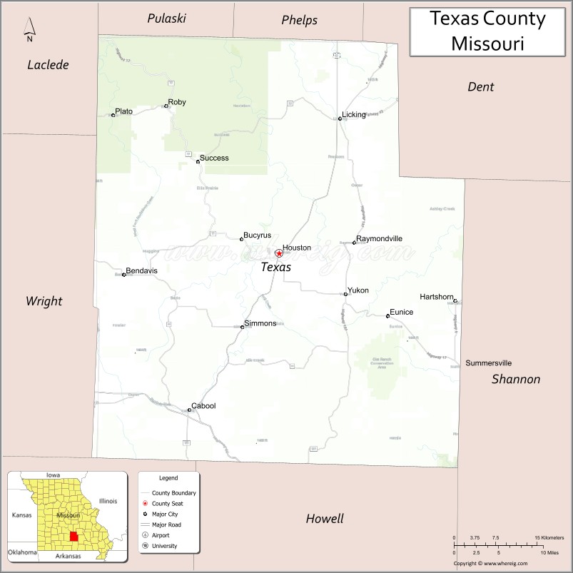
Map of Texas County, Missouri
About Taney County Map, Missouri: The map showing the county boundary, county seat, major cities, highways, water bodies and neighbouring counties.
Related Missouri Maps & Info
Texas County, Missouri
Texas County is a county located in the U.S. state of Missouri. It's county seat is Houston. As per 2020 census, the population of Texas County is 24987 people and population density is square miles. According to the United States Census Bureau, the county has a total area of 1,179 sq mi (3,054 km2). Texas County was established on 1843.
Texas County Facts
| Continent | North America |
| Country | United States |
| State | Missouri |
| County Seat | Houston |
| Largest City/Town | Houston |
| Established | 1843 |
| Total Area | 1,179 sq mi (3,054 sq km) |
| Land Area | 1,177 sq mi (3,049 sq km) |
| Water Area | 2 sq mi (5 sq km) |
| Population | 25,710 (Census 2020) |
| Population Density | 21.8 people per sq mi |
| Time Zone | Central Time Zone (CST/CDT) |
| Major Highways | U.S. Route 63, U.S. Route 60, Missouri Route 17, Missouri Route 38 |
| Major Rivers | Big Piney River, Current River nearby region |
| Neighboring Counties | Phelps County, Dent County, Wright County, Howell County, Shannon County, Pulaski County |
| Famous For | Mark Twain National Forest, rivers, outdoor recreation, and Ozark wilderness |
| Top Attractions | Big Piney River, Mark Twain National Forest, Montauk State Park nearby region, and Ozark Trail |
| Official Website | Official Website |
About Texas County
Texas County is located in south-central Missouri within the Ozark Highlands and was established in 1843. The county seat and largest city is Houston. Texas County is the largest county by land area in Missouri and is known for forests, rivers, hunting, camping, and outdoor recreation.
Cities and Towns in Texas County, Missouri
| City/Town | Population (Census 2020) | Latitude & Longitude |
|---|---|---|
| Houston (county seat) | 2,949 | 37.3267°N, 91.9557°W |
| Cabool | 2,146 | 37.1231°N, 92.1027°W |
| Licking | 1,263 | 37.4992°N, 91.8571°W |
| Summersville | 502 | 37.1798°N, 91.6549°W |
| Raymondville | 363 | 37.3359°N, 91.8404°W |
| Plato | 109 | 37.4814°N, 92.2154°W |
What are the Golf Courses in Texas County
| Golf Course | Location | Latitude & Longitude |
|---|---|---|
| Houston Municipal Golf Course | Houston | 37.3358°N, 91.9687°W |
| Cabool Golf Club | Cabool | 37.1309°N, 92.1161°W |
| Ozark Hills Recreation Golf Area | Licking nearby region | 37.5112°N, 91.8694°W |
Major Roads and Highways in Texas County
Major highways connect Texas County with the Ozark recreation region and central Missouri communities.
- U.S. Route 63 - major north-south transportation corridor through south-central Missouri
- U.S. Route 60 - important east-west highway serving the Ozarks region
- Missouri Route 17 - scenic route connecting forests and recreation areas
- Missouri Route 38 - regional connector serving rural communities
What are Neighboring Counties of Texas County
- Phelps County (north)
- Dent County (northeast)
- Shannon County (east)
- Howell County (south)
- Wright County (west)
- Pulaski County (northwest)
What Are the Top Attractions in Texas County
The county offers rivers, forests, hiking trails, and extensive outdoor recreation opportunities.
- Mark Twain National Forest - hiking, camping, hunting, and wildlife observation
- Big Piney River - canoeing, kayaking, fishing, and floating recreation
- Montauk State Park nearby region - trout fishing, hiking, and scenic landscapes
- Ozark Trail - backpacking, hiking, and wilderness exploration
- Current River nearby region - floating and outdoor recreation activities
- Camping and RV Parks - forest recreation and family outdoor experiences
- Hunting Conservation Areas - deer hunting, turkey hunting, and wildlife habitats
- Ozark Scenic Drives - rolling hills and countryside photography opportunities
- Community Festivals and Rural Heritage Events - local traditions and seasonal gatherings
- Nature Observation Areas - birdwatching and environmental exploration
What Is the Distance from Texas County to Nearby Cities
The following distances are measured by road (driving).
- Houston to Springfield (Greene County), Missouri - 95 mi (153 km)
- Houston to Rolla (Phelps County), Missouri - 72 mi (116 km)
- Houston to West Plains (Howell County), Missouri - 73 mi (117 km)
- Houston to Branson (Taney County), Missouri - 133 mi (214 km)
- Houston to Cabool (Texas County), Missouri - 17 mi (27 km)
- Houston to Licking (Texas County), Missouri - 20 mi (32 km)
- Houston to St. Louis (St. Louis City), Missouri - 176 mi (283 km)
- Houston to Kansas City (Jackson County), Missouri - 246 mi (396 km)
- Houston to Little Rock (Pulaski County), Arkansas - 203 mi (327 km)
- Houston to Memphis (Shelby County), Tennessee - 288 mi (463 km)
- Houston to Dallas (Dallas County), Texas - 479 mi (771 km)
- Houston to Chicago (Cook County), Illinois - 454 mi (731 km)
- Houston to Denver (Denver County), Colorado - 760 mi (1,223 km)
FAQs about Texas County
Texas County is located in south-central Missouri within the Ozark Highlands.
Texas County had a population of 25,710 according to the 2020 United States Census.
Texas County is known for Mark Twain National Forest, rivers, and outdoor recreation.
The county is served by U.S. Route 63, U.S. Route 60, Missouri Route 17, and Missouri Route 38.
Yes, Texas County includes golf facilities such as Houston Municipal Golf Course and Cabool Golf Club.
References
- QuickFacts - U.S. Census Bureau
- United States Census Bureau
- United States Geological Survey (USGS)
- National Geodetic Survey
- Official Website
- Adair County Map
- Andrew County Map
- Atchison County Map
- Audrain County Map
- Barry County Map
- Barton County Map
- Bates County Map
- Benton County Map
- Bollinger County Map
- Boone County Map
- Buchanan County Map
- Butler County Map
- Caldwell County Map
- Callaway County Map
- Camden County Map
- Cape Girardeau County Map
- Carroll County Map
- Carter County Map
- Cass County Map
- Cedar County Map
- Chariton County Map
- Christian County Map
- Clark County Map
- Clay County Map
- Clinton County Map
- Cole County Map
- Cooper County Map
- Crawford County Map
- Dade County Map
- Dallas County Map
- Daviess County Map
- DeKalb County Map
- Dent County Map
- Douglas County Map
- Dunklin County Map
- Franklin County Map
- Gasconade County Map
- Gentry County Map
- Greene County Map
- Grundy County Map
- Harrison County Map
- Henry County Map
- Hickory County Map
- Holt County Map
- Howard County Map
- Howell County Map
- Iron County Map
- Jackson County Map
- Jasper County Map
- Jefferson County Map
- Johnson County Map
- Knox County Map
- Laclede County Map
- Lafayette County Map
- Lawrence County Map
- Lewis County Map
- Lincoln County Map
- Linn County Map
- Livingston County Map
- McDonald County Map
- Macon County Map
- Madison County Map
- Maries County Map
- Marion County Map
- Mercer County Map
- Miller County Map
- Mississippi County Map
- Moniteau County Map
- Monroe County Map
- Montgomery County Map
- Morgan County Map
- New Madrid County Map
- Newton County Map
- Nodaway County Map
- Oregon County Map
- Osage County Map
- Ozark County Map
- Pemiscot County Map
- Perry County Map
- Pettis County Map
- Phelps County Map
- Pike County Map
- Platte County Map
- Polk County Map
- Pulaski County Map
- Putnam County Map
- Ralls County Map
- Randolph County Map
- Ray County Map
- Reynolds County Map
- Ripley County Map
- St Charles County Map
- St Clair County Map
- Ste Genevieve County Map
- St Francois County Map
- St Louis County Map
- Saline County Map
- Schuyler County Map
- Scotland County Map
- Scott County Map
- Shannon County Map
- Shelby County Map
- Stoddard County Map
- Stone County Map
- Sullivan County Map
- Taney County Map
- Texas County Map
- Vernon County Map
- Warren County Map
- Washington County Map
- Wayne County Map
- Webster County Map
- Worth County Map
- Wright County Map
- St Louis County Map
- Alabama Counties
- Alaska boroughs
- Arizona Counties
- Arkansas Counties
- California County Map
- Colorado Counties
- Connecticut Counties
- Delaware Counties
- Florida County Map
- Georgia County Map
- Hawaii Counties
- Idaho Counties
- Illinois Counties
- Indiana Counties
- Iowa Counties
- Kansas Counties
- Kentucky Counties
- Louisiana Counties
- Maine Counties
- Maryland Counties
- Massachusetts Counties
- Michigan County Map
- Minnesota Counties
- Mississippi Counties
- Missouri Counties
- Montana Counties
- Nebraska Counties
- Nevada Counties
- New York Counties
- New Hampshire Counties
- New Jersey Counties
- New Mexico Counties
- North Carolina Counties
- North Dakota Counties
- Ohio County Map
- Oklahoma Counties
- Oregon Counties
- Pennsylvania Counties
- Rhode Island Counties
- South Carolina Counties
- South Dakota Counties
- Map of Tennessee
- Texas County Map
- Utah Counties
- Vermont Counties
- Virginia Counties
- Washington Counties
- West Virginia Counties
- Wisconsin Counties
- Wyoming Counties