Map of Atchison County - Atchison County is a county located in the U.S. state of Missouri. Atchison County Map showing cities, highways, important places and water bodies. Get Where is Atchison County located in the map, major cities in Atchison county, population, areas, and places of interest.
Map of Atchison County, Missouri
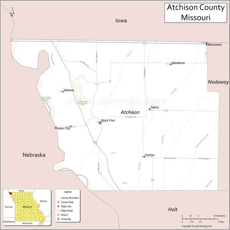
About Atchison County Map, Missouri: The map showing the county boundary, county seat, major cities, highways, water bodies and neighbouring counties.
Related Missouri Maps & Info
Atchison County, Missouri
Atchison County is a county located in the U.S. state of Missouri. It's county seat is Rock Port. As per 2020 census, the population of Atchison County is 5234 people and population density is square miles. According to the United States Census Bureau, the county has a total area of 545 sq mi (1,412 km2). Atchison County was established on 1843.
Atchison County Facts
| Continent | North America |
| Country | United States |
| State | Missouri |
| County Seat | Rock Port |
| Largest City/Town | Tarkio |
| Established | 1845 |
| Total Area | 550 sq mi (1,425 sq km) |
| Land Area | 545 sq mi (1,411 sq km) |
| Water Area | 5 sq mi (13 sq km) |
| Population | 5,305 (Census 2020) |
| Population Density | 9.7 people per sq mi |
| Time Zone | Central Time Zone (CST/CDT) |
| Major Highways | Interstate 29, U.S. Route 136, Missouri Route 111 |
| Major Rivers | Missouri River, Nishnabotna River nearby region |
| Neighboring Counties | Holt County, Nodaway County |
| Famous For | Missouri River floodplains, wind energy production, agriculture, and Lewis and Clark history |
| Top Attractions | Loess Bluffs National Wildlife Refuge nearby region, Tarkio Prairie, Lewis and Clark historic sites, and downtown Rock Port |
| Official Website | Official Website |
About Atchison County
Atchison County is located in the extreme northwestern corner of Missouri in the central United States and was established in 1845. The county seat is Rock Port, while Tarkio is the largest city. The county is known for fertile agricultural lands, Missouri River history, prairie conservation areas, and renewable wind energy development.
Cities and Towns in Atchison County, Missouri
| City/Town | Population (Census 2020) | Latitude & Longitude |
|---|---|---|
| Tarkio | 1,492 | 40.4408°N, 95.3772°W |
| Rock Port (county seat) | 1,252 | 40.4119°N, 95.5169°W |
| Fairfax | 609 | 40.3395°N, 95.3933°W |
| Westboro | 69 | 40.5339°N, 95.3230°W |
| Watson | 74 | 40.4786°N, 95.6211°W |
| Langdon | 42 | 40.4561°N, 95.2868°W |
What are the Golf Courses in Atchison County
| Golf Course | Location | Latitude & Longitude |
|---|---|---|
| Tarkio Golf Club | Tarkio | 40.4479°N, 95.3835°W |
| Rock Port Country Club | Rock Port | 40.4183°N, 95.5238°W |
Major Roads and Highways in Atchison County
Major highways connect the county with northwest Missouri communities and neighboring Iowa and Nebraska regions.
- Interstate 29 - major north-south interstate through northwest Missouri
- U.S. Route 136 - important east-west transportation corridor
- Missouri Route 111 - regional route serving local agricultural communities
What are Neighboring Counties of Atchison County
- Nodaway County (east)
- Holt County (south)
What Are the Top Attractions in Atchison County
The county offers a mix of prairie scenery, wildlife habitats, and Missouri River history.
- Loess Bluffs National Wildlife Refuge nearby region - birdwatching and wetland wildlife destination
- Tarkio Prairie - preserved tallgrass prairie ecosystem with native plant species
- Lewis and Clark Historic Sites - landmarks connected to the expedition along the Missouri River
- Downtown Rock Port - historic buildings, local shops, and community events
- Tarkio College Historic Area - former college campus with regional historical significance
- Missouri River Floodplain Landscapes - scenic agricultural valleys and wildlife habitats
- Wind Energy Viewing Areas - large wind turbine installations across the prairie countryside
- Fairfax Community Parks - local recreation and picnic areas
- Northwest Missouri Scenic Drives - rolling farmland and open prairie routes
- Fishing and Hunting Areas - outdoor recreation opportunities throughout the county
What Is the Distance from Atchison County to Nearby Cities
The following distances are measured by road (driving).
- Rock Port to St. Joseph (Buchanan County), Missouri - 78 mi (126 km)
- Rock Port to Maryville (Nodaway County), Missouri - 52 mi (84 km)
- Rock Port to Omaha (Douglas County), Nebraska - 93 mi (150 km)
- Rock Port to Lincoln (Lancaster County), Nebraska - 95 mi (153 km)
- Rock Port to Kansas City (Jackson County), Missouri - 120 mi (193 km)
- Rock Port to Tarkio (Atchison County), Missouri - 8 mi (13 km)
- Rock Port to Fairfax (Atchison County), Missouri - 16 mi (26 km)
- Rock Port to Des Moines (Polk County), Iowa - 149 mi (240 km)
- Rock Port to Columbia (Boone County), Missouri - 229 mi (369 km)
- Rock Port to Wichita (Sedgwick County), Kansas - 283 mi (455 km)
- Rock Port to Saint Louis (St. Louis City), Missouri - 382 mi (615 km)
- Rock Port to Minneapolis (Hennepin County), Minnesota - 398 mi (641 km)
- Rock Port to Denver (Denver County), Colorado - 550 mi (885 km)
FAQs about Atchison County
Atchison County is located in the northwestern corner of Missouri along the Missouri River.
Atchison County had a population of 5,305 according to the 2020 United States Census.
Atchison County is known for agriculture, prairie conservation, Missouri River history, and wind energy production.
The county is served by Interstate 29, U.S. Route 136, and Missouri Route 111.
Yes, Atchison County includes golf facilities such as Tarkio Golf Club and Rock Port Country Club.
References
- QuickFacts - U.S. Census Bureau
- United States Census Bureau
- United States Geological Survey (USGS)
- National Geodetic Survey
- Official Website
- Adair County Map
- Andrew County Map
- Atchison County Map
- Audrain County Map
- Barry County Map
- Barton County Map
- Bates County Map
- Benton County Map
- Bollinger County Map
- Boone County Map
- Buchanan County Map
- Butler County Map
- Caldwell County Map
- Callaway County Map
- Camden County Map
- Cape Girardeau County Map
- Carroll County Map
- Carter County Map
- Cass County Map
- Cedar County Map
- Chariton County Map
- Christian County Map
- Clark County Map
- Clay County Map
- Clinton County Map
- Cole County Map
- Cooper County Map
- Crawford County Map
- Dade County Map
- Dallas County Map
- Daviess County Map
- DeKalb County Map
- Dent County Map
- Douglas County Map
- Dunklin County Map
- Franklin County Map
- Gasconade County Map
- Gentry County Map
- Greene County Map
- Grundy County Map
- Harrison County Map
- Henry County Map
- Hickory County Map
- Holt County Map
- Howard County Map
- Howell County Map
- Iron County Map
- Jackson County Map
- Jasper County Map
- Jefferson County Map
- Johnson County Map
- Knox County Map
- Laclede County Map
- Lafayette County Map
- Lawrence County Map
- Lewis County Map
- Lincoln County Map
- Linn County Map
- Livingston County Map
- McDonald County Map
- Macon County Map
- Madison County Map
- Maries County Map
- Marion County Map
- Mercer County Map
- Miller County Map
- Mississippi County Map
- Moniteau County Map
- Monroe County Map
- Montgomery County Map
- Morgan County Map
- New Madrid County Map
- Newton County Map
- Nodaway County Map
- Oregon County Map
- Osage County Map
- Ozark County Map
- Pemiscot County Map
- Perry County Map
- Pettis County Map
- Phelps County Map
- Pike County Map
- Platte County Map
- Polk County Map
- Pulaski County Map
- Putnam County Map
- Ralls County Map
- Randolph County Map
- Ray County Map
- Reynolds County Map
- Ripley County Map
- St Charles County Map
- St Clair County Map
- Ste Genevieve County Map
- St Francois County Map
- St Louis County Map
- Saline County Map
- Schuyler County Map
- Scotland County Map
- Scott County Map
- Shannon County Map
- Shelby County Map
- Stoddard County Map
- Stone County Map
- Sullivan County Map
- Taney County Map
- Texas County Map
- Vernon County Map
- Warren County Map
- Washington County Map
- Wayne County Map
- Webster County Map
- Worth County Map
- Wright County Map
- St Louis County Map
- Alabama Counties
- Alaska boroughs
- Arizona Counties
- Arkansas Counties
- California County Map
- Colorado Counties
- Connecticut Counties
- Delaware Counties
- Florida County Map
- Georgia County Map
- Hawaii Counties
- Idaho Counties
- Illinois Counties
- Indiana Counties
- Iowa Counties
- Kansas Counties
- Kentucky Counties
- Louisiana Counties
- Maine Counties
- Maryland Counties
- Massachusetts Counties
- Michigan County Map
- Minnesota Counties
- Mississippi Counties
- Missouri Counties
- Montana Counties
- Nebraska Counties
- Nevada Counties
- New York Counties
- New Hampshire Counties
- New Jersey Counties
- New Mexico Counties
- North Carolina Counties
- North Dakota Counties
- Ohio County Map
- Oklahoma Counties
- Oregon Counties
- Pennsylvania Counties
- Rhode Island Counties
- South Carolina Counties
- South Dakota Counties
- Map of Tennessee
- Texas County Map
- Utah Counties
- Vermont Counties
- Virginia Counties
- Washington Counties
- West Virginia Counties
- Wisconsin Counties
- Wyoming Counties