Map of Saint Louis County - Saint Louis County is a county located in the U.S. state of Missouri. Saint Louis County Map showing cities, highways, important places and water bodies. Get Where is Saint Louis County located in the map, major cities in Saint Louis county, population, areas, and places of interest.
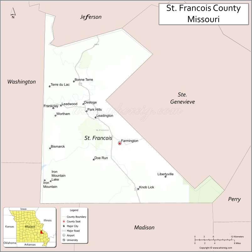
Map of St Francois County, Missouri
About Saint Louis County Map, Missouri: The map showing the county boundary, county seat, major cities, highways, water bodies and neighbouring counties.
Related Missouri Maps & Info
St Francois County, Missouri
Shannon County is a county located in the U.S. state of Missouri. It`s county seat is Eminence. As per 2020 census, the population of Shannon County was 7106 and population density of Shannon was square miles. According to the United States Census Bureau, the county has a total area of 1,004 sq mi (2,600 km2). Shannon County was established on 1837.
St. Francois County Facts
| Continent | North America |
| Country | United States |
| State | Missouri |
| County Seat | Farmington |
| Largest City/Town | Farmington |
| Established | 1821 |
| Total Area | 452 sq mi (1,171 sq km) |
| Land Area | 448 sq mi (1,160 sq km) |
| Water Area | 4 sq mi (11 sq km) |
| Population | 67,935 (Census 2020) |
| Population Density | 151.6 people per sq mi |
| Time Zone | Central Time Zone (CST/CDT) |
| Major Highways | U.S. Route 67, U.S. Route 67 Business, Missouri Route 32, Missouri Route 221 |
| Major Rivers | Big River, St. Francois River nearby region |
| Neighboring Counties | Ste. Genevieve County, Madison County, Washington County, Iron County, Jefferson County |
| Famous For | Mining history, Farmington, parks, wineries, and Ozark foothill scenery |
| Top Attractions | St. Joe State Park, Crown Valley Winery, Bonne Terre Mine, and historic downtown Farmington |
| Official Website | Official Website |
About St. Francois County
St. Francois County is located in southeastern Missouri within the Ozark foothills and was established in 1821. The county seat and largest city is Farmington. The county is known for mining heritage, outdoor recreation, wineries, and scenic rolling hills.
Cities and Towns in St. Francois County, Missouri
| City/Town | Population (Census 2020) | Latitude & Longitude |
|---|---|---|
| Farmington (county seat) | 18,217 | 37.7809°N, 90.4218°W |
| Park Hills | 8,221 | 37.8542°N, 90.5187°W |
| Desloge | 4,990 | 37.8714°N, 90.5271°W |
| Bonne Terre | 6,864 | 37.9237°N, 90.5557°W |
| Leadington | 698 | 37.8345°N, 90.4834°W |
| Bismarck | 1,207 | 37.7695°N, 90.6240°W |
What are the Golf Courses in St. Francois County
| Golf Course | Location | Latitude & Longitude |
|---|---|---|
| Crown Pointe Golf Club | Farmington | 37.8032°N, 90.4485°W |
| Farmington Country Club | Farmington | 37.7901°N, 90.4324°W |
| Bonne Terre Recreation Golf Area | Bonne Terre | 37.9365°N, 90.5692°W |
Major Roads and Highways in St. Francois County
Major highways connect St. Francois County with St. Louis and southeastern Missouri communities.
- U.S. Route 67 - major north-south transportation corridor through eastern Missouri
- U.S. Route 67 Business - local access route through Farmington and nearby communities
- Missouri Route 32 - east-west connector serving parks and rural areas
- Missouri Route 221 - regional highway linking towns and recreational areas
What are Neighboring Counties of St. Francois County
- Jefferson County (north)
- Ste. Genevieve County (east)
- Madison County (south)
- Iron County (southwest)
- Washington County (west)
What Are the Top Attractions in St. Francois County
The county offers parks, mines, wineries, scenic landscapes, and outdoor recreation opportunities.
- St. Joe State Park - ATV trails, lakes, camping, and outdoor recreation
- Bonne Terre Mine - underground lake tours and scuba diving attraction
- Crown Valley Winery - wine tasting, scenic vineyards, and events
- Historic Downtown Farmington - shops, restaurants, and cultural attractions
- Pickle Springs and Hickory Canyons nearby region - hiking and natural scenery
- Ozark Foothills Scenic Drives - rolling hills and countryside photography opportunities
- Community Festivals and Heritage Events - seasonal entertainment and local traditions
- Fishing Lakes and Recreation Areas - family-friendly outdoor activities
- Historic Mining Heritage Sites - preserved mining culture and museums
- Parks and Walking Trails - nature observation and relaxation spaces
What Is the Distance from St. Francois County to Nearby Cities
The following distances are measured by road (driving).
- Farmington to St. Louis (St. Louis City), Missouri - 72 mi (116 km)
- Farmington to Cape Girardeau (Cape Girardeau County), Missouri - 96 mi (154 km)
- Farmington to Poplar Bluff (Butler County), Missouri - 110 mi (177 km)
- Farmington to Rolla (Phelps County), Missouri - 85 mi (137 km)
- Farmington to Park Hills (St. Francois County), Missouri - 8 mi (13 km)
- Farmington to Bonne Terre (St. Francois County), Missouri - 12 mi (19 km)
- Farmington to Springfield (Greene County), Missouri - 214 mi (344 km)
- Farmington to Kansas City (Jackson County), Missouri - 282 mi (454 km)
- Farmington to Chicago (Cook County), Illinois - 357 mi (575 km)
- Farmington to Nashville (Davidson County), Tennessee - 321 mi (517 km)
- Farmington to Memphis (Shelby County), Tennessee - 279 mi (449 km)
- Farmington to Dallas (Dallas County), Texas - 624 mi (1,004 km)
- Farmington to Denver (Denver County), Colorado - 860 mi (1,384 km)
FAQs about St. Francois County
St. Francois County is located in southeastern Missouri within the Ozark foothills.
St. Francois County had a population of 67,935 according to the 2020 United States Census.
St. Francois County is known for mining history, parks, wineries, and scenic Ozark foothill landscapes.
The county is served by U.S. Route 67, U.S. Route 67 Business, Missouri Route 32, and Missouri Route 221.
Yes, St. Francois County includes golf facilities such as Crown Pointe Golf Club and Farmington Country Club.
References
- QuickFacts - U.S. Census Bureau
- United States Census Bureau
- United States Geological Survey (USGS)
- National Geodetic Survey
- Official Website
- Adair County Map
- Andrew County Map
- Atchison County Map
- Audrain County Map
- Barry County Map
- Barton County Map
- Bates County Map
- Benton County Map
- Bollinger County Map
- Boone County Map
- Buchanan County Map
- Butler County Map
- Caldwell County Map
- Callaway County Map
- Camden County Map
- Cape Girardeau County Map
- Carroll County Map
- Carter County Map
- Cass County Map
- Cedar County Map
- Chariton County Map
- Christian County Map
- Clark County Map
- Clay County Map
- Clinton County Map
- Cole County Map
- Cooper County Map
- Crawford County Map
- Dade County Map
- Dallas County Map
- Daviess County Map
- DeKalb County Map
- Dent County Map
- Douglas County Map
- Dunklin County Map
- Franklin County Map
- Gasconade County Map
- Gentry County Map
- Greene County Map
- Grundy County Map
- Harrison County Map
- Henry County Map
- Hickory County Map
- Holt County Map
- Howard County Map
- Howell County Map
- Iron County Map
- Jackson County Map
- Jasper County Map
- Jefferson County Map
- Johnson County Map
- Knox County Map
- Laclede County Map
- Lafayette County Map
- Lawrence County Map
- Lewis County Map
- Lincoln County Map
- Linn County Map
- Livingston County Map
- McDonald County Map
- Macon County Map
- Madison County Map
- Maries County Map
- Marion County Map
- Mercer County Map
- Miller County Map
- Mississippi County Map
- Moniteau County Map
- Monroe County Map
- Montgomery County Map
- Morgan County Map
- New Madrid County Map
- Newton County Map
- Nodaway County Map
- Oregon County Map
- Osage County Map
- Ozark County Map
- Pemiscot County Map
- Perry County Map
- Pettis County Map
- Phelps County Map
- Pike County Map
- Platte County Map
- Polk County Map
- Pulaski County Map
- Putnam County Map
- Ralls County Map
- Randolph County Map
- Ray County Map
- Reynolds County Map
- Ripley County Map
- St Charles County Map
- St Clair County Map
- Ste Genevieve County Map
- St Francois County Map
- St Louis County Map
- Saline County Map
- Schuyler County Map
- Scotland County Map
- Scott County Map
- Shannon County Map
- Shelby County Map
- Stoddard County Map
- Stone County Map
- Sullivan County Map
- Taney County Map
- Texas County Map
- Vernon County Map
- Warren County Map
- Washington County Map
- Wayne County Map
- Webster County Map
- Worth County Map
- Wright County Map
- St Louis County Map
- Alabama Counties
- Alaska boroughs
- Arizona Counties
- Arkansas Counties
- California County Map
- Colorado Counties
- Connecticut Counties
- Delaware Counties
- Florida County Map
- Georgia County Map
- Hawaii Counties
- Idaho Counties
- Illinois Counties
- Indiana Counties
- Iowa Counties
- Kansas Counties
- Kentucky Counties
- Louisiana Counties
- Maine Counties
- Maryland Counties
- Massachusetts Counties
- Michigan County Map
- Minnesota Counties
- Mississippi Counties
- Missouri Counties
- Montana Counties
- Nebraska Counties
- Nevada Counties
- New York Counties
- New Hampshire Counties
- New Jersey Counties
- New Mexico Counties
- North Carolina Counties
- North Dakota Counties
- Ohio County Map
- Oklahoma Counties
- Oregon Counties
- Pennsylvania Counties
- Rhode Island Counties
- South Carolina Counties
- South Dakota Counties
- Map of Tennessee
- Texas County Map
- Utah Counties
- Vermont Counties
- Virginia Counties
- Washington Counties
- West Virginia Counties
- Wisconsin Counties
- Wyoming Counties