Map of Livingston County - Livingston County is a county located in the U.S. state of Missouri. Livingston County Map showing cities, highways, important places and water bodies. Get Where is Livingston County located in the map, major cities in Livingston county, population, areas, and places of interest.
Map of Livingston County, Missouri
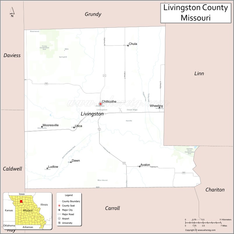
About Livingston County Map, Missouri: The map showing the county boundary, county seat, major cities, highways, water bodies and neighbouring counties.
Related Missouri Maps & Info
Livingston County, Missouri
Livingston County is a county located in the U.S. state of Missouri. It's county seat is Chillicothe. As per 2020 census, the population of Livingston County is 14755 people and population density is square miles. According to the United States Census Bureau, the county has a total area of 535 sq mi (1,386 km2). Livingston County was established on 1837.
Livingston County Facts
| Continent | North America |
| Country | United States |
| State | Missouri |
| County Seat | Chillicothe |
| Largest City/Town | Chillicothe |
| Established | 1837 |
| Total Area | 539 sq mi (1,396 sq km) |
| Land Area | 532 sq mi (1,378 sq km) |
| Water Area | 7 sq mi (18 sq km) |
| Population | 15,020 (Census 2020) |
| Population Density | 28.2 people per sq mi |
| Time Zone | Central Time Zone (CST/CDT) |
| Major Highways | U.S. Route 36, U.S. Route 65, Missouri Route 190, Missouri Route 190 |
| Major Rivers | Grand River, Thompson River nearby region |
| Neighboring Counties | Grundy County, Linn County, Caldwell County, Daviess County, Carroll County, Chariton County |
| Famous For | Chillicothe community, sliced bread history, agriculture, and outdoor recreation |
| Top Attractions | Home of Sliced Bread Museum, Grand River Historical Society Museum, Crowder State Park nearby region, and fishing lakes |
| Official Website | Official Website |
About Livingston County
Livingston County is located in north-central Missouri and was established in 1837. The county seat and largest city is Chillicothe. The county is known for its agriculture, railroad history, outdoor recreation, and being recognized as the “Home of Sliced Bread.”
Cities and Towns in Livingston County, Missouri
| City/Town | Population (Census 2020) | Latitude & Longitude |
|---|---|---|
| Chillicothe (county seat) | 9,190 | 39.7953°N, 93.5522°W |
| Ludlow | 137 | 39.6517°N, 93.6960°W |
| Wheeling | 220 | 39.7886°N, 93.3983°W |
| Utica | 222 | 39.7423°N, 93.6244°W |
| Mooresville | 91 | 39.7489°N, 93.6952°W |
| Chula | 210 | 39.9400°N, 93.4788°W |
What are the Golf Courses in Livingston County
| Golf Course | Location | Latitude & Longitude |
|---|---|---|
| Green Hills Golf Course | Chillicothe | 39.8058°N, 93.5659°W |
| Chillicothe Country Club | Chillicothe | 39.7891°N, 93.5424°W |
| Wheeling Recreation Golf Area | Wheeling | 39.7950°N, 93.4095°W |
Major Roads and Highways in Livingston County
Major highways connect Livingston County with Kansas City, northern Missouri, and regional agricultural trade centers.
- U.S. Route 36 - major east-west expressway across northern Missouri
- U.S. Route 65 - important north-south transportation corridor
- Missouri Route 190 - regional route serving local communities and farmland
What are Neighboring Counties of Livingston County
- Grundy County (east)
- Linn County (north)
- Caldwell County (west)
- Daviess County (southwest)
- Carroll County (south)
- Chariton County (southeast)
What Are the Top Attractions in Livingston County
The county offers museums, outdoor recreation, prairie scenery, and historical attractions.
- Home of Sliced Bread Museum - exhibits celebrating Chillicothe’s connection to sliced bread history
- Grand River Historical Society Museum - local heritage, railroad, and pioneer history exhibits
- Crowder State Park nearby region - hiking trails, camping, fishing, and horseback riding
- Chillicothe Downtown Historic District - murals, restaurants, and local shops
- Fishing Lakes and Recreation Areas - boating, camping, and family outdoor activities
- Grand River Scenic Areas - wildlife observation and photography locations
- Community Festivals and County Fair Events - agricultural traditions and seasonal celebrations
- Historic Rural Churches and Barns - preserved prairie heritage landmarks
- Prairie Scenic Drives - rolling farmland and countryside views
- Local Parks and Sports Facilities - recreation programs and family entertainment
What Is the Distance from Livingston County to Nearby Cities
The following distances are measured by road (driving).
- Chillicothe to Kansas City (Jackson County), Missouri - 93 mi (150 km)
- Chillicothe to St. Joseph (Buchanan County), Missouri - 91 mi (146 km)
- Chillicothe to Columbia (Boone County), Missouri - 122 mi (196 km)
- Chillicothe to Kirksville (Adair County), Missouri - 87 mi (140 km)
- Chillicothe to Wheeling (Livingston County), Missouri - 9 mi (14 km)
- Chillicothe to Utica (Livingston County), Missouri - 10 mi (16 km)
- Chillicothe to Jefferson City (Cole County), Missouri - 156 mi (251 km)
- Chillicothe to Des Moines (Polk County), Iowa - 181 mi (291 km)
- Chillicothe to Omaha (Douglas County), Nebraska - 201 mi (323 km)
- Chillicothe to St. Louis (St. Louis City), Missouri - 266 mi (428 km)
- Chillicothe to Chicago (Cook County), Illinois - 454 mi (731 km)
- Chillicothe to Minneapolis (Hennepin County), Minnesota - 389 mi (626 km)
- Chillicothe to Denver (Denver County), Colorado - 588 mi (946 km)
FAQs about Livingston County
Livingston County is located in north-central Missouri.
Livingston County had a population of 15,020 according to the 2020 United States Census.
Livingston County is known for Chillicothe, sliced bread history, agriculture, and outdoor recreation.
The county is served by U.S. Route 36, U.S. Route 65, and Missouri Route 190.
Yes, Livingston County includes golf facilities such as Green Hills Golf Course and Chillicothe Country Club.
References
- QuickFacts - U.S. Census Bureau
- United States Census Bureau
- United States Geological Survey (USGS)
- National Geodetic Survey
- Official Website
- Adair County Map
- Andrew County Map
- Atchison County Map
- Audrain County Map
- Barry County Map
- Barton County Map
- Bates County Map
- Benton County Map
- Bollinger County Map
- Boone County Map
- Buchanan County Map
- Butler County Map
- Caldwell County Map
- Callaway County Map
- Camden County Map
- Cape Girardeau County Map
- Carroll County Map
- Carter County Map
- Cass County Map
- Cedar County Map
- Chariton County Map
- Christian County Map
- Clark County Map
- Clay County Map
- Clinton County Map
- Cole County Map
- Cooper County Map
- Crawford County Map
- Dade County Map
- Dallas County Map
- Daviess County Map
- DeKalb County Map
- Dent County Map
- Douglas County Map
- Dunklin County Map
- Franklin County Map
- Gasconade County Map
- Gentry County Map
- Greene County Map
- Grundy County Map
- Harrison County Map
- Henry County Map
- Hickory County Map
- Holt County Map
- Howard County Map
- Howell County Map
- Iron County Map
- Jackson County Map
- Jasper County Map
- Jefferson County Map
- Johnson County Map
- Knox County Map
- Laclede County Map
- Lafayette County Map
- Lawrence County Map
- Lewis County Map
- Lincoln County Map
- Linn County Map
- Livingston County Map
- McDonald County Map
- Macon County Map
- Madison County Map
- Maries County Map
- Marion County Map
- Mercer County Map
- Miller County Map
- Mississippi County Map
- Moniteau County Map
- Monroe County Map
- Montgomery County Map
- Morgan County Map
- New Madrid County Map
- Newton County Map
- Nodaway County Map
- Oregon County Map
- Osage County Map
- Ozark County Map
- Pemiscot County Map
- Perry County Map
- Pettis County Map
- Phelps County Map
- Pike County Map
- Platte County Map
- Polk County Map
- Pulaski County Map
- Putnam County Map
- Ralls County Map
- Randolph County Map
- Ray County Map
- Reynolds County Map
- Ripley County Map
- St Charles County Map
- St Clair County Map
- Ste Genevieve County Map
- St Francois County Map
- St Louis County Map
- Saline County Map
- Schuyler County Map
- Scotland County Map
- Scott County Map
- Shannon County Map
- Shelby County Map
- Stoddard County Map
- Stone County Map
- Sullivan County Map
- Taney County Map
- Texas County Map
- Vernon County Map
- Warren County Map
- Washington County Map
- Wayne County Map
- Webster County Map
- Worth County Map
- Wright County Map
- St Louis County Map
- Alabama Counties
- Alaska boroughs
- Arizona Counties
- Arkansas Counties
- California County Map
- Colorado Counties
- Connecticut Counties
- Delaware Counties
- Florida County Map
- Georgia County Map
- Hawaii Counties
- Idaho Counties
- Illinois Counties
- Indiana Counties
- Iowa Counties
- Kansas Counties
- Kentucky Counties
- Louisiana Counties
- Maine Counties
- Maryland Counties
- Massachusetts Counties
- Michigan County Map
- Minnesota Counties
- Mississippi Counties
- Missouri Counties
- Montana Counties
- Nebraska Counties
- Nevada Counties
- New York Counties
- New Hampshire Counties
- New Jersey Counties
- New Mexico Counties
- North Carolina Counties
- North Dakota Counties
- Ohio County Map
- Oklahoma Counties
- Oregon Counties
- Pennsylvania Counties
- Rhode Island Counties
- South Carolina Counties
- South Dakota Counties
- Map of Tennessee
- Texas County Map
- Utah Counties
- Vermont Counties
- Virginia Counties
- Washington Counties
- West Virginia Counties
- Wisconsin Counties
- Wyoming Counties