Map of Cape Girardeau County - Cape Girardeau County is a county located in the U.S. state of Missouri. Cape Girardeau County Map showing cities, highways, important places and water bodies. Get Where is Cape Girardeau County located in the map, major cities in Cape Girardeau county, population, areas, and places of interest.
Map of Cape Girardeau County, Missouri
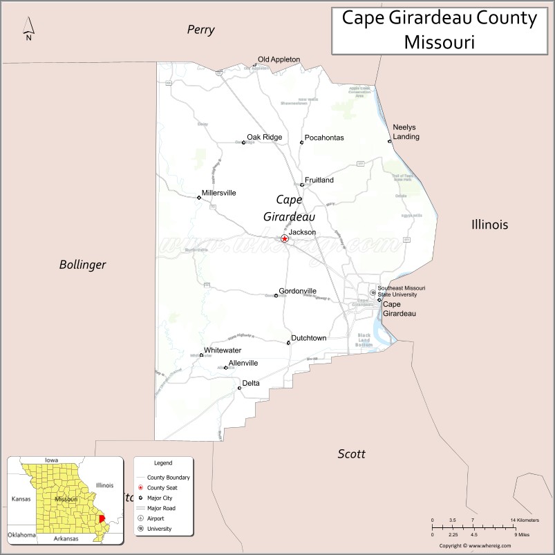
About Cape Girardeau County Map, Missouri: The map showing the county boundary, county seat, major cities, highways, water bodies and neighbouring counties.
Related Missouri Maps & Info
Cape Girardeau County, Missouri
Cape Girardeau County is a county located in the U.S. state of Missouri. It's county seat is Jackson. As per 2020 census, the population of Cape Girardeau County is 82113 people and population density is square miles. According to the United States Census Bureau, the county has a total area of 579 sq mi (1,500 km2). Cape Girardeau County was established on 1812.
Cape Girardeau County Facts
| Continent | North America |
| Country | United States |
| State | Missouri |
| County Seat | Jackson |
| Largest City/Town | Cape Girardeau |
| Established | 1812 |
| Total Area | 579 sq mi (1,500 sq km) |
| Land Area | 568 sq mi (1,471 sq km) |
| Water Area | 11 sq mi (28 sq km) |
| Population | 81,710 (Census 2020) |
| Population Density | 143.9 people per sq mi |
| Time Zone | Central Time Zone (CST/CDT) |
| Major Highways | Interstate 55, U.S. Route 61, U.S. Route 67, Missouri Route 25 |
| Major Rivers | Mississippi River, Whitewater River nearby region |
| Neighboring Counties | Perry County, Bollinger County, Stoddard County, Scott County |
| Famous For | Mississippi River heritage, Southeast Missouri State University, historic downtown Cape Girardeau, and riverfront attractions |
| Top Attractions | Cape Riverfront, Trail of Tears State Park, Southeast Missouri State University, and Glenn House |
| Official Website | Official Website |
About Cape Girardeau County
Cape Girardeau County is located in southeastern Missouri along the Mississippi River and was established in 1812. The county seat is Jackson, while Cape Girardeau is the largest city. The county is known for its riverfront history, higher education, cultural attractions, outdoor recreation, and role as a major regional center in southeast Missouri.
Cities and Towns in Cape Girardeau County, Missouri
| City/Town | Population (Census 2020) | Latitude & Longitude |
|---|---|---|
| Cape Girardeau | 39,540 | 37.3059°N, 89.5181°W |
| Jackson (county seat) | 15,481 | 37.3823°N, 89.6662°W |
| Scott City (partly in county) | 4,216 | 37.2167°N, 89.5240°W |
| Oak Ridge | 243 | 37.5076°N, 89.7301°W |
| Delta | 438 | 37.1801°N, 89.7354°W |
| Gordonville | 625 | 37.3128°N, 89.6798°W |
What are the Golf Courses in Cape Girardeau County
| Golf Course | Location | Latitude & Longitude |
|---|---|---|
| Dalhousie Golf Club | Cape Girardeau | 37.3625°N, 89.5932°W |
| Cape Country Club | Cape Girardeau | 37.3274°N, 89.5731°W |
| Bent Creek Golf Course | Jackson | 37.3908°N, 89.6819°W |
Major Roads and Highways in Cape Girardeau County
Major highways connect the county with St. Louis, Memphis, and important Mississippi River transportation corridors.
- Interstate 55 - major north-south interstate through eastern Missouri
- U.S. Route 61 - historic highway along the Mississippi River corridor
- U.S. Route 67 - important transportation route linking Missouri and Arkansas
- Missouri Route 25 - regional highway serving southeastern Missouri communities
What are Neighboring Counties of Cape Girardeau County
- Perry County (north)
- Bollinger County (west)
- Stoddard County (southwest)
- Scott County (south)
What Are the Top Attractions in Cape Girardeau County
The county offers a mix of riverfront attractions, historic landmarks, parks, and cultural destinations.
- Cape Riverfront - Mississippi River views, murals, trails, and entertainment districts
- Trail of Tears State Park - hiking, camping, river overlooks, and Native American history
- Southeast Missouri State University - historic campus, museums, sports, and cultural events
- Glenn House - restored Victorian mansion and historic museum
- Red House Interpretive Center - exhibits on regional history and the Trail of Tears
- Downtown Cape Girardeau - restaurants, shops, murals, and nightlife
- Discovery Playhouse - children’s museum and educational exhibits
- Missouri Wall of Fame - public art and historical tributes along the riverfront
- Capaha Park - sports fields, walking trails, and recreational facilities
- Riverfront Scenic Drives - Mississippi River landscapes and historic communities
What Is the Distance from Cape Girardeau County to Nearby Cities
The following distances are measured by road (driving).
- Cape Girardeau to Saint Louis (St. Louis City), Missouri - 115 mi (185 km)
- Cape Girardeau to Memphis (Shelby County), Tennessee - 170 mi (274 km)
- Cape Girardeau to Paducah (McCracken County), Kentucky - 70 mi (113 km)
- Cape Girardeau to Poplar Bluff (Butler County), Missouri - 112 mi (180 km)
- Cape Girardeau to Jackson (Cape Girardeau County), Missouri - 8 mi (13 km)
- Cape Girardeau to Scott City (Scott County), Missouri - 7 mi (11 km)
- Cape Girardeau to Springfield (Greene County), Missouri - 240 mi (386 km)
- Cape Girardeau to Nashville (Davidson County), Tennessee - 258 mi (415 km)
- Cape Girardeau to Kansas City (Jackson County), Missouri - 289 mi (465 km)
- Cape Girardeau to Chicago (Cook County), Illinois - 363 mi (584 km)
- Cape Girardeau to Little Rock (Pulaski County), Arkansas - 265 mi (426 km)
- Cape Girardeau to Louisville (Jefferson County), Kentucky - 254 mi (409 km)
- Cape Girardeau to Denver (Denver County), Colorado - 799 mi (1,286 km)
FAQs about Cape Girardeau County
Cape Girardeau County is located in southeastern Missouri along the Mississippi River.
Cape Girardeau County had a population of 81,710 according to the 2020 United States Census.
Cape Girardeau County is known for Mississippi River history, Southeast Missouri State University, and riverfront attractions.
The county is served by Interstate 55, U.S. Route 61, U.S. Route 67, and Missouri Route 25.
Yes, Cape Girardeau County includes golf facilities such as Dalhousie Golf Club, Cape Country Club, and Bent Creek Golf Course.
References
- QuickFacts - U.S. Census Bureau
- United States Census Bureau
- United States Geological Survey (USGS)
- National Geodetic Survey
- Official Website
- Adair County Map
- Andrew County Map
- Atchison County Map
- Audrain County Map
- Barry County Map
- Barton County Map
- Bates County Map
- Benton County Map
- Bollinger County Map
- Boone County Map
- Buchanan County Map
- Butler County Map
- Caldwell County Map
- Callaway County Map
- Camden County Map
- Cape Girardeau County Map
- Carroll County Map
- Carter County Map
- Cass County Map
- Cedar County Map
- Chariton County Map
- Christian County Map
- Clark County Map
- Clay County Map
- Clinton County Map
- Cole County Map
- Cooper County Map
- Crawford County Map
- Dade County Map
- Dallas County Map
- Daviess County Map
- DeKalb County Map
- Dent County Map
- Douglas County Map
- Dunklin County Map
- Franklin County Map
- Gasconade County Map
- Gentry County Map
- Greene County Map
- Grundy County Map
- Harrison County Map
- Henry County Map
- Hickory County Map
- Holt County Map
- Howard County Map
- Howell County Map
- Iron County Map
- Jackson County Map
- Jasper County Map
- Jefferson County Map
- Johnson County Map
- Knox County Map
- Laclede County Map
- Lafayette County Map
- Lawrence County Map
- Lewis County Map
- Lincoln County Map
- Linn County Map
- Livingston County Map
- McDonald County Map
- Macon County Map
- Madison County Map
- Maries County Map
- Marion County Map
- Mercer County Map
- Miller County Map
- Mississippi County Map
- Moniteau County Map
- Monroe County Map
- Montgomery County Map
- Morgan County Map
- New Madrid County Map
- Newton County Map
- Nodaway County Map
- Oregon County Map
- Osage County Map
- Ozark County Map
- Pemiscot County Map
- Perry County Map
- Pettis County Map
- Phelps County Map
- Pike County Map
- Platte County Map
- Polk County Map
- Pulaski County Map
- Putnam County Map
- Ralls County Map
- Randolph County Map
- Ray County Map
- Reynolds County Map
- Ripley County Map
- St Charles County Map
- St Clair County Map
- Ste Genevieve County Map
- St Francois County Map
- St Louis County Map
- Saline County Map
- Schuyler County Map
- Scotland County Map
- Scott County Map
- Shannon County Map
- Shelby County Map
- Stoddard County Map
- Stone County Map
- Sullivan County Map
- Taney County Map
- Texas County Map
- Vernon County Map
- Warren County Map
- Washington County Map
- Wayne County Map
- Webster County Map
- Worth County Map
- Wright County Map
- St Louis County Map
- Alabama Counties
- Alaska boroughs
- Arizona Counties
- Arkansas Counties
- California County Map
- Colorado Counties
- Connecticut Counties
- Delaware Counties
- Florida County Map
- Georgia County Map
- Hawaii Counties
- Idaho Counties
- Illinois Counties
- Indiana Counties
- Iowa Counties
- Kansas Counties
- Kentucky Counties
- Louisiana Counties
- Maine Counties
- Maryland Counties
- Massachusetts Counties
- Michigan County Map
- Minnesota Counties
- Mississippi Counties
- Missouri Counties
- Montana Counties
- Nebraska Counties
- Nevada Counties
- New York Counties
- New Hampshire Counties
- New Jersey Counties
- New Mexico Counties
- North Carolina Counties
- North Dakota Counties
- Ohio County Map
- Oklahoma Counties
- Oregon Counties
- Pennsylvania Counties
- Rhode Island Counties
- South Carolina Counties
- South Dakota Counties
- Map of Tennessee
- Texas County Map
- Utah Counties
- Vermont Counties
- Virginia Counties
- Washington Counties
- West Virginia Counties
- Wisconsin Counties
- Wyoming Counties