Map of Pemiscot County - Pemiscot County is a county located in the U.S. state of Missouri. Pemiscot County Map showing cities, highways, important places and water bodies. Get Where is Pemiscot County located in the map, major cities in Pemiscot county, population, areas, and places of interest.
Map of Pemiscot County, Missouri
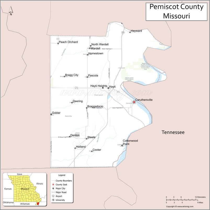
About Pemiscot County Map, Missouri: The map showing the county boundary, county seat, major cities, highways, water bodies and neighbouring counties.
Related Missouri Maps & Info
Pemiscot County, Missouri
Pemiscot County is a county located in the U.S. state of Missouri. It's county seat is Caruthersville. As per 2020 census, the population of Pemiscot County is 15236 people and population density is square miles. According to the United States Census Bureau, the county has a total area of 493 sq mi (1,277 km2). Pemiscot County was established on 1851.
Pemiscot County Facts
| Continent | North America |
| Country | United States |
| State | Missouri |
| County Seat | Caruthersville |
| Largest City/Town | Caruthersville |
| Established | 1851 |
| Total Area | 513 sq mi (1,329 sq km) |
| Land Area | 474 sq mi (1,228 sq km) |
| Water Area | 39 sq mi (101 sq km) |
| Population | 16,425 (Census 2020) |
| Population Density | 34.7 people per sq mi |
| Time Zone | Central Time Zone (CST/CDT) |
| Major Highways | Interstate 155, U.S. Route 412 nearby region, Missouri Route 84, Missouri Route 53 |
| Major Rivers | Mississippi River, Little River |
| Neighboring Counties | New Madrid County, Dunklin County, Dyer County (Tennessee), Lake County (Tennessee) |
| Famous For | Mississippi River commerce, agriculture, riverboat gaming, and Missouri Bootheel history |
| Top Attractions | Lady Luck Casino, Mississippi River waterfront, Caruthersville historic district, and river recreation areas |
| Official Website | Official Website |
About Pemiscot County
Pemiscot County is located in the southeastern Missouri Bootheel along the Mississippi River and was established in 1851. The county seat and largest city is Caruthersville. The county is known for agriculture, Mississippi River transportation history, riverfront recreation, and regional entertainment attractions.
Cities and Towns in Pemiscot County, Missouri
| City/Town | Population (Census 2020) | Latitude & Longitude |
|---|---|---|
| Caruthersville (county seat) | 5,039 | 36.1867°N, 89.6556°W |
| Hayti | 2,493 | 36.2337°N, 89.7493°W |
| Hayti Heights | 523 | 36.2320°N, 89.7480°W |
| Steele | 1,935 | 36.0848°N, 89.8295°W |
| Wardell | 427 | 36.3551°N, 89.8173°W |
| Cooter | 274 | 36.0487°N, 89.8129°W |
What are the Golf Courses in Pemiscot County
| Golf Course | Location | Latitude & Longitude |
|---|---|---|
| Caruthersville Country Club | Caruthersville | 36.1981°N, 89.6672°W |
| Hayti Recreation Golf Area | Hayti | 36.2449°N, 89.7618°W |
| Bootheel Regional Golf Course nearby region | Pemiscot County area | 36.1717°N, 89.7428°W |
Major Roads and Highways in Pemiscot County
Major highways connect Pemiscot County with Tennessee, Arkansas, and the Mississippi River transportation corridor.
- Interstate 155 - important interstate connection between Missouri and Tennessee
- U.S. Route 412 nearby region - regional east-west transportation corridor
- Missouri Route 84 - highway serving Bootheel agricultural communities
- Missouri Route 53 - connector route linking river towns and farmland regions
What are Neighboring Counties of Pemiscot County
- New Madrid County (north)
- Dunklin County (west)
- Dyer County, Tennessee (east)
- Lake County, Tennessee (southeast)
What Are the Top Attractions in Pemiscot County
The county offers riverfront attractions, entertainment venues, agricultural landscapes, and Mississippi River recreation.
- Lady Luck Casino - gaming, dining, and entertainment on the Mississippi River waterfront
- Mississippi River Scenic Areas - boating, fishing, and river photography locations
- Historic Downtown Caruthersville - local shops, architecture, and river heritage attractions
- Bootheel Agricultural Landscapes - fertile farmland and scenic Delta views
- Fishing and Outdoor Recreation Areas - camping, boating, and family activities
- Riverfront Parks and Picnic Areas - scenic relaxation and community gatherings
- Community Festivals and Heritage Events - seasonal celebrations and cultural traditions
- Wildlife Observation Areas - birdwatching and wetland habitats
- Historic Transportation Sites - exhibits on river commerce and regional history
- Nature Trails and Conservation Areas - outdoor exploration and environmental education
What Is the Distance from Pemiscot County to Nearby Cities
The following distances are measured by road (driving).
- Caruthersville to Memphis (Shelby County), Tennessee - 95 mi (153 km)
- Caruthersville to Sikeston (Scott County), Missouri - 76 mi (122 km)
- Caruthersville to Jonesboro (Craighead County), Arkansas - 70 mi (113 km)
- Caruthersville to Dyersburg (Dyer County), Tennessee - 15 mi (24 km)
- Caruthersville to Hayti (Pemiscot County), Missouri - 7 mi (11 km)
- Caruthersville to Steele (Pemiscot County), Missouri - 16 mi (26 km)
- Caruthersville to Little Rock (Pulaski County), Arkansas - 155 mi (249 km)
- Caruthersville to Nashville (Davidson County), Tennessee - 222 mi (357 km)
- Caruthersville to St. Louis (St. Louis City), Missouri - 236 mi (380 km)
- Caruthersville to Kansas City (Jackson County), Missouri - 434 mi (698 km)
- Caruthersville to Dallas (Dallas County), Texas - 447 mi (719 km)
- Caruthersville to Chicago (Cook County), Illinois - 446 mi (718 km)
- Caruthersville to Denver (Denver County), Colorado - 884 mi (1,423 km)
FAQs about Pemiscot County
Pemiscot County is located in the southeastern Missouri Bootheel along the Mississippi River.
Pemiscot County had a population of 16,425 according to the 2020 United States Census.
Pemiscot County is known for Mississippi River commerce, agriculture, and riverfront entertainment attractions.
The county is served by Interstate 155, nearby U.S. Route 412, Missouri Route 84, and Missouri Route 53.
Yes, Pemiscot County includes golf facilities such as Caruthersville Country Club and recreation golf areas near Hayti.
References
- QuickFacts - U.S. Census Bureau
- United States Census Bureau
- United States Geological Survey (USGS)
- National Geodetic Survey
- Official Website
- Adair County Map
- Andrew County Map
- Atchison County Map
- Audrain County Map
- Barry County Map
- Barton County Map
- Bates County Map
- Benton County Map
- Bollinger County Map
- Boone County Map
- Buchanan County Map
- Butler County Map
- Caldwell County Map
- Callaway County Map
- Camden County Map
- Cape Girardeau County Map
- Carroll County Map
- Carter County Map
- Cass County Map
- Cedar County Map
- Chariton County Map
- Christian County Map
- Clark County Map
- Clay County Map
- Clinton County Map
- Cole County Map
- Cooper County Map
- Crawford County Map
- Dade County Map
- Dallas County Map
- Daviess County Map
- DeKalb County Map
- Dent County Map
- Douglas County Map
- Dunklin County Map
- Franklin County Map
- Gasconade County Map
- Gentry County Map
- Greene County Map
- Grundy County Map
- Harrison County Map
- Henry County Map
- Hickory County Map
- Holt County Map
- Howard County Map
- Howell County Map
- Iron County Map
- Jackson County Map
- Jasper County Map
- Jefferson County Map
- Johnson County Map
- Knox County Map
- Laclede County Map
- Lafayette County Map
- Lawrence County Map
- Lewis County Map
- Lincoln County Map
- Linn County Map
- Livingston County Map
- McDonald County Map
- Macon County Map
- Madison County Map
- Maries County Map
- Marion County Map
- Mercer County Map
- Miller County Map
- Mississippi County Map
- Moniteau County Map
- Monroe County Map
- Montgomery County Map
- Morgan County Map
- New Madrid County Map
- Newton County Map
- Nodaway County Map
- Oregon County Map
- Osage County Map
- Ozark County Map
- Pemiscot County Map
- Perry County Map
- Pettis County Map
- Phelps County Map
- Pike County Map
- Platte County Map
- Polk County Map
- Pulaski County Map
- Putnam County Map
- Ralls County Map
- Randolph County Map
- Ray County Map
- Reynolds County Map
- Ripley County Map
- St Charles County Map
- St Clair County Map
- Ste Genevieve County Map
- St Francois County Map
- St Louis County Map
- Saline County Map
- Schuyler County Map
- Scotland County Map
- Scott County Map
- Shannon County Map
- Shelby County Map
- Stoddard County Map
- Stone County Map
- Sullivan County Map
- Taney County Map
- Texas County Map
- Vernon County Map
- Warren County Map
- Washington County Map
- Wayne County Map
- Webster County Map
- Worth County Map
- Wright County Map
- St Louis County Map
- Alabama Counties
- Alaska boroughs
- Arizona Counties
- Arkansas Counties
- California County Map
- Colorado Counties
- Connecticut Counties
- Delaware Counties
- Florida County Map
- Georgia County Map
- Hawaii Counties
- Idaho Counties
- Illinois Counties
- Indiana Counties
- Iowa Counties
- Kansas Counties
- Kentucky Counties
- Louisiana Counties
- Maine Counties
- Maryland Counties
- Massachusetts Counties
- Michigan County Map
- Minnesota Counties
- Mississippi Counties
- Missouri Counties
- Montana Counties
- Nebraska Counties
- Nevada Counties
- New York Counties
- New Hampshire Counties
- New Jersey Counties
- New Mexico Counties
- North Carolina Counties
- North Dakota Counties
- Ohio County Map
- Oklahoma Counties
- Oregon Counties
- Pennsylvania Counties
- Rhode Island Counties
- South Carolina Counties
- South Dakota Counties
- Map of Tennessee
- Texas County Map
- Utah Counties
- Vermont Counties
- Virginia Counties
- Washington Counties
- West Virginia Counties
- Wisconsin Counties
- Wyoming Counties