Map of Bollinger County - Bollinger County is a county located in the U.S. state of Missouri. Bollinger County Map showing cities, highways, important places and water bodies. Get Where is Bollinger County located in the map, major cities in Bollinger county, population, areas, and places of interest.
Map of Bollinger County, Missouri
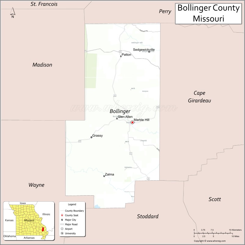
About Bollinger County Map, Missouri: The map showing the county boundary, county seat, major cities, highways, water bodies and neighbouring counties.
Related Missouri Maps & Info
Bollinger County, Missouri
Bollinger County is a county located in the U.S. state of Missouri. It's county seat is Marble Hill. As per 2020 census, the population of Bollinger County is 10556 people and population density is square miles. According to the United States Census Bureau, the county has a total area of 621 sq mi (1,608 km2). Bollinger County was established on 1851.
Bollinger County Facts
| Continent | North America |
| Country | United States |
| State | Missouri |
| County Seat | Marble Hill |
| Largest City/Town | Marble Hill |
| Established | 1851 |
| Total Area | 621 sq mi (1,608 sq km) |
| Land Area | 618 sq mi (1,601 sq km) |
| Water Area | 3 sq mi (8 sq km) |
| Population | 11,798 (Census 2020) |
| Population Density | 19.1 people per sq mi |
| Time Zone | Central Time Zone (CST/CDT) |
| Major Highways | Missouri Route 34, Missouri Route 51, Missouri Route 72 |
| Major Rivers | Castor River, Whitewater River nearby region |
| Neighboring Counties | Madison County, Cape Girardeau County, Perry County, Stoddard County, Wayne County |
| Famous For | Ozark foothills, rural scenery, hiking, and southeastern Missouri heritage |
| Top Attractions | Castor River Shut-Ins nearby region, Marble Hill historic district, Hurricane Creek Recreation Area, and Ozark National Scenic Riverways nearby areas |
| Official Website | Official Website |
About Bollinger County
Bollinger County is located in southeastern Missouri in the central United States and was established in 1851. The county seat and largest city is Marble Hill. The county is known for its Ozark foothill landscapes, rivers and streams, outdoor recreation opportunities, and quiet rural communities.
Cities and Towns in Bollinger County, Missouri
| City/Town | Population (Census 2020) | Latitude & Longitude |
|---|---|---|
| Marble Hill (county seat) | 1,356 | 37.3056°N, 89.9709°W |
| Zalma | 88 | 37.1448°N, 90.0751°W |
| Patton | 73 | 37.5000°N, 90.0118°W |
| Sedgewickville | 173 | 37.5226°N, 89.9187°W |
| Dongola nearby area | 121 | 37.3868°N, 90.0212°W |
| Grassy Community | 64 | 37.2375°N, 90.0624°W |
What are the Golf Courses in Bollinger County
| Golf Course | Location | Latitude & Longitude |
|---|---|---|
| Marble Hill Golf & Recreation Club | Marble Hill | 37.3117°N, 89.9781°W |
| Castor Valley Golf Area | Zalma | 37.1515°N, 90.0814°W |
Major Roads and Highways in Bollinger County
Major highways connect the county with southeastern Missouri communities and Ozark recreation regions.
- Missouri Route 34 - major east-west transportation route through the county
- Missouri Route 51 - north-south highway serving local communities
- Missouri Route 72 - scenic route linking Ozark foothill areas
What are Neighboring Counties of Bollinger County
- Perry County (north)
- Cape Girardeau County (east)
- Stoddard County (south)
- Wayne County (west)
- Madison County (northwest)
What Are the Top Attractions in Bollinger County
The county offers a mix of Ozark scenery, rivers, forests, and historical attractions.
- Castor River Shut-Ins nearby region - natural rock formations, swimming holes, and hiking areas
- Marble Hill Historic District - downtown shops, restaurants, and historic architecture
- Hurricane Creek Recreation Area - camping, hiking, fishing, and picnic opportunities
- Ozark National Scenic Riverways nearby areas - scenic rivers, caves, and forest landscapes
- Castor River Recreation Areas - kayaking, canoeing, and fishing destinations
- Bollinger County Museum of Natural History - local history and regional heritage exhibits
- Ozark Scenic Drives - rolling hills, forests, and countryside views
- Zalma Community Park - small-town recreation and picnic facilities
- Wildlife Observation Areas - habitats for deer, birds, and Ozark wildlife species
- Historic Churches and Rural Communities - preserved architecture and cultural heritage sites
What Is the Distance from Bollinger County to Nearby Cities
The following distances are measured by road (driving).
- Marble Hill to Cape Girardeau (Cape Girardeau County), Missouri - 33 mi (53 km)
- Marble Hill to Poplar Bluff (Butler County), Missouri - 66 mi (106 km)
- Marble Hill to Perryville (Perry County), Missouri - 42 mi (68 km)
- Marble Hill to Farmington (St. Francois County), Missouri - 59 mi (95 km)
- Marble Hill to Zalma (Bollinger County), Missouri - 16 mi (26 km)
- Marble Hill to Patton (Bollinger County), Missouri - 14 mi (23 km)
- Marble Hill to Saint Louis (St. Louis City), Missouri - 123 mi (198 km)
- Marble Hill to Memphis (Shelby County), Tennessee - 190 mi (306 km)
- Marble Hill to Springfield (Greene County), Missouri - 225 mi (362 km)
- Marble Hill to Little Rock (Pulaski County), Arkansas - 234 mi (377 km)
- Marble Hill to Nashville (Davidson County), Tennessee - 279 mi (449 km)
- Marble Hill to Kansas City (Jackson County), Missouri - 292 mi (470 km)
- Marble Hill to Chicago (Cook County), Illinois - 389 mi (626 km)
FAQs about Bollinger County
Bollinger County is located in southeastern Missouri in the Ozark foothills region.
Bollinger County had a population of 11,798 according to the 2020 United States Census.
Bollinger County is known for Ozark scenery, rivers, hiking, outdoor recreation, and rural heritage.
The county is served by Missouri Route 34, Missouri Route 51, and Missouri Route 72.
Yes, Bollinger County includes golf facilities such as Marble Hill Golf & Recreation Club and Castor Valley Golf Area.