Map of Butler County - Butler County is a county located in the U.S. state of Missouri. Butler County Map showing cities, highways, important places and water bodies. Get Where is Butler County located in the map, major cities in Butler county, population, areas, and places of interest.
Map of Butler County, Missouri
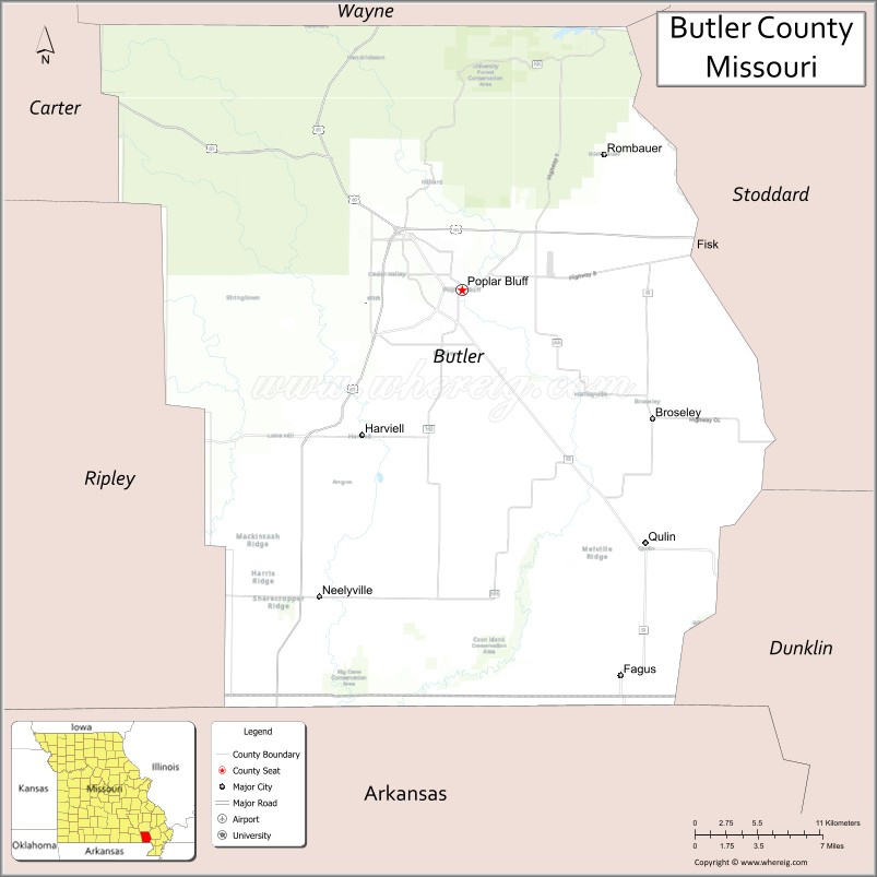
About Butler County Map, Missouri: The map showing the county boundary, county seat, major cities, highways, water bodies and neighbouring counties.
Related Missouri Maps & Info
Butler County, Missouri
Butler County is a county located in the U.S. state of Missouri. It's county seat is Poplar Bluff. As per 2020 census, the population of Butler County is 42101 people and population density is square miles. According to the United States Census Bureau, the county has a total area of 698 sq mi (1,808 km2). Butler County was established on 1849.
Butler County Facts
| Continent | North America |
| Country | United States |
| State | Missouri |
| County Seat | Poplar Bluff |
| Largest City/Town | Poplar Bluff |
| Established | 1849 |
| Total Area | 699 sq mi (1,810 sq km) |
| Land Area | 695 sq mi (1,800 sq km) |
| Water Area | 4 sq mi (10 sq km) |
| Population | 42,130 (Census 2020) |
| Population Density | 60.6 people per sq mi |
| Time Zone | Central Time Zone (CST/CDT) |
| Major Highways | U.S. Route 60, U.S. Route 67, Missouri Route 53, Missouri Route 142 |
| Major Rivers | Black River, Current River nearby region, St. Francis River nearby region |
| Neighboring Counties | Wayne County, Carter County, Ripley County, Stoddard County |
| Famous For | Ozark foothills, outdoor recreation, Poplar Bluff, and forest landscapes |
| Top Attractions | Mark Twain National Forest nearby areas, Black River recreation, Poplar Bluff Historic District, and Lake Wappapello nearby region |
| Official Website | Official Website |
About Butler County
Butler County is located in southeastern Missouri in the central United States and was established in 1849. The county seat and largest city is Poplar Bluff. The county is known for its Ozark foothill scenery, forests, rivers, outdoor recreation opportunities, and role as a regional commercial center in southeast Missouri.
Cities and Towns in Butler County, Missouri
| City/Town | Population (Census 2020) | Latitude & Longitude |
|---|---|---|
| Poplar Bluff (county seat) | 16,225 | 36.7569°N, 90.3929°W |
| Qulin | 695 | 36.5951°N, 90.2437°W |
| Fisk | 302 | 36.7873°N, 90.2062°W |
| Harviell | 255 | 36.6670°N, 90.4837°W |
| Broseley | 117 | 36.6681°N, 90.2451°W |
| Neelyville | 482 | 36.5587°N, 90.5071°W |
What are the Golf Courses in Butler County
| Golf Course | Location | Latitude & Longitude |
|---|---|---|
| Westwood Hills Country Club | Poplar Bluff | 36.7783°N, 90.4048°W |
| Ozark Ridge Golf Recreation Area | Poplar Bluff | 36.7496°N, 90.3844°W |
Major Roads and Highways in Butler County
Major highways connect the county with southeastern Missouri communities and regional recreation areas.
- U.S. Route 60 - major east-west transportation corridor through southern Missouri
- U.S. Route 67 - important north-south highway linking Missouri and Arkansas
- Missouri Route 53 - regional highway serving local communities
- Missouri Route 142 - scenic route across southeastern Missouri
What are Neighboring Counties of Butler County
- Wayne County (north)
- Stoddard County (east)
- Ripley County (southwest)
- Carter County (west)
What Are the Top Attractions in Butler County
The county offers a mix of Ozark scenery, forests, rivers, and outdoor recreation opportunities.
- Mark Twain National Forest nearby areas - hiking, camping, wildlife viewing, and scenic drives
- Black River Recreation Areas - fishing, kayaking, canoeing, and boating opportunities
- Poplar Bluff Historic District - downtown shops, restaurants, and historic architecture
- Lake Wappapello nearby region - boating, fishing, swimming, and camping destination
- Current River nearby area - floating, canoeing, and scenic Ozark landscapes
- Butler County Museum - exhibits on local history, railroads, and pioneer settlement
- Rodgers Theatre - restored historic theater hosting entertainment and community events
- Ozark Scenic Drives - rolling hills, forests, and river valley views
- Hendrickson Park - sports facilities, walking trails, and picnic areas
- Wildlife Observation Areas - habitats for deer, birds, and southeastern Missouri wildlife species
What Is the Distance from Butler County to Nearby Cities
The following distances are measured by road (driving).
- Poplar Bluff to Cape Girardeau (Cape Girardeau County), Missouri - 112 mi (180 km)
- Poplar Bluff to Springfield (Greene County), Missouri - 190 mi (306 km)
- Poplar Bluff to Jonesboro (Craighead County), Arkansas - 95 mi (153 km)
- Poplar Bluff to Sikeston (Scott County), Missouri - 70 mi (113 km)
- Poplar Bluff to Qulin (Butler County), Missouri - 16 mi (26 km)
- Poplar Bluff to Fisk (Butler County), Missouri - 14 mi (23 km)
- Poplar Bluff to Saint Louis (St. Louis City), Missouri - 150 mi (241 km)
- Poplar Bluff to Memphis (Shelby County), Tennessee - 165 mi (266 km)
- Poplar Bluff to Little Rock (Pulaski County), Arkansas - 190 mi (306 km)
- Poplar Bluff to Nashville (Davidson County), Tennessee - 284 mi (457 km)
- Poplar Bluff to Kansas City (Jackson County), Missouri - 320 mi (515 km)
- Poplar Bluff to Chicago (Cook County), Illinois - 437 mi (703 km)
- Poplar Bluff to Denver (Denver County), Colorado - 822 mi (1,323 km)
FAQs about Butler County
Butler County is located in southeastern Missouri in the Ozark foothills region.
Butler County had a population of 42,130 according to the 2020 United States Census.
Butler County is known for Ozark scenery, forests, rivers, outdoor recreation, and the city of Poplar Bluff.
The county is served by U.S. Route 60, U.S. Route 67, Missouri Route 53, and Missouri Route 142.
Yes, Butler County includes golf facilities such as Westwood Hills Country Club and Ozark Ridge Golf Recreation Area.
References
- QuickFacts - U.S. Census Bureau
- United States Census Bureau
- United States Geological Survey (USGS)
- National Geodetic Survey
- Official Website
- Adair County Map
- Andrew County Map
- Atchison County Map
- Audrain County Map
- Barry County Map
- Barton County Map
- Bates County Map
- Benton County Map
- Bollinger County Map
- Boone County Map
- Buchanan County Map
- Butler County Map
- Caldwell County Map
- Callaway County Map
- Camden County Map
- Cape Girardeau County Map
- Carroll County Map
- Carter County Map
- Cass County Map
- Cedar County Map
- Chariton County Map
- Christian County Map
- Clark County Map
- Clay County Map
- Clinton County Map
- Cole County Map
- Cooper County Map
- Crawford County Map
- Dade County Map
- Dallas County Map
- Daviess County Map
- DeKalb County Map
- Dent County Map
- Douglas County Map
- Dunklin County Map
- Franklin County Map
- Gasconade County Map
- Gentry County Map
- Greene County Map
- Grundy County Map
- Harrison County Map
- Henry County Map
- Hickory County Map
- Holt County Map
- Howard County Map
- Howell County Map
- Iron County Map
- Jackson County Map
- Jasper County Map
- Jefferson County Map
- Johnson County Map
- Knox County Map
- Laclede County Map
- Lafayette County Map
- Lawrence County Map
- Lewis County Map
- Lincoln County Map
- Linn County Map
- Livingston County Map
- McDonald County Map
- Macon County Map
- Madison County Map
- Maries County Map
- Marion County Map
- Mercer County Map
- Miller County Map
- Mississippi County Map
- Moniteau County Map
- Monroe County Map
- Montgomery County Map
- Morgan County Map
- New Madrid County Map
- Newton County Map
- Nodaway County Map
- Oregon County Map
- Osage County Map
- Ozark County Map
- Pemiscot County Map
- Perry County Map
- Pettis County Map
- Phelps County Map
- Pike County Map
- Platte County Map
- Polk County Map
- Pulaski County Map
- Putnam County Map
- Ralls County Map
- Randolph County Map
- Ray County Map
- Reynolds County Map
- Ripley County Map
- St Charles County Map
- St Clair County Map
- Ste Genevieve County Map
- St Francois County Map
- St Louis County Map
- Saline County Map
- Schuyler County Map
- Scotland County Map
- Scott County Map
- Shannon County Map
- Shelby County Map
- Stoddard County Map
- Stone County Map
- Sullivan County Map
- Taney County Map
- Texas County Map
- Vernon County Map
- Warren County Map
- Washington County Map
- Wayne County Map
- Webster County Map
- Worth County Map
- Wright County Map
- St Louis County Map
- Alabama Counties
- Alaska boroughs
- Arizona Counties
- Arkansas Counties
- California County Map
- Colorado Counties
- Connecticut Counties
- Delaware Counties
- Florida County Map
- Georgia County Map
- Hawaii Counties
- Idaho Counties
- Illinois Counties
- Indiana Counties
- Iowa Counties
- Kansas Counties
- Kentucky Counties
- Louisiana Counties
- Maine Counties
- Maryland Counties
- Massachusetts Counties
- Michigan County Map
- Minnesota Counties
- Mississippi Counties
- Missouri Counties
- Montana Counties
- Nebraska Counties
- Nevada Counties
- New York Counties
- New Hampshire Counties
- New Jersey Counties
- New Mexico Counties
- North Carolina Counties
- North Dakota Counties
- Ohio County Map
- Oklahoma Counties
- Oregon Counties
- Pennsylvania Counties
- Rhode Island Counties
- South Carolina Counties
- South Dakota Counties
- Map of Tennessee
- Texas County Map
- Utah Counties
- Vermont Counties
- Virginia Counties
- Washington Counties
- West Virginia Counties
- Wisconsin Counties
- Wyoming Counties