Map of Chariton County - Chariton County is a county located in the U.S. state of Missouri. Chariton County Map showing cities, highways, important places and water bodies. Get Where is Chariton County located in the map, major cities in Chariton county, population, areas, and places of interest.
Map of Chariton County, Missouri
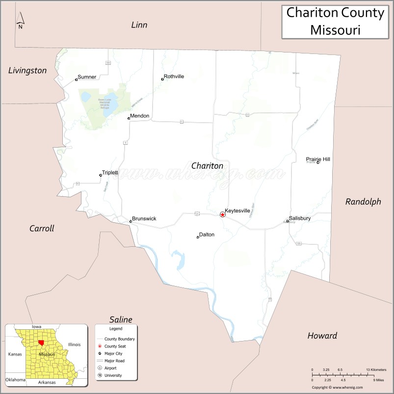
About Chariton County Map, Missouri: The map showing the county boundary, county seat, major cities, highways, water bodies and neighbouring counties.
Related Missouri Maps & Info
Chariton County, Missouri
Chariton County is a county located in the U.S. state of Missouri. It's county seat is Keytesville. As per 2020 census, the population of Chariton County is 7356 people and population density is square miles. According to the United States Census Bureau, the county has a total area of 756 sq mi (1,958 km2). Chariton County was established on 1821.
Chariton County Facts
| Continent | North America |
| Country | United States |
| State | Missouri |
| County Seat | Keytesville |
| Largest City/Town | Salisbury |
| Established | 1820 |
| Total Area | 756 sq mi (1,958 sq km) |
| Land Area | 752 sq mi (1,948 sq km) |
| Water Area | 4 sq mi (10 sq km) |
| Population | 7,408 (Census 2020) |
| Population Density | 9.8 people per sq mi |
| Time Zone | Central Time Zone (CST/CDT) |
| Major Highways | U.S. Route 24, Missouri Route 5, Missouri Route 11 |
| Major Rivers | Missouri River nearby region, Chariton River |
| Neighboring Counties | Linn County, Macon County, Randolph County, Howard County, Carroll County, Livingston County |
| Famous For | Agriculture, prairie landscapes, historic river communities, and Walt Disney family heritage nearby region |
| Top Attractions | Keytesville historic district, Chariton County Museum, Swan Lake National Wildlife Refuge nearby region, and Thomas Hill Lake nearby area |
| Official Website | Official Website |
About Chariton County
Chariton County is located in north-central Missouri in the United States and was established in 1820. The county seat is Keytesville, while Salisbury is the largest city. The county is known for agriculture, rural landscapes, historic river communities, wildlife areas, and its connection to early Missouri settlement history.
Cities and Towns in Chariton County, Missouri
| City/Town | Population (Census 2020) | Latitude & Longitude |
|---|---|---|
| Salisbury | 1,618 | 39.4231°N, 92.8013°W |
| Keytesville (county seat) | 440 | 39.4403°N, 92.9380°W |
| Brunswick | 801 | 39.4239°N, 93.1313°W |
| Mendon | 152 | 39.5875°N, 93.1285°W |
| Glasgow nearby region | 1,077 | 39.2270°N, 92.8466°W |
| Dalton | 7 | 39.3998°N, 92.9905°W |
What are the Golf Courses in Chariton County
| Golf Course | Location | Latitude & Longitude |
|---|---|---|
| Salisbury Country Club | Salisbury | 39.4314°N, 92.8096°W |
| Brunswick Recreation Golf Area | Brunswick | 39.4311°N, 93.1390°W |
Major Roads and Highways in Chariton County
Major highways connect the county with north-central Missouri communities and agricultural regions.
- U.S. Route 24 - important east-west transportation route across northern Missouri
- Missouri Route 5 - major north-south highway serving rural communities
- Missouri Route 11 - regional route linking small towns and farmland areas
What are Neighboring Counties of Chariton County
- Linn County (northwest)
- Macon County (northeast)
- Randolph County (east)
- Howard County (south)
- Carroll County (west)
- Livingston County (north)
What Are the Top Attractions in Chariton County
The county offers a mix of historical sites, wildlife areas, prairie scenery, and outdoor recreation.
- Keytesville Historic District - courthouse square, historic buildings, and local heritage attractions
- Chariton County Museum - exhibits on pioneer settlement, farming, and local history
- Swan Lake National Wildlife Refuge nearby region - birdwatching, wetlands, and wildlife habitats
- Thomas Hill Lake nearby area - boating, fishing, and camping destination
- Brunswick Historic Community - river history and scenic rural surroundings
- Chariton River Recreation Areas - fishing, kayaking, and nature observation
- North-Central Missouri Scenic Drives - prairie landscapes and rolling farmland
- Salisbury Community Parks - sports facilities, picnic areas, and walking trails
- Historic Rural Churches and Schoolhouses - preserved 19th-century architecture
- Community Festivals and County Fairs - seasonal events celebrating local heritage and agriculture
What Is the Distance from Chariton County to Nearby Cities
The following distances are measured by road (driving).
- Keytesville to Columbia (Boone County), Missouri - 71 mi (114 km)
- Keytesville to Kansas City (Jackson County), Missouri - 126 mi (203 km)
- Keytesville to Chillicothe (Livingston County), Missouri - 43 mi (69 km)
- Keytesville to Moberly (Randolph County), Missouri - 38 mi (61 km)
- Keytesville to Salisbury (Chariton County), Missouri - 15 mi (24 km)
- Keytesville to Brunswick (Chariton County), Missouri - 13 mi (21 km)
- Keytesville to Saint Louis (St. Louis City), Missouri - 197 mi (317 km)
- Keytesville to Des Moines (Polk County), Iowa - 198 mi (319 km)
- Keytesville to Omaha (Douglas County), Nebraska - 252 mi (406 km)
- Keytesville to Springfield (Greene County), Missouri - 192 mi (309 km)
- Keytesville to Chicago (Cook County), Illinois - 430 mi (692 km)
- Keytesville to Denver (Denver County), Colorado - 643 mi (1,035 km)
- Keytesville to Minneapolis (Hennepin County), Minnesota - 429 mi (690 km)
FAQs about Chariton County
Chariton County is located in north-central Missouri in the United States.
Chariton County had a population of 7,408 according to the 2020 United States Census.
Chariton County is known for agriculture, prairie landscapes, wildlife areas, and historic river communities.
The county is served by U.S. Route 24, Missouri Route 5, and Missouri Route 11.
Yes, Chariton County includes golf facilities such as Salisbury Country Club and Brunswick Recreation Golf Area.
References
- QuickFacts - U.S. Census Bureau
- United States Census Bureau
- United States Geological Survey (USGS)
- National Geodetic Survey
- Official Website
- Adair County Map
- Andrew County Map
- Atchison County Map
- Audrain County Map
- Barry County Map
- Barton County Map
- Bates County Map
- Benton County Map
- Bollinger County Map
- Boone County Map
- Buchanan County Map
- Butler County Map
- Caldwell County Map
- Callaway County Map
- Camden County Map
- Cape Girardeau County Map
- Carroll County Map
- Carter County Map
- Cass County Map
- Cedar County Map
- Chariton County Map
- Christian County Map
- Clark County Map
- Clay County Map
- Clinton County Map
- Cole County Map
- Cooper County Map
- Crawford County Map
- Dade County Map
- Dallas County Map
- Daviess County Map
- DeKalb County Map
- Dent County Map
- Douglas County Map
- Dunklin County Map
- Franklin County Map
- Gasconade County Map
- Gentry County Map
- Greene County Map
- Grundy County Map
- Harrison County Map
- Henry County Map
- Hickory County Map
- Holt County Map
- Howard County Map
- Howell County Map
- Iron County Map
- Jackson County Map
- Jasper County Map
- Jefferson County Map
- Johnson County Map
- Knox County Map
- Laclede County Map
- Lafayette County Map
- Lawrence County Map
- Lewis County Map
- Lincoln County Map
- Linn County Map
- Livingston County Map
- McDonald County Map
- Macon County Map
- Madison County Map
- Maries County Map
- Marion County Map
- Mercer County Map
- Miller County Map
- Mississippi County Map
- Moniteau County Map
- Monroe County Map
- Montgomery County Map
- Morgan County Map
- New Madrid County Map
- Newton County Map
- Nodaway County Map
- Oregon County Map
- Osage County Map
- Ozark County Map
- Pemiscot County Map
- Perry County Map
- Pettis County Map
- Phelps County Map
- Pike County Map
- Platte County Map
- Polk County Map
- Pulaski County Map
- Putnam County Map
- Ralls County Map
- Randolph County Map
- Ray County Map
- Reynolds County Map
- Ripley County Map
- St Charles County Map
- St Clair County Map
- Ste Genevieve County Map
- St Francois County Map
- St Louis County Map
- Saline County Map
- Schuyler County Map
- Scotland County Map
- Scott County Map
- Shannon County Map
- Shelby County Map
- Stoddard County Map
- Stone County Map
- Sullivan County Map
- Taney County Map
- Texas County Map
- Vernon County Map
- Warren County Map
- Washington County Map
- Wayne County Map
- Webster County Map
- Worth County Map
- Wright County Map
- St Louis County Map
- Alabama Counties
- Alaska boroughs
- Arizona Counties
- Arkansas Counties
- California County Map
- Colorado Counties
- Connecticut Counties
- Delaware Counties
- Florida County Map
- Georgia County Map
- Hawaii Counties
- Idaho Counties
- Illinois Counties
- Indiana Counties
- Iowa Counties
- Kansas Counties
- Kentucky Counties
- Louisiana Counties
- Maine Counties
- Maryland Counties
- Massachusetts Counties
- Michigan County Map
- Minnesota Counties
- Mississippi Counties
- Missouri Counties
- Montana Counties
- Nebraska Counties
- Nevada Counties
- New York Counties
- New Hampshire Counties
- New Jersey Counties
- New Mexico Counties
- North Carolina Counties
- North Dakota Counties
- Ohio County Map
- Oklahoma Counties
- Oregon Counties
- Pennsylvania Counties
- Rhode Island Counties
- South Carolina Counties
- South Dakota Counties
- Map of Tennessee
- Texas County Map
- Utah Counties
- Vermont Counties
- Virginia Counties
- Washington Counties
- West Virginia Counties
- Wisconsin Counties
- Wyoming Counties