Map of Polk County - Polk County is a county located in the U.S. state of Missouri. Polk County Map showing cities, highways, important places and water bodies. Get Where is Polk County located in the map, major cities in Polk county, population, areas, and places of interest.
Map of Polk County, Missouri
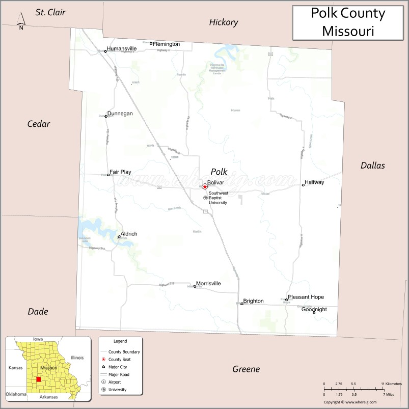
About Polk County Map, Missouri: The map showing the county boundary, county seat, major cities, highways, water bodies and neighbouring counties.
Related Missouri Maps & Info
Polk County, Missouri
Polk County is a county located in the U.S. state of Missouri. It's county seat is Bolivar. As per 2020 census, the population of Polk County is 32043 people and population density is square miles. According to the United States Census Bureau, the county has a total area of 637 sq mi (1,650 km2). Polk County was established on 1835.
Polk County Facts
| Continent | North America |
| Country | United States |
| State | Missouri |
| County Seat | Bolivar |
| Largest City/Town | Bolivar |
| Established | 1835 |
| Total Area | 642 sq mi (1,663 sq km) |
| Land Area | 636 sq mi (1,647 sq km) |
| Water Area | 6 sq mi (16 sq km) |
| Population | 31,137 (Census 2020) |
| Population Density | 49.0 people per sq mi |
| Time Zone | Central Time Zone (CST/CDT) |
| Major Highways | U.S. Route 13, Missouri Route 32, Missouri Route 83, Missouri Route 123 |
| Major Rivers | Pomme de Terre River, Sac River nearby region |
| Neighboring Counties | Hickory County, Dallas County, Greene County, Cedar County, St. Clair County |
| Famous For | Southwest Baptist University, agriculture, outdoor recreation, and Ozark prairie landscapes |
| Top Attractions | Southwest Baptist University, Pomme de Terre Lake nearby region, Dunnegan Memorial Park, and historic downtown Bolivar |
| Official Website | Official Website |
About Polk County
Polk County is located in southwestern Missouri between Springfield and the Ozark Highlands and was established in 1835. The county seat and largest city is Bolivar. The county is known for education, agriculture, rolling countryside, and outdoor recreation opportunities near lakes and rivers.
Cities and Towns in Polk County, Missouri
| City/Town | Population (Census 2020) | Latitude & Longitude |
|---|---|---|
| Bolivar (county seat) | 10,679 | 37.6145°N, 93.4105°W |
| Pleasant Hope | 614 | 37.4634°N, 93.2724°W |
| Fair Play | 418 | 37.6317°N, 93.5941°W |
| Humansville | 1,048 | 37.7948°N, 93.5760°W |
| Morrisville | 360 | 37.4870°N, 93.4316°W |
| Halfway | 173 | 37.6189°N, 93.2861°W |
What are the Golf Courses in Polk County
| Golf Course | Location | Latitude & Longitude |
|---|---|---|
| Silo Ridge Golf and Country Club | Bolivar | 37.6268°N, 93.4244°W |
| Bolivar Municipal Golf Course | Bolivar | 37.6071°N, 93.3997°W |
| Pomme de Terre Recreation Golf Area | Fair Play nearby region | 37.6402°N, 93.6065°W |
Major Roads and Highways in Polk County
Major highways connect Polk County with Springfield, Kansas City, and southwest Missouri communities.
- U.S. Route 13 - major north-south highway through western Missouri
- Missouri Route 32 - important east-west regional transportation route
- Missouri Route 83 - connector route serving rural communities and recreation areas
- Missouri Route 123 - scenic route linking towns and Ozark countryside
What are Neighboring Counties of Polk County
- Hickory County (north)
- Dallas County (east)
- Greene County (south)
- Cedar County (west)
- St. Clair County (northwest)
What Are the Top Attractions in Polk County
The county offers educational attractions, outdoor recreation, scenic countryside, and community events.
- Southwest Baptist University - historic campus, athletics, and cultural activities
- Pomme de Terre Lake nearby region - boating, fishing, camping, and lakeside recreation
- Dunnegan Memorial Park - trails, sports facilities, and family recreation
- Historic Downtown Bolivar - local shops, restaurants, and community festivals
- Ozark Prairie Scenic Drives - rolling farmland and countryside photography opportunities
- Fishing and Camping Areas - outdoor recreation along rivers and lakes
- Community Festivals and County Fair Events - seasonal celebrations and agricultural traditions
- Wildlife Observation Areas - birdwatching and nature exploration
- Historic Rural Churches and Barns - preserved agricultural heritage landmarks
- Outdoor Parks and Picnic Areas - family-friendly recreation and relaxation spaces
What Is the Distance from Polk County to Nearby Cities
The following distances are measured by road (driving).
- Bolivar to Springfield (Greene County), Missouri - 31 mi (50 km)
- Bolivar to Kansas City (Jackson County), Missouri - 151 mi (243 km)
- Bolivar to Branson (Taney County), Missouri - 84 mi (135 km)
- Bolivar to Joplin (Jasper County), Missouri - 90 mi (145 km)
- Bolivar to Pleasant Hope (Polk County), Missouri - 11 mi (18 km)
- Bolivar to Humansville (Polk County), Missouri - 18 mi (29 km)
- Bolivar to Columbia (Boone County), Missouri - 148 mi (238 km)
- Bolivar to St. Louis (St. Louis City), Missouri - 248 mi (399 km)
- Bolivar to Little Rock (Pulaski County), Arkansas - 233 mi (375 km)
- Bolivar to Tulsa (Tulsa County), Oklahoma - 178 mi (286 km)
- Bolivar to Dallas (Dallas County), Texas - 431 mi (694 km)
- Bolivar to Chicago (Cook County), Illinois - 543 mi (874 km)
- Bolivar to Denver (Denver County), Colorado - 685 mi (1,102 km)
FAQs about Polk County
Polk County is located in southwestern Missouri between Springfield and the Ozark Highlands.
Polk County had a population of 31,137 according to the 2020 United States Census.
Polk County is known for Southwest Baptist University, agriculture, and outdoor recreation.
The county is served by U.S. Route 13, Missouri Route 32, Missouri Route 83, and Missouri Route 123.
Yes, Polk County includes golf facilities such as Silo Ridge Golf and Country Club and Bolivar Municipal Golf Course.
References
- QuickFacts - U.S. Census Bureau
- United States Census Bureau
- United States Geological Survey (USGS)
- National Geodetic Survey
- Official Website
- Adair County Map
- Andrew County Map
- Atchison County Map
- Audrain County Map
- Barry County Map
- Barton County Map
- Bates County Map
- Benton County Map
- Bollinger County Map
- Boone County Map
- Buchanan County Map
- Butler County Map
- Caldwell County Map
- Callaway County Map
- Camden County Map
- Cape Girardeau County Map
- Carroll County Map
- Carter County Map
- Cass County Map
- Cedar County Map
- Chariton County Map
- Christian County Map
- Clark County Map
- Clay County Map
- Clinton County Map
- Cole County Map
- Cooper County Map
- Crawford County Map
- Dade County Map
- Dallas County Map
- Daviess County Map
- DeKalb County Map
- Dent County Map
- Douglas County Map
- Dunklin County Map
- Franklin County Map
- Gasconade County Map
- Gentry County Map
- Greene County Map
- Grundy County Map
- Harrison County Map
- Henry County Map
- Hickory County Map
- Holt County Map
- Howard County Map
- Howell County Map
- Iron County Map
- Jackson County Map
- Jasper County Map
- Jefferson County Map
- Johnson County Map
- Knox County Map
- Laclede County Map
- Lafayette County Map
- Lawrence County Map
- Lewis County Map
- Lincoln County Map
- Linn County Map
- Livingston County Map
- McDonald County Map
- Macon County Map
- Madison County Map
- Maries County Map
- Marion County Map
- Mercer County Map
- Miller County Map
- Mississippi County Map
- Moniteau County Map
- Monroe County Map
- Montgomery County Map
- Morgan County Map
- New Madrid County Map
- Newton County Map
- Nodaway County Map
- Oregon County Map
- Osage County Map
- Ozark County Map
- Pemiscot County Map
- Perry County Map
- Pettis County Map
- Phelps County Map
- Pike County Map
- Platte County Map
- Polk County Map
- Pulaski County Map
- Putnam County Map
- Ralls County Map
- Randolph County Map
- Ray County Map
- Reynolds County Map
- Ripley County Map
- St Charles County Map
- St Clair County Map
- Ste Genevieve County Map
- St Francois County Map
- St Louis County Map
- Saline County Map
- Schuyler County Map
- Scotland County Map
- Scott County Map
- Shannon County Map
- Shelby County Map
- Stoddard County Map
- Stone County Map
- Sullivan County Map
- Taney County Map
- Texas County Map
- Vernon County Map
- Warren County Map
- Washington County Map
- Wayne County Map
- Webster County Map
- Worth County Map
- Wright County Map
- St Louis County Map
- Alabama Counties
- Alaska boroughs
- Arizona Counties
- Arkansas Counties
- California County Map
- Colorado Counties
- Connecticut Counties
- Delaware Counties
- Florida County Map
- Georgia County Map
- Hawaii Counties
- Idaho Counties
- Illinois Counties
- Indiana Counties
- Iowa Counties
- Kansas Counties
- Kentucky Counties
- Louisiana Counties
- Maine Counties
- Maryland Counties
- Massachusetts Counties
- Michigan County Map
- Minnesota Counties
- Mississippi Counties
- Missouri Counties
- Montana Counties
- Nebraska Counties
- Nevada Counties
- New York Counties
- New Hampshire Counties
- New Jersey Counties
- New Mexico Counties
- North Carolina Counties
- North Dakota Counties
- Ohio County Map
- Oklahoma Counties
- Oregon Counties
- Pennsylvania Counties
- Rhode Island Counties
- South Carolina Counties
- South Dakota Counties
- Map of Tennessee
- Texas County Map
- Utah Counties
- Vermont Counties
- Virginia Counties
- Washington Counties
- West Virginia Counties
- Wisconsin Counties
- Wyoming Counties