Map of Dallas County - Dallas County is a county located in the U.S. state of Missouri. Dallas County Map showing cities, highways, important places and water bodies. Get Where is Dallas County located in the map, major cities in Dallas county, population, areas, and places of interest.
Map of Dallas County, Missouri
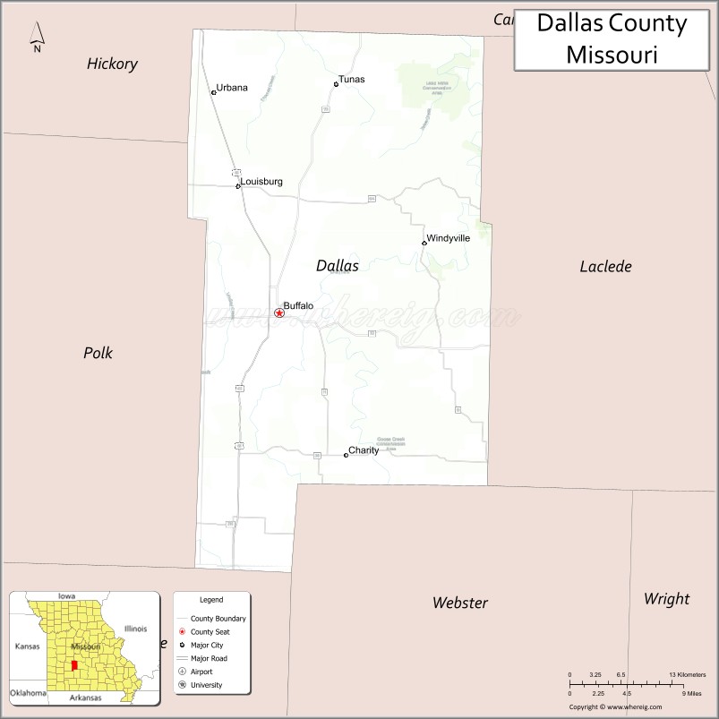
About Dallas County Map, Missouri: The map showing the county boundary, county seat, major cities, highways, water bodies and neighbouring counties.
Related Missouri Maps & Info
Dallas County, Missouri
Dallas County is a county located in the U.S. state of Missouri. It's county seat is Buffalo. As per 2020 census, the population of Dallas County is 17341 people and population density is square miles. According to the United States Census Bureau, the county has a total area of 542 sq mi (1,404 km2). Dallas County was established on 1841.
Dallas County Facts
| Continent | North America |
| Country | United States |
| State | Missouri |
| County Seat | Buffalo |
| Largest City/Town | Buffalo |
| Established | 1844 |
| Total Area | 543 sq mi (1,406 sq km) |
| Land Area | 541 sq mi (1,401 sq km) |
| Water Area | 2 sq mi (5 sq km) |
| Population | 17,071 (Census 2020) |
| Population Density | 31.6 people per sq mi |
| Time Zone | Central Time Zone (CST/CDT) |
| Major Highways | U.S. Route 65, Missouri Route 32, Missouri Route 73 |
| Major Rivers | Niangua River, Little Niangua River |
| Neighboring Counties | Laclede County, Polk County, Greene County, Hickory County, Webster County |
| Famous For | Ozark countryside, fishing streams, outdoor recreation, and rural Missouri communities |
| Top Attractions | Bennett Spring State Park nearby region, Niangua River recreation, Buffalo historic square, and Lead Mine Conservation Area |
| Official Website | Official Website |
About Dallas County
Dallas County is located in southwestern Missouri in the Ozarks region and was established in 1844. The county seat and largest city is Buffalo. The county is known for rolling hills, streams, forests, outdoor recreation, and its location near popular Ozark fishing and camping destinations.
Cities and Towns in Dallas County, Missouri
| City/Town | Population (Census 2020) | Latitude & Longitude |
|---|---|---|
| Buffalo (county seat) | 3,290 | 37.6431°N, 93.0921°W |
| Urbana | 417 | 37.8464°N, 93.1630°W |
| Louisburg nearby area | 198 | 37.6745°N, 92.9698°W |
| Tunas nearby area | 82 | 37.8487°N, 92.9764°W |
| Long Lane nearby area | 64 | 37.6030°N, 92.9105°W |
| Charity nearby area | 51 | 37.7027°N, 93.0144°W |
What are the Golf Courses in Dallas County
| Golf Course | Location | Latitude & Longitude |
|---|---|---|
| Buffalo Bowl Golf Course | Buffalo | 37.6508°N, 93.0996°W |
| Niangua Hills Golf Recreation Area | Urbana nearby region | 37.8382°N, 93.1707°W |
Major Roads and Highways in Dallas County
Major highways connect the county with Springfield, central Missouri, and Ozark recreation regions.
- U.S. Route 65 - major north-south highway through central Missouri
- Missouri Route 32 - east-west route linking rural communities and recreation areas
- Missouri Route 73 - scenic highway serving agricultural and forested regions
What are Neighboring Counties of Dallas County
- Hickory County (north)
- Laclede County (east)
- Webster County (south)
- Greene County (southwest)
- Polk County (west)
What Are the Top Attractions in Dallas County
The county offers a mix of rivers, forests, parks, and outdoor recreation destinations.
- Bennett Spring State Park nearby region - trout fishing, hiking, camping, and spring-fed streams
- Niangua River Recreation Areas - canoeing, kayaking, and fishing opportunities
- Buffalo Historic Square - courthouse district, local shops, and dining
- Lead Mine Conservation Area - wildlife viewing, hiking, and nature exploration
- Ozark Scenic Drives - rolling hills, forests, and rural countryside landscapes
- Dallas County Museum - exhibits on pioneer history and local heritage
- Fishing and Camping Areas - outdoor recreation throughout the county
- Community Parks and Fairgrounds - seasonal festivals, rodeos, and family events
- Mark Twain National Forest nearby region - hiking, camping, and wildlife observation
- Niangua Wildlife Habitats - birdwatching and native Ozark species observation
What Is the Distance from Dallas County to Nearby Cities
The following distances are measured by road (driving).
- Buffalo to Springfield (Greene County), Missouri - 33 mi (53 km)
- Buffalo to Lebanon (Laclede County), Missouri - 34 mi (55 km)
- Buffalo to Bolivar (Polk County), Missouri - 29 mi (47 km)
- Buffalo to Lake Ozark (Miller County), Missouri - 86 mi (138 km)
- Buffalo to Urbana (Dallas County), Missouri - 15 mi (24 km)
- Buffalo to Louisburg nearby area - 12 mi (19 km)
- Buffalo to Branson (Taney County), Missouri - 86 mi (138 km)
- Buffalo to Kansas City (Jackson County), Missouri - 176 mi (283 km)
- Buffalo to Saint Louis (St. Louis City), Missouri - 209 mi (336 km)
- Buffalo to Tulsa (Tulsa County), Oklahoma - 220 mi (354 km)
- Buffalo to Little Rock (Pulaski County), Arkansas - 236 mi (380 km)
- Buffalo to Chicago (Cook County), Illinois - 524 mi (843 km)
- Buffalo to Denver (Denver County), Colorado - 685 mi (1,102 km)
FAQs about Dallas County
Dallas County is located in southwestern Missouri in the Ozarks region.
Dallas County had a population of 17,071 according to the 2020 United States Census.
Dallas County is known for Ozark countryside, fishing streams, outdoor recreation, and rural communities.
The county is served by U.S. Route 65, Missouri Route 32, and Missouri Route 73.
Yes, Dallas County includes golf facilities such as Buffalo Bowl Golf Course and Niangua Hills Golf Recreation Area.
References
- QuickFacts - U.S. Census Bureau
- United States Census Bureau
- United States Geological Survey (USGS)
- National Geodetic Survey
- Official Website
- Adair County Map
- Andrew County Map
- Atchison County Map
- Audrain County Map
- Barry County Map
- Barton County Map
- Bates County Map
- Benton County Map
- Bollinger County Map
- Boone County Map
- Buchanan County Map
- Butler County Map
- Caldwell County Map
- Callaway County Map
- Camden County Map
- Cape Girardeau County Map
- Carroll County Map
- Carter County Map
- Cass County Map
- Cedar County Map
- Chariton County Map
- Christian County Map
- Clark County Map
- Clay County Map
- Clinton County Map
- Cole County Map
- Cooper County Map
- Crawford County Map
- Dade County Map
- Dallas County Map
- Daviess County Map
- DeKalb County Map
- Dent County Map
- Douglas County Map
- Dunklin County Map
- Franklin County Map
- Gasconade County Map
- Gentry County Map
- Greene County Map
- Grundy County Map
- Harrison County Map
- Henry County Map
- Hickory County Map
- Holt County Map
- Howard County Map
- Howell County Map
- Iron County Map
- Jackson County Map
- Jasper County Map
- Jefferson County Map
- Johnson County Map
- Knox County Map
- Laclede County Map
- Lafayette County Map
- Lawrence County Map
- Lewis County Map
- Lincoln County Map
- Linn County Map
- Livingston County Map
- McDonald County Map
- Macon County Map
- Madison County Map
- Maries County Map
- Marion County Map
- Mercer County Map
- Miller County Map
- Mississippi County Map
- Moniteau County Map
- Monroe County Map
- Montgomery County Map
- Morgan County Map
- New Madrid County Map
- Newton County Map
- Nodaway County Map
- Oregon County Map
- Osage County Map
- Ozark County Map
- Pemiscot County Map
- Perry County Map
- Pettis County Map
- Phelps County Map
- Pike County Map
- Platte County Map
- Polk County Map
- Pulaski County Map
- Putnam County Map
- Ralls County Map
- Randolph County Map
- Ray County Map
- Reynolds County Map
- Ripley County Map
- St Charles County Map
- St Clair County Map
- Ste Genevieve County Map
- St Francois County Map
- St Louis County Map
- Saline County Map
- Schuyler County Map
- Scotland County Map
- Scott County Map
- Shannon County Map
- Shelby County Map
- Stoddard County Map
- Stone County Map
- Sullivan County Map
- Taney County Map
- Texas County Map
- Vernon County Map
- Warren County Map
- Washington County Map
- Wayne County Map
- Webster County Map
- Worth County Map
- Wright County Map
- St Louis County Map
- Alabama Counties
- Alaska boroughs
- Arizona Counties
- Arkansas Counties
- California County Map
- Colorado Counties
- Connecticut Counties
- Delaware Counties
- Florida County Map
- Georgia County Map
- Hawaii Counties
- Idaho Counties
- Illinois Counties
- Indiana Counties
- Iowa Counties
- Kansas Counties
- Kentucky Counties
- Louisiana Counties
- Maine Counties
- Maryland Counties
- Massachusetts Counties
- Michigan County Map
- Minnesota Counties
- Mississippi Counties
- Missouri Counties
- Montana Counties
- Nebraska Counties
- Nevada Counties
- New York Counties
- New Hampshire Counties
- New Jersey Counties
- New Mexico Counties
- North Carolina Counties
- North Dakota Counties
- Ohio County Map
- Oklahoma Counties
- Oregon Counties
- Pennsylvania Counties
- Rhode Island Counties
- South Carolina Counties
- South Dakota Counties
- Map of Tennessee
- Texas County Map
- Utah Counties
- Vermont Counties
- Virginia Counties
- Washington Counties
- West Virginia Counties
- Wisconsin Counties
- Wyoming Counties