Map of Carter County - Carter County is a county located in the U.S. state of Missouri. Carter County Map showing cities, highways, important places and water bodies. Get Where is Carter County located in the map, major cities in Carter county, population, areas, and places of interest.
Map of Carter County, Missouri
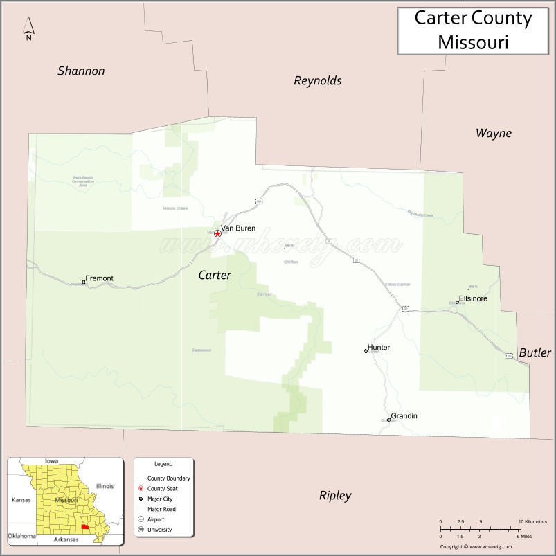
About Carter County Map, Missouri: The map showing the county boundary, county seat, major cities, highways, water bodies and neighbouring counties.
Related Missouri Maps & Info
Carter County, Missouri
Carter County is a county located in the U.S. state of Missouri. It's county seat is Van Buren. As per 2020 census, the population of Carter County is 5320 people and population density is square miles. According to the United States Census Bureau, the county has a total area of 508 sq mi (1,316 km2). Carter County was established on 1859.
Carter County Facts
| Continent | North America |
| Country | United States |
| State | Missouri |
| County Seat | Van Buren |
| Largest City/Town | Van Buren |
| Established | 1859 |
| Total Area | 507 sq mi (1,313 sq km) |
| Land Area | 507 sq mi (1,313 sq km) |
| Water Area | 0.2 sq mi (0.5 sq km) |
| Population | 5,202 (Census 2020) |
| Population Density | 10.3 people per sq mi |
| Time Zone | Central Time Zone (CST/CDT) |
| Major Highways | U.S. Route 60, Missouri Route 21, Missouri Route 103 |
| Major Rivers | Current River, Black River nearby region |
| Neighboring Counties | Shannon County, Reynolds County, Ripley County, Wayne County, Butler County |
| Famous For | Ozark wilderness, Current River recreation, floating, fishing, and scenic forests |
| Top Attractions | Ozark National Scenic Riverways, Current River, Big Spring nearby region, and Peck Ranch Conservation Area |
| Official Website | Official Website |
About Carter County
Carter County is located in southeastern Missouri in the Ozark Highlands region and was established in 1859. The county seat and largest city is Van Buren. The county is known for its forests, rivers, wilderness landscapes, outdoor recreation, and scenic stretches of the Current River within the Ozark National Scenic Riverways.
Cities and Towns in Carter County, Missouri
| City/Town | Population (Census 2020) | Latitude & Longitude |
|---|---|---|
| Van Buren (county seat) | 747 | 36.9898°N, 91.0123°W |
| Ellsinore | 463 | 36.9328°N, 90.7462°W |
| Grandin | 231 | 36.8287°N, 90.8154°W |
| Hunter nearby area | 92 | 36.8951°N, 90.9364°W |
| Fremont nearby area | 129 | 36.9515°N, 91.1593°W |
| Eastwood Community | 54 | 37.0274°N, 90.8852°W |
What are the Golf Courses in Carter County
| Golf Course | Location | Latitude & Longitude |
|---|---|---|
| Current River Golf Recreation Area | Van Buren | 36.9941°N, 91.0187°W |
| Ozark Hills Golf Area | Ellsinore | 36.9394°N, 90.7520°W |
Major Roads and Highways in Carter County
Major highways connect the county with southeastern Missouri communities and Ozark recreation regions.
- U.S. Route 60 - major east-west transportation corridor across southern Missouri
- Missouri Route 21 - scenic north-south highway through the Ozarks
- Missouri Route 103 - route connecting recreation and river access areas
What are Neighboring Counties of Carter County
- Reynolds County (north)
- Shannon County (west)
- Wayne County (east)
- Butler County (southeast)
- Ripley County (south)
What Are the Top Attractions in Carter County
The county offers a mix of rivers, forests, wilderness areas, and outdoor recreation opportunities.
- Ozark National Scenic Riverways - protected river system with floating, hiking, and camping
- Current River - popular destination for canoeing, kayaking, fishing, and swimming
- Big Spring nearby region - one of the largest natural springs in the United States
- Peck Ranch Conservation Area - wildlife viewing, elk habitat, hiking, and forests
- Mark Twain National Forest nearby areas - scenic drives, camping, and outdoor recreation
- Van Buren Riverfront - river access points, picnic areas, and local recreation
- Ozark Scenic Byways - rolling hills, forests, and panoramic overlooks
- Rocky Falls nearby area - natural waterfall and swimming location
- Fishing and Float Outfitters - guided river trips and outdoor adventure services
- Wildlife Observation Areas - habitats for elk, deer, birds, and Ozark wildlife species
What Is the Distance from Carter County to Nearby Cities
The following distances are measured by road (driving).
- Van Buren to Poplar Bluff (Butler County), Missouri - 44 mi (71 km)
- Van Buren to Cape Girardeau (Cape Girardeau County), Missouri - 114 mi (183 km)
- Van Buren to West Plains (Howell County), Missouri - 73 mi (117 km)
- Van Buren to Eminence (Shannon County), Missouri - 35 mi (56 km)
- Van Buren to Ellsinore (Carter County), Missouri - 18 mi (29 km)
- Van Buren to Grandin (Carter County), Missouri - 24 mi (39 km)
- Van Buren to Springfield (Greene County), Missouri - 175 mi (282 km)
- Van Buren to Saint Louis (St. Louis City), Missouri - 190 mi (306 km)
- Van Buren to Memphis (Shelby County), Tennessee - 204 mi (328 km)
- Van Buren to Little Rock (Pulaski County), Arkansas - 197 mi (317 km)
- Van Buren to Nashville (Davidson County), Tennessee - 323 mi (520 km)
- Van Buren to Kansas City (Jackson County), Missouri - 333 mi (536 km)
- Van Buren to Denver (Denver County), Colorado - 828 mi (1,332 km)
FAQs about Carter County
Carter County is located in southeastern Missouri in the Ozark Highlands region.
Carter County had a population of 5,202 according to the 2020 United States Census.
Carter County is known for Ozark wilderness, Current River recreation, floating, fishing, and scenic forests.
The county is served by U.S. Route 60, Missouri Route 21, and Missouri Route 103.
Yes, Carter County includes golf recreation facilities such as Current River Golf Recreation Area and Ozark Hills Golf Area.
References
- QuickFacts - U.S. Census Bureau
- United States Census Bureau
- United States Geological Survey (USGS)
- National Geodetic Survey
- Official Website
- Adair County Map
- Andrew County Map
- Atchison County Map
- Audrain County Map
- Barry County Map
- Barton County Map
- Bates County Map
- Benton County Map
- Bollinger County Map
- Boone County Map
- Buchanan County Map
- Butler County Map
- Caldwell County Map
- Callaway County Map
- Camden County Map
- Cape Girardeau County Map
- Carroll County Map
- Carter County Map
- Cass County Map
- Cedar County Map
- Chariton County Map
- Christian County Map
- Clark County Map
- Clay County Map
- Clinton County Map
- Cole County Map
- Cooper County Map
- Crawford County Map
- Dade County Map
- Dallas County Map
- Daviess County Map
- DeKalb County Map
- Dent County Map
- Douglas County Map
- Dunklin County Map
- Franklin County Map
- Gasconade County Map
- Gentry County Map
- Greene County Map
- Grundy County Map
- Harrison County Map
- Henry County Map
- Hickory County Map
- Holt County Map
- Howard County Map
- Howell County Map
- Iron County Map
- Jackson County Map
- Jasper County Map
- Jefferson County Map
- Johnson County Map
- Knox County Map
- Laclede County Map
- Lafayette County Map
- Lawrence County Map
- Lewis County Map
- Lincoln County Map
- Linn County Map
- Livingston County Map
- McDonald County Map
- Macon County Map
- Madison County Map
- Maries County Map
- Marion County Map
- Mercer County Map
- Miller County Map
- Mississippi County Map
- Moniteau County Map
- Monroe County Map
- Montgomery County Map
- Morgan County Map
- New Madrid County Map
- Newton County Map
- Nodaway County Map
- Oregon County Map
- Osage County Map
- Ozark County Map
- Pemiscot County Map
- Perry County Map
- Pettis County Map
- Phelps County Map
- Pike County Map
- Platte County Map
- Polk County Map
- Pulaski County Map
- Putnam County Map
- Ralls County Map
- Randolph County Map
- Ray County Map
- Reynolds County Map
- Ripley County Map
- St Charles County Map
- St Clair County Map
- Ste Genevieve County Map
- St Francois County Map
- St Louis County Map
- Saline County Map
- Schuyler County Map
- Scotland County Map
- Scott County Map
- Shannon County Map
- Shelby County Map
- Stoddard County Map
- Stone County Map
- Sullivan County Map
- Taney County Map
- Texas County Map
- Vernon County Map
- Warren County Map
- Washington County Map
- Wayne County Map
- Webster County Map
- Worth County Map
- Wright County Map
- St Louis County Map
- Alabama Counties
- Alaska boroughs
- Arizona Counties
- Arkansas Counties
- California County Map
- Colorado Counties
- Connecticut Counties
- Delaware Counties
- Florida County Map
- Georgia County Map
- Hawaii Counties
- Idaho Counties
- Illinois Counties
- Indiana Counties
- Iowa Counties
- Kansas Counties
- Kentucky Counties
- Louisiana Counties
- Maine Counties
- Maryland Counties
- Massachusetts Counties
- Michigan County Map
- Minnesota Counties
- Mississippi Counties
- Missouri Counties
- Montana Counties
- Nebraska Counties
- Nevada Counties
- New York Counties
- New Hampshire Counties
- New Jersey Counties
- New Mexico Counties
- North Carolina Counties
- North Dakota Counties
- Ohio County Map
- Oklahoma Counties
- Oregon Counties
- Pennsylvania Counties
- Rhode Island Counties
- South Carolina Counties
- South Dakota Counties
- Map of Tennessee
- Texas County Map
- Utah Counties
- Vermont Counties
- Virginia Counties
- Washington Counties
- West Virginia Counties
- Wisconsin Counties
- Wyoming Counties