Map of New Madrid County - New Madrid County is a county located in the U.S. state of Missouri. New Madrid County Map showing cities, highways, important places and water bodies. Get Where is New Madrid County located in the map, major cities in New Madrid county, population, areas, and places of interest.
Map of New Madrid County, Missouri
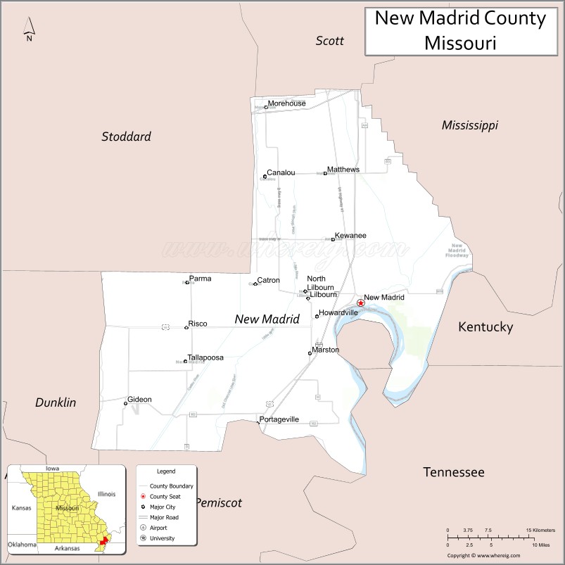
About New Madrid County Map, Missouri: The map showing the county boundary, county seat, major cities, highways, water bodies and neighbouring counties.
Related Missouri Maps & Info
New Madrid County, Missouri
New Madrid County is a county located in the U.S. state of Missouri. It's county seat is New Madrid. As per 2020 census, the population of New Madrid County is 16035 people and population density is square miles. According to the United States Census Bureau, the county has a total area of 678 sq mi (1,756 km2). New Madrid County was established on 1812.
New Madrid County Facts
| Continent | North America |
| Country | United States |
| State | Missouri |
| County Seat | New Madrid |
| Largest City/Town | Portageville |
| Established | 1812 |
| Total Area | 697 sq mi (1,805 sq km) |
| Land Area | 675 sq mi (1,748 sq km) |
| Water Area | 22 sq mi (57 sq km) |
| Population | 16,434 (Census 2020) |
| Population Density | 24.3 people per sq mi |
| Time Zone | Central Time Zone (CST/CDT) |
| Major Highways | Interstate 55, U.S. Route 61, Missouri Route 162, Missouri Route 25 |
| Major Rivers | Mississippi River, St. Johns Bayou |
| Neighboring Counties | Mississippi County, Scott County, Pemiscot County, Dunklin County, Lake County (Tennessee) |
| Famous For | New Madrid earthquakes, Mississippi River history, agriculture, and Bootheel landscapes |
| Top Attractions | New Madrid Historical Museum, Mississippi River overlooks, Big Oak Tree State Park nearby region, and earthquake heritage sites |
| Official Website | Official Website |
About New Madrid County
New Madrid County is located in the southeastern Missouri Bootheel along the Mississippi River and was established in 1812. The county seat is New Madrid, while Portageville is the largest city. The county is internationally known for the historic New Madrid earthquakes of 1811–1812, fertile agricultural land, and Mississippi River heritage.
Cities and Towns in New Madrid County, Missouri
| City/Town | Population (Census 2020) | Latitude & Longitude |
|---|---|---|
| Portageville | 2,228 | 36.4256°N, 89.6998°W |
| New Madrid (county seat) | 2,841 | 36.5864°N, 89.5279°W |
| Sikeston nearby region | 16,291 | 36.8767°N, 89.5879°W |
| Howardville | 271 | 36.5684°N, 89.5984°W |
| Matthews | 547 | 36.7595°N, 89.5865°W |
| Lilbourn | 1,023 | 36.5923°N, 89.6154°W |
What are the Golf Courses in New Madrid County
| Golf Course | Location | Latitude & Longitude |
|---|---|---|
| New Madrid Country Club | New Madrid | 36.5981°N, 89.5398°W |
| Portageville Recreation Golf Area | Portageville | 36.4339°N, 89.7081°W |
| Bootheel Regional Golf Course nearby region | Sikeston area | 36.8851°N, 89.6015°W |
Major Roads and Highways in New Madrid County
Major highways connect New Madrid County with the Mississippi River corridor, Tennessee, and southeastern Missouri communities.
- Interstate 55 - major north-south interstate through the Mississippi Valley
- U.S. Route 61 - historic highway paralleling the Mississippi River
- Missouri Route 162 - regional route serving Bootheel communities
- Missouri Route 25 - connector highway through southeastern Missouri farmland
What are Neighboring Counties of New Madrid County
- Scott County (north)
- Mississippi County (east)
- Pemiscot County (south)
- Dunklin County (southwest)
- Lake County, Tennessee (southeast)
What Are the Top Attractions in New Madrid County
The county offers historic earthquake sites, river scenery, wetlands, and outdoor recreation attractions.
- New Madrid Historical Museum - exhibits on the famous 1811–1812 earthquakes and local history
- Mississippi River Overlooks - scenic river views and photography locations
- Big Oak Tree State Park nearby region - wetlands, birdwatching, and hiking
- New Madrid Earthquake Heritage Sites - historical landmarks and educational displays
- Bootheel Agricultural Landscapes - fertile farmland and Delta scenery
- Fishing and Boating Recreation Areas - outdoor activities along rivers and lakes
- Community Festivals and Heritage Events - local traditions and cultural celebrations
- Bird Migration Viewing Areas - wildlife observation and seasonal habitats
- Historic Downtown New Madrid - local shops, dining, and preserved architecture
- Nature Trails and Conservation Areas - outdoor exploration and environmental education
What Is the Distance from New Madrid County to Nearby Cities
The following distances are measured by road (driving).
- New Madrid to Sikeston (Scott County), Missouri - 34 mi (55 km)
- New Madrid to Cape Girardeau (Cape Girardeau County), Missouri - 73 mi (117 km)
- New Madrid to Memphis (Shelby County), Tennessee - 148 mi (238 km)
- New Madrid to Paducah (McCracken County), Kentucky - 79 mi (127 km)
- New Madrid to Portageville (New Madrid County), Missouri - 19 mi (31 km)
- New Madrid to Lilbourn (New Madrid County), Missouri - 11 mi (18 km)
- New Madrid to St. Louis (St. Louis City), Missouri - 196 mi (315 km)
- New Madrid to Nashville (Davidson County), Tennessee - 219 mi (352 km)
- New Madrid to Little Rock (Pulaski County), Arkansas - 188 mi (303 km)
- New Madrid to Chicago (Cook County), Illinois - 405 mi (652 km)
- New Madrid to Kansas City (Jackson County), Missouri - 395 mi (636 km)
- New Madrid to Dallas (Dallas County), Texas - 486 mi (782 km)
- New Madrid to Denver (Denver County), Colorado - 845 mi (1,360 km)
FAQs about New Madrid County
New Madrid County is located in the southeastern Missouri Bootheel along the Mississippi River.
New Madrid County had a population of 16,434 according to the 2020 United States Census.
New Madrid County is known for the historic New Madrid earthquakes, Mississippi River history, and agriculture.
The county is served by Interstate 55, U.S. Route 61, Missouri Route 162, and Missouri Route 25.
Yes, New Madrid County includes golf facilities such as New Madrid Country Club and recreation golf areas near Portageville.
References
- QuickFacts - U.S. Census Bureau
- United States Census Bureau
- United States Geological Survey (USGS)
- National Geodetic Survey
- Official Website
- Adair County Map
- Andrew County Map
- Atchison County Map
- Audrain County Map
- Barry County Map
- Barton County Map
- Bates County Map
- Benton County Map
- Bollinger County Map
- Boone County Map
- Buchanan County Map
- Butler County Map
- Caldwell County Map
- Callaway County Map
- Camden County Map
- Cape Girardeau County Map
- Carroll County Map
- Carter County Map
- Cass County Map
- Cedar County Map
- Chariton County Map
- Christian County Map
- Clark County Map
- Clay County Map
- Clinton County Map
- Cole County Map
- Cooper County Map
- Crawford County Map
- Dade County Map
- Dallas County Map
- Daviess County Map
- DeKalb County Map
- Dent County Map
- Douglas County Map
- Dunklin County Map
- Franklin County Map
- Gasconade County Map
- Gentry County Map
- Greene County Map
- Grundy County Map
- Harrison County Map
- Henry County Map
- Hickory County Map
- Holt County Map
- Howard County Map
- Howell County Map
- Iron County Map
- Jackson County Map
- Jasper County Map
- Jefferson County Map
- Johnson County Map
- Knox County Map
- Laclede County Map
- Lafayette County Map
- Lawrence County Map
- Lewis County Map
- Lincoln County Map
- Linn County Map
- Livingston County Map
- McDonald County Map
- Macon County Map
- Madison County Map
- Maries County Map
- Marion County Map
- Mercer County Map
- Miller County Map
- Mississippi County Map
- Moniteau County Map
- Monroe County Map
- Montgomery County Map
- Morgan County Map
- New Madrid County Map
- Newton County Map
- Nodaway County Map
- Oregon County Map
- Osage County Map
- Ozark County Map
- Pemiscot County Map
- Perry County Map
- Pettis County Map
- Phelps County Map
- Pike County Map
- Platte County Map
- Polk County Map
- Pulaski County Map
- Putnam County Map
- Ralls County Map
- Randolph County Map
- Ray County Map
- Reynolds County Map
- Ripley County Map
- St Charles County Map
- St Clair County Map
- Ste Genevieve County Map
- St Francois County Map
- St Louis County Map
- Saline County Map
- Schuyler County Map
- Scotland County Map
- Scott County Map
- Shannon County Map
- Shelby County Map
- Stoddard County Map
- Stone County Map
- Sullivan County Map
- Taney County Map
- Texas County Map
- Vernon County Map
- Warren County Map
- Washington County Map
- Wayne County Map
- Webster County Map
- Worth County Map
- Wright County Map
- St Louis County Map
- Alabama Counties
- Alaska boroughs
- Arizona Counties
- Arkansas Counties
- California County Map
- Colorado Counties
- Connecticut Counties
- Delaware Counties
- Florida County Map
- Georgia County Map
- Hawaii Counties
- Idaho Counties
- Illinois Counties
- Indiana Counties
- Iowa Counties
- Kansas Counties
- Kentucky Counties
- Louisiana Counties
- Maine Counties
- Maryland Counties
- Massachusetts Counties
- Michigan County Map
- Minnesota Counties
- Mississippi Counties
- Missouri Counties
- Montana Counties
- Nebraska Counties
- Nevada Counties
- New York Counties
- New Hampshire Counties
- New Jersey Counties
- New Mexico Counties
- North Carolina Counties
- North Dakota Counties
- Ohio County Map
- Oklahoma Counties
- Oregon Counties
- Pennsylvania Counties
- Rhode Island Counties
- South Carolina Counties
- South Dakota Counties
- Map of Tennessee
- Texas County Map
- Utah Counties
- Vermont Counties
- Virginia Counties
- Washington Counties
- West Virginia Counties
- Wisconsin Counties
- Wyoming Counties