Map of Saint Francois County - Saint Francois County is a county located in the U.S. state of Missouri. Saint Francois County Map showing cities, highways, important places and water bodies. Get Where is Saint Francois County located in the map, major cities in Saint Francois county, population, areas, and places of interest.
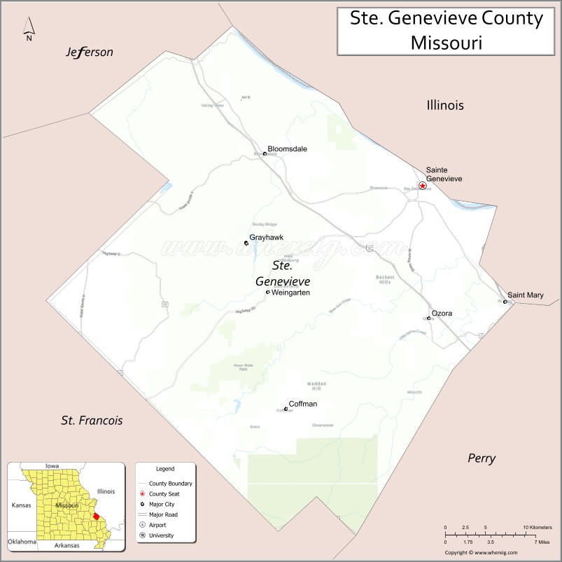
Map of Ste Genevieve County, Missouri
About Saint Francois County Map, Missouri: The map showing the county boundary, county seat, major cities, highways, water bodies and neighbouring counties.
Related Missouri Maps & Info
Ste Genevieve County, Missouri
Scott County is a county located in the U.S. state of Missouri. It`s county seat is Benton. As per 2020 census, the population of Scott County was 37840 and population density of Scott was square miles. According to the United States Census Bureau, the county has a total area of 421 sq mi (1,090 km2). Scott County was established on 1822.
Ste. Genevieve County Facts
| Continent | North America |
| Country | United States |
| State | Missouri |
| County Seat | Ste. Genevieve |
| Largest City/Town | Ste. Genevieve |
| Established | 1812 |
| Total Area | 507 sq mi (1,313 sq km) |
| Land Area | 499 sq mi (1,292 sq km) |
| Water Area | 8 sq mi (21 sq km) |
| Population | 18,479 (Census 2020) |
| Population Density | 37.0 people per sq mi |
| Time Zone | Central Time Zone (CST/CDT) |
| Major Highways | Interstate 55, U.S. Route 61, Missouri Route 32 |
| Major Rivers | Mississippi River, Saline Creek |
| Neighboring Counties | Perry County, St. Francois County, Jefferson County, Washington County, Randolph County (Illinois) |
| Famous For | French colonial history, historic architecture, wineries, and Mississippi River heritage |
| Top Attractions | Historic Ste. Genevieve, Felix Vallé House State Historic Site, Hawn State Park, and Sainte Genevieve Winery |
| Official Website | Official Website |
About Ste. Genevieve County
Ste. Genevieve County is located in eastern Missouri along the Mississippi River and was established in 1812. The county seat and largest city is Ste. Genevieve. The county is famous for its French colonial heritage, preserved historic architecture, vineyards, and scenic river valley landscapes.
Cities and Towns in Ste. Genevieve County, Missouri
| City/Town | Population (Census 2020) | Latitude & Longitude |
|---|---|---|
| Ste. Genevieve (county seat) | 4,476 | 37.9792°N, 90.0498°W |
| Bloomsdale | 508 | 38.0137°N, 90.2218°W |
| St. Mary | 295 | 37.8798°N, 89.9609°W |
| Ozora | 122 | 37.8892°N, 90.0103°W |
| Coffman nearby area | 182 | 37.7528°N, 89.9798°W |
| Weingarten nearby region | 94 | 37.8967°N, 90.1321°W |
What are the Golf Courses in Ste. Genevieve County
| Golf Course | Location | Latitude & Longitude |
|---|---|---|
| Annbriar Golf Course | Waterloo nearby region | 38.3184°N, 90.1491°W |
| Ste. Genevieve Golf Club | Ste. Genevieve | 37.9894°N, 90.0632°W |
| River Valley Recreation Golf Area | Bloomsdale nearby region | 38.0247°N, 90.2340°W |
Major Roads and Highways in Ste. Genevieve County
Major highways connect Ste. Genevieve County with St. Louis and southeastern Missouri communities.
- Interstate 55 - major north-south interstate corridor through eastern Missouri
- U.S. Route 61 - important transportation route along the Mississippi River valley
- Missouri Route 32 - regional connector serving historic towns and rural areas
What are Neighboring Counties of Ste. Genevieve County
- Jefferson County (north)
- Perry County (south)
- St. Francois County (west)
- Washington County (northwest)
- Randolph County, Illinois (east)
What Are the Top Attractions in Ste. Genevieve County
The county offers historic landmarks, wineries, scenic parks, and rich French colonial heritage.
- Historic Ste. Genevieve - preserved French colonial buildings, museums, and walking tours
- Felix Vallé House State Historic Site - restored 19th-century home and cultural exhibits
- Hawn State Park - hiking trails, sandstone canyons, camping, and nature observation
- Sainte Genevieve Winery - wine tasting, vineyard tours, and scenic countryside views
- Mississippi River Scenic Drives - river valley photography and historic landscapes
- French Colonial Heritage Sites - unique architecture and Missouri frontier history
- Pickle Springs Natural Area - hiking and geological formations
- Community Festivals and French Heritage Events - cultural celebrations and seasonal activities
- Parks and Riverfront Recreation Areas - outdoor family activities and picnics
- Historic Churches and Rural Vineyards - preserved cultural landmarks and scenic countryside
What Is the Distance from Ste. Genevieve County to Nearby Cities
The following distances are measured by road (driving).
- Ste. Genevieve to St. Louis (St. Louis City), Missouri - 61 mi (98 km)
- Ste. Genevieve to Cape Girardeau (Cape Girardeau County), Missouri - 76 mi (122 km)
- Ste. Genevieve to Farmington (St. Francois County), Missouri - 38 mi (61 km)
- Ste. Genevieve to Perryville (Perry County), Missouri - 34 mi (55 km)
- Ste. Genevieve to Bloomsdale (Ste. Genevieve County), Missouri - 17 mi (27 km)
- Ste. Genevieve to St. Mary (Ste. Genevieve County), Missouri - 11 mi (18 km)
- Ste. Genevieve to Springfield (Greene County), Missouri - 250 mi (402 km)
- Ste. Genevieve to Kansas City (Jackson County), Missouri - 285 mi (459 km)
- Ste. Genevieve to Chicago (Cook County), Illinois - 336 mi (541 km)
- Ste. Genevieve to Nashville (Davidson County), Tennessee - 300 mi (483 km)
- Ste. Genevieve to Dallas (Dallas County), Texas - 640 mi (1,030 km)
- Ste. Genevieve to Denver (Denver County), Colorado - 873 mi (1,405 km)
- Ste. Genevieve to Memphis (Shelby County), Tennessee - 272 mi (438 km)
FAQs about Ste. Genevieve County
Ste. Genevieve County is located in eastern Missouri along the Mississippi River.
Ste. Genevieve County had a population of 18,479 according to the 2020 United States Census.
Ste. Genevieve County is known for French colonial history, historic architecture, wineries, and river heritage.
The county is served by Interstate 55, U.S. Route 61, and Missouri Route 32.
Yes, Ste. Genevieve County includes golf facilities such as Ste. Genevieve Golf Club and nearby Annbriar Golf Course.
References
- QuickFacts - U.S. Census Bureau
- United States Census Bureau
- United States Geological Survey (USGS)
- National Geodetic Survey
- Official Website
- Adair County Map
- Andrew County Map
- Atchison County Map
- Audrain County Map
- Barry County Map
- Barton County Map
- Bates County Map
- Benton County Map
- Bollinger County Map
- Boone County Map
- Buchanan County Map
- Butler County Map
- Caldwell County Map
- Callaway County Map
- Camden County Map
- Cape Girardeau County Map
- Carroll County Map
- Carter County Map
- Cass County Map
- Cedar County Map
- Chariton County Map
- Christian County Map
- Clark County Map
- Clay County Map
- Clinton County Map
- Cole County Map
- Cooper County Map
- Crawford County Map
- Dade County Map
- Dallas County Map
- Daviess County Map
- DeKalb County Map
- Dent County Map
- Douglas County Map
- Dunklin County Map
- Franklin County Map
- Gasconade County Map
- Gentry County Map
- Greene County Map
- Grundy County Map
- Harrison County Map
- Henry County Map
- Hickory County Map
- Holt County Map
- Howard County Map
- Howell County Map
- Iron County Map
- Jackson County Map
- Jasper County Map
- Jefferson County Map
- Johnson County Map
- Knox County Map
- Laclede County Map
- Lafayette County Map
- Lawrence County Map
- Lewis County Map
- Lincoln County Map
- Linn County Map
- Livingston County Map
- McDonald County Map
- Macon County Map
- Madison County Map
- Maries County Map
- Marion County Map
- Mercer County Map
- Miller County Map
- Mississippi County Map
- Moniteau County Map
- Monroe County Map
- Montgomery County Map
- Morgan County Map
- New Madrid County Map
- Newton County Map
- Nodaway County Map
- Oregon County Map
- Osage County Map
- Ozark County Map
- Pemiscot County Map
- Perry County Map
- Pettis County Map
- Phelps County Map
- Pike County Map
- Platte County Map
- Polk County Map
- Pulaski County Map
- Putnam County Map
- Ralls County Map
- Randolph County Map
- Ray County Map
- Reynolds County Map
- Ripley County Map
- St Charles County Map
- St Clair County Map
- Ste Genevieve County Map
- St Francois County Map
- St Louis County Map
- Saline County Map
- Schuyler County Map
- Scotland County Map
- Scott County Map
- Shannon County Map
- Shelby County Map
- Stoddard County Map
- Stone County Map
- Sullivan County Map
- Taney County Map
- Texas County Map
- Vernon County Map
- Warren County Map
- Washington County Map
- Wayne County Map
- Webster County Map
- Worth County Map
- Wright County Map
- St Louis County Map
- Alabama Counties
- Alaska boroughs
- Arizona Counties
- Arkansas Counties
- California County Map
- Colorado Counties
- Connecticut Counties
- Delaware Counties
- Florida County Map
- Georgia County Map
- Hawaii Counties
- Idaho Counties
- Illinois Counties
- Indiana Counties
- Iowa Counties
- Kansas Counties
- Kentucky Counties
- Louisiana Counties
- Maine Counties
- Maryland Counties
- Massachusetts Counties
- Michigan County Map
- Minnesota Counties
- Mississippi Counties
- Missouri Counties
- Montana Counties
- Nebraska Counties
- Nevada Counties
- New York Counties
- New Hampshire Counties
- New Jersey Counties
- New Mexico Counties
- North Carolina Counties
- North Dakota Counties
- Ohio County Map
- Oklahoma Counties
- Oregon Counties
- Pennsylvania Counties
- Rhode Island Counties
- South Carolina Counties
- South Dakota Counties
- Map of Tennessee
- Texas County Map
- Utah Counties
- Vermont Counties
- Virginia Counties
- Washington Counties
- West Virginia Counties
- Wisconsin Counties
- Wyoming Counties