Map of Christian County - Christian County is a county located in the U.S. state of Missouri. Christian County Map showing cities, highways, important places and water bodies. Get Where is Christian County located in the map, major cities in Christian county, population, areas, and places of interest.
Map of Christian County, Missouri
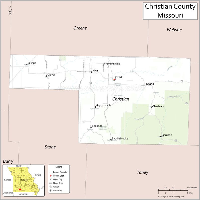
About Christian County Map, Missouri: The map showing the county boundary, county seat, major cities, highways, water bodies and neighbouring counties.
Related Missouri Maps & Info
Christian County, Missouri
Christian County is a county located in the U.S. state of Missouri. It's county seat is Ozark. As per 2020 census, the population of Christian County is 91499 people and population density is square miles. According to the United States Census Bureau, the county has a total area of 563 sq mi (1,458 km2). Christian County was established on 1859.
Christian County Facts
| Continent | North America |
| Country | United States |
| State | Missouri |
| County Seat | Ozark |
| Largest City/Town | Nixa |
| Established | 1859 |
| Total Area | 564 sq mi (1,461 sq km) |
| Land Area | 563 sq mi (1,458 sq km) |
| Water Area | 1 sq mi (3 sq km) |
| Population | 88,842 (Census 2020) |
| Population Density | 157.8 people per sq mi |
| Time Zone | Central Time Zone (CST/CDT) |
| Major Highways | U.S. Route 65, U.S. Route 160, Missouri Route 14 |
| Major Rivers | Finley River, James River |
| Neighboring Counties | Greene County, Stone County, Taney County, Douglas County, Webster County, Lawrence County |
| Famous For | Springfield suburban growth, Ozark scenery, outdoor recreation, and family-friendly communities |
| Top Attractions | Smallin Civil War Cave, Finley River Park, Ozark Mill, and nearby Branson attractions |
| Official Website | Official Website |
About Christian County
Christian County is located in southwestern Missouri in the Ozarks region and was established in 1859. The county seat is Ozark, while Nixa is the largest city. The county is known for rapid suburban growth near Springfield, scenic Ozark landscapes, outdoor recreation, and family-oriented communities.
Cities and Towns in Christian County, Missouri
| City/Town | Population (Census 2020) | Latitude & Longitude |
|---|---|---|
| Nixa | 23,257 | 37.0434°N, 93.2944°W |
| Ozark (county seat) | 21,284 | 37.0209°N, 93.2060°W |
| Clever | 2,119 | 37.0303°N, 93.4733°W |
| Highlandville | 1,012 | 36.9334°N, 93.2824°W |
| Sparta | 1,756 | 36.9912°N, 93.0888°W |
| Billings | 1,035 | 37.0670°N, 93.5532°W |
What are the Golf Courses in Christian County
| Golf Course | Location | Latitude & Longitude |
|---|---|---|
| Rivercut Golf Course nearby region | Ozark | 37.0026°N, 93.2791°W |
| Fremont Hills Country Club | Nixa | 37.0358°N, 93.2521°W |
| Hidden Valley Golf Links | Clever | 37.0217°N, 93.4794°W |
Major Roads and Highways in Christian County
Major highways connect the county with Springfield, Branson, and important Ozark tourism corridors.
- U.S. Route 65 - major north-south highway linking Springfield and Branson
- U.S. Route 160 - regional east-west transportation corridor
- Missouri Route 14 - important route connecting local communities and recreation areas
What are Neighboring Counties of Christian County
- Greene County (north)
- Webster County (northeast)
- Douglas County (east)
- Taney County (south)
- Stone County (southwest)
- Lawrence County (west)
What Are the Top Attractions in Christian County
The county offers a mix of outdoor recreation, caves, historic sites, and Ozark scenery.
- Smallin Civil War Cave - historic cave tours and underground attractions
- Finley River Park - trails, playgrounds, sports fields, and community events
- Ozark Mill - restored historic mill with dining and riverfront attractions
- James River Recreation Areas - kayaking, fishing, and canoeing opportunities
- Ozark Historic Downtown - shops, restaurants, and preserved architecture
- Nixa Community Parks - recreation facilities, trails, and sports complexes
- Ozark Scenic Drives - rolling hills, forests, and countryside views
- Nearby Branson Attractions - entertainment venues, theaters, and tourism destinations
- Busiek State Forest nearby region - hiking, horseback riding, and wildlife observation
- Community Festivals and Farmers Markets - local crafts, music, and seasonal celebrations
What Is the Distance from Christian County to Nearby Cities
The following distances are measured by road (driving).
- Ozark to Springfield (Greene County), Missouri - 15 mi (24 km)
- Ozark to Branson (Taney County), Missouri - 35 mi (56 km)
- Ozark to Joplin (Jasper County), Missouri - 82 mi (132 km)
- Ozark to West Plains (Howell County), Missouri - 105 mi (169 km)
- Ozark to Nixa (Christian County), Missouri - 6 mi (10 km)
- Ozark to Clever (Christian County), Missouri - 17 mi (27 km)
- Ozark to Fayetteville (Washington County), Arkansas - 115 mi (185 km)
- Ozark to Kansas City (Jackson County), Missouri - 212 mi (341 km)
- Ozark to Saint Louis (St. Louis City), Missouri - 218 mi (351 km)
- Ozark to Tulsa (Tulsa County), Oklahoma - 179 mi (288 km)
- Ozark to Little Rock (Pulaski County), Arkansas - 216 mi (348 km)
- Ozark to Chicago (Cook County), Illinois - 533 mi (858 km)
- Ozark to Denver (Denver County), Colorado - 705 mi (1,135 km)
FAQs about Christian County
Christian County is located in southwestern Missouri in the Ozarks region.
Christian County had a population of 88,842 according to the 2020 United States Census.
Christian County is known for suburban growth, Ozark scenery, outdoor recreation, and family-friendly communities.
The county is served by U.S. Route 65, U.S. Route 160, and Missouri Route 14.
Yes, Christian County includes golf facilities such as Fremont Hills Country Club and Hidden Valley Golf Links.
References
- QuickFacts - U.S. Census Bureau
- United States Census Bureau
- United States Geological Survey (USGS)
- National Geodetic Survey
- Official Website
- Adair County Map
- Andrew County Map
- Atchison County Map
- Audrain County Map
- Barry County Map
- Barton County Map
- Bates County Map
- Benton County Map
- Bollinger County Map
- Boone County Map
- Buchanan County Map
- Butler County Map
- Caldwell County Map
- Callaway County Map
- Camden County Map
- Cape Girardeau County Map
- Carroll County Map
- Carter County Map
- Cass County Map
- Cedar County Map
- Chariton County Map
- Christian County Map
- Clark County Map
- Clay County Map
- Clinton County Map
- Cole County Map
- Cooper County Map
- Crawford County Map
- Dade County Map
- Dallas County Map
- Daviess County Map
- DeKalb County Map
- Dent County Map
- Douglas County Map
- Dunklin County Map
- Franklin County Map
- Gasconade County Map
- Gentry County Map
- Greene County Map
- Grundy County Map
- Harrison County Map
- Henry County Map
- Hickory County Map
- Holt County Map
- Howard County Map
- Howell County Map
- Iron County Map
- Jackson County Map
- Jasper County Map
- Jefferson County Map
- Johnson County Map
- Knox County Map
- Laclede County Map
- Lafayette County Map
- Lawrence County Map
- Lewis County Map
- Lincoln County Map
- Linn County Map
- Livingston County Map
- McDonald County Map
- Macon County Map
- Madison County Map
- Maries County Map
- Marion County Map
- Mercer County Map
- Miller County Map
- Mississippi County Map
- Moniteau County Map
- Monroe County Map
- Montgomery County Map
- Morgan County Map
- New Madrid County Map
- Newton County Map
- Nodaway County Map
- Oregon County Map
- Osage County Map
- Ozark County Map
- Pemiscot County Map
- Perry County Map
- Pettis County Map
- Phelps County Map
- Pike County Map
- Platte County Map
- Polk County Map
- Pulaski County Map
- Putnam County Map
- Ralls County Map
- Randolph County Map
- Ray County Map
- Reynolds County Map
- Ripley County Map
- St Charles County Map
- St Clair County Map
- Ste Genevieve County Map
- St Francois County Map
- St Louis County Map
- Saline County Map
- Schuyler County Map
- Scotland County Map
- Scott County Map
- Shannon County Map
- Shelby County Map
- Stoddard County Map
- Stone County Map
- Sullivan County Map
- Taney County Map
- Texas County Map
- Vernon County Map
- Warren County Map
- Washington County Map
- Wayne County Map
- Webster County Map
- Worth County Map
- Wright County Map
- St Louis County Map
- Alabama Counties
- Alaska boroughs
- Arizona Counties
- Arkansas Counties
- California County Map
- Colorado Counties
- Connecticut Counties
- Delaware Counties
- Florida County Map
- Georgia County Map
- Hawaii Counties
- Idaho Counties
- Illinois Counties
- Indiana Counties
- Iowa Counties
- Kansas Counties
- Kentucky Counties
- Louisiana Counties
- Maine Counties
- Maryland Counties
- Massachusetts Counties
- Michigan County Map
- Minnesota Counties
- Mississippi Counties
- Missouri Counties
- Montana Counties
- Nebraska Counties
- Nevada Counties
- New York Counties
- New Hampshire Counties
- New Jersey Counties
- New Mexico Counties
- North Carolina Counties
- North Dakota Counties
- Ohio County Map
- Oklahoma Counties
- Oregon Counties
- Pennsylvania Counties
- Rhode Island Counties
- South Carolina Counties
- South Dakota Counties
- Map of Tennessee
- Texas County Map
- Utah Counties
- Vermont Counties
- Virginia Counties
- Washington Counties
- West Virginia Counties
- Wisconsin Counties
- Wyoming Counties