Map of Gasconade County - Gasconade County is a county located in the U.S. state of Missouri. Gasconade County Map showing cities, highways, important places and water bodies. Get Where is Gasconade County located in the map, major cities in Gasconade county, population, areas, and places of interest.
Map of Gasconade County, Missouri
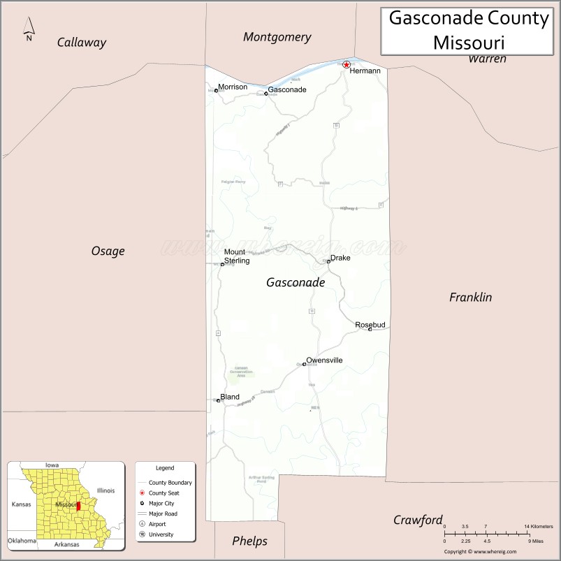
About Gasconade County Map, Missouri: The map showing the county boundary, county seat, major cities, highways, water bodies and neighbouring counties.
Related Missouri Maps & Info
Gasconade County, Missouri
Gasconade County is a county located in the U.S. state of Missouri. It's county seat is Hermann. As per 2020 census, the population of Gasconade County is 14791 people and population density is square miles. According to the United States Census Bureau, the county has a total area of 520 sq mi (1,347 km2). Gasconade County was established on 1821.
Gasconade County Facts
| Continent | North America |
| Country | United States |
| State | Missouri |
| County Seat | Hermann |
| Largest City/Town | Hermann |
| Established | 1820 |
| Total Area | 526 sq mi (1,362 sq km) |
| Land Area | 520 sq mi (1,347 sq km) |
| Water Area | 6 sq mi (15 sq km) |
| Population | 14,674 (Census 2020) |
| Population Density | 28.2 people per sq mi |
| Time Zone | Central Time Zone (CST/CDT) |
| Major Highways | Missouri Route 19, Missouri Route 28, Missouri Route 100, Missouri Route 179 |
| Major Rivers | Missouri River, Gasconade River |
| Neighboring Counties | Montgomery County, Warren County, Franklin County, Osage County, Maries County, Crawford County |
| Famous For | Missouri wine country, German heritage, scenic river valleys, and historic Hermann |
| Top Attractions | Hermann wineries, Deutschheim State Historic Site, Katy Trail nearby region, and Missouri River scenery |
| Official Website | Official Website |
About Gasconade County
Gasconade County is located in east-central Missouri along the Missouri River and was established in 1820. The county seat and largest city is Hermann. The county is widely known for vineyards, German-American culture, riverfront scenery, and historic architecture in the Missouri wine country region.
Cities and Towns in Gasconade County, Missouri
| City/Town | Population (Census 2020) | Latitude & Longitude |
|---|---|---|
| Hermann (county seat) | 2,185 | 38.7048°N, 91.4374°W |
| Owensville | 2,676 | 38.3456°N, 91.5013°W |
| Bland | 539 | 38.3003°N, 91.6388°W |
| Rosebud | 409 | 38.3873°N, 91.3985°W |
| Swiss nearby area | 217 | 38.5278°N, 91.7420°W |
| Morrison | 92 | 38.6681°N, 91.6354°W |
What are the Golf Courses in Gasconade County
| Golf Course | Location | Latitude & Longitude |
|---|---|---|
| Loutre Shore Country Club | Hermann | 38.7135°N, 91.4460°W |
| Owensville Golf Recreation Area | Owensville | 38.3512°N, 91.5108°W |
Major Roads and Highways in Gasconade County
Major highways connect the county with Missouri River communities, wineries, and scenic central Missouri regions.
- Missouri Route 19 - scenic north-south route through river valleys and forests
- Missouri Route 28 - east-west highway serving rural communities
- Missouri Route 100 - route connecting Missouri wine country destinations
- Missouri Route 179 - scenic roadway through rolling countryside and riverfront landscapes
What are Neighboring Counties of Gasconade County
- Montgomery County (north)
- Warren County (northeast)
- Franklin County (east)
- Crawford County (south)
- Maries County (southwest)
- Osage County (west)
What Are the Top Attractions in Gasconade County
The county offers a mix of wineries, historic German culture, river recreation, and scenic countryside attractions.
- Hermann Wineries - wine tasting, vineyard tours, and historic wine cellars
- Deutschheim State Historic Site - preserved German immigrant homes and museum exhibits
- Katy Trail nearby region - biking and hiking trail along the Missouri River corridor
- Missouri River Scenic Overlooks - panoramic views and photography locations
- Historic Downtown Hermann - shops, restaurants, and German-style architecture
- Gasconade River Recreation Areas - fishing, canoeing, kayaking, and camping
- Stone Hill Winery - historic winery and underground wine cellars
- Annual Hermann Festivals - Oktoberfest celebrations and wine-related events
- Rolling Vineyard Scenic Drives - countryside landscapes and river valley scenery
- Local Antique Shops and Museums - exhibits on pioneer settlement and regional heritage
What Is the Distance from Gasconade County to Nearby Cities
The following distances are measured by road (driving).
- Hermann to Jefferson City (Cole County), Missouri - 52 mi (84 km)
- Hermann to St. Louis (St. Louis City), Missouri - 82 mi (132 km)
- Hermann to Columbia (Boone County), Missouri - 91 mi (146 km)
- Hermann to Rolla (Phelps County), Missouri - 59 mi (95 km)
- Hermann to Owensville (Gasconade County), Missouri - 25 mi (40 km)
- Hermann to Bland (Gasconade County), Missouri - 33 mi (53 km)
- Hermann to Springfield (Greene County), Missouri - 182 mi (293 km)
- Hermann to Kansas City (Jackson County), Missouri - 188 mi (303 km)
- Hermann to Branson (Taney County), Missouri - 247 mi (398 km)
- Hermann to Memphis (Shelby County), Tennessee - 318 mi (512 km)
- Hermann to Chicago (Cook County), Illinois - 367 mi (591 km)
- Hermann to Nashville (Davidson County), Tennessee - 366 mi (589 km)
- Hermann to Denver (Denver County), Colorado - 756 mi (1,217 km)
FAQs about Gasconade County
Gasconade County is located in east-central Missouri along the Missouri River.
Gasconade County had a population of 14,674 according to the 2020 United States Census.
Gasconade County is known for Missouri wine country, German heritage, scenic rivers, and historic Hermann.
The county is served by Missouri Route 19, Missouri Route 28, Missouri Route 100, and Missouri Route 179.
Yes, Gasconade County includes golf facilities such as Loutre Shore Country Club and Owensville Golf Recreation Area.
References
- QuickFacts - U.S. Census Bureau
- United States Census Bureau
- United States Geological Survey (USGS)
- National Geodetic Survey
- Official Website
- Adair County Map
- Andrew County Map
- Atchison County Map
- Audrain County Map
- Barry County Map
- Barton County Map
- Bates County Map
- Benton County Map
- Bollinger County Map
- Boone County Map
- Buchanan County Map
- Butler County Map
- Caldwell County Map
- Callaway County Map
- Camden County Map
- Cape Girardeau County Map
- Carroll County Map
- Carter County Map
- Cass County Map
- Cedar County Map
- Chariton County Map
- Christian County Map
- Clark County Map
- Clay County Map
- Clinton County Map
- Cole County Map
- Cooper County Map
- Crawford County Map
- Dade County Map
- Dallas County Map
- Daviess County Map
- DeKalb County Map
- Dent County Map
- Douglas County Map
- Dunklin County Map
- Franklin County Map
- Gasconade County Map
- Gentry County Map
- Greene County Map
- Grundy County Map
- Harrison County Map
- Henry County Map
- Hickory County Map
- Holt County Map
- Howard County Map
- Howell County Map
- Iron County Map
- Jackson County Map
- Jasper County Map
- Jefferson County Map
- Johnson County Map
- Knox County Map
- Laclede County Map
- Lafayette County Map
- Lawrence County Map
- Lewis County Map
- Lincoln County Map
- Linn County Map
- Livingston County Map
- McDonald County Map
- Macon County Map
- Madison County Map
- Maries County Map
- Marion County Map
- Mercer County Map
- Miller County Map
- Mississippi County Map
- Moniteau County Map
- Monroe County Map
- Montgomery County Map
- Morgan County Map
- New Madrid County Map
- Newton County Map
- Nodaway County Map
- Oregon County Map
- Osage County Map
- Ozark County Map
- Pemiscot County Map
- Perry County Map
- Pettis County Map
- Phelps County Map
- Pike County Map
- Platte County Map
- Polk County Map
- Pulaski County Map
- Putnam County Map
- Ralls County Map
- Randolph County Map
- Ray County Map
- Reynolds County Map
- Ripley County Map
- St Charles County Map
- St Clair County Map
- Ste Genevieve County Map
- St Francois County Map
- St Louis County Map
- Saline County Map
- Schuyler County Map
- Scotland County Map
- Scott County Map
- Shannon County Map
- Shelby County Map
- Stoddard County Map
- Stone County Map
- Sullivan County Map
- Taney County Map
- Texas County Map
- Vernon County Map
- Warren County Map
- Washington County Map
- Wayne County Map
- Webster County Map
- Worth County Map
- Wright County Map
- St Louis County Map
- Alabama Counties
- Alaska boroughs
- Arizona Counties
- Arkansas Counties
- California County Map
- Colorado Counties
- Connecticut Counties
- Delaware Counties
- Florida County Map
- Georgia County Map
- Hawaii Counties
- Idaho Counties
- Illinois Counties
- Indiana Counties
- Iowa Counties
- Kansas Counties
- Kentucky Counties
- Louisiana Counties
- Maine Counties
- Maryland Counties
- Massachusetts Counties
- Michigan County Map
- Minnesota Counties
- Mississippi Counties
- Missouri Counties
- Montana Counties
- Nebraska Counties
- Nevada Counties
- New York Counties
- New Hampshire Counties
- New Jersey Counties
- New Mexico Counties
- North Carolina Counties
- North Dakota Counties
- Ohio County Map
- Oklahoma Counties
- Oregon Counties
- Pennsylvania Counties
- Rhode Island Counties
- South Carolina Counties
- South Dakota Counties
- Map of Tennessee
- Texas County Map
- Utah Counties
- Vermont Counties
- Virginia Counties
- Washington Counties
- West Virginia Counties
- Wisconsin Counties
- Wyoming Counties