Map of Benton County - Benton County is a county located in the U.S. state of Missouri. Benton County Map showing cities, highways, important places and water bodies. Get Where is Benton County located in the map, major cities in Benton county, population, areas, and places of interest.
Map of Benton County, Missouri
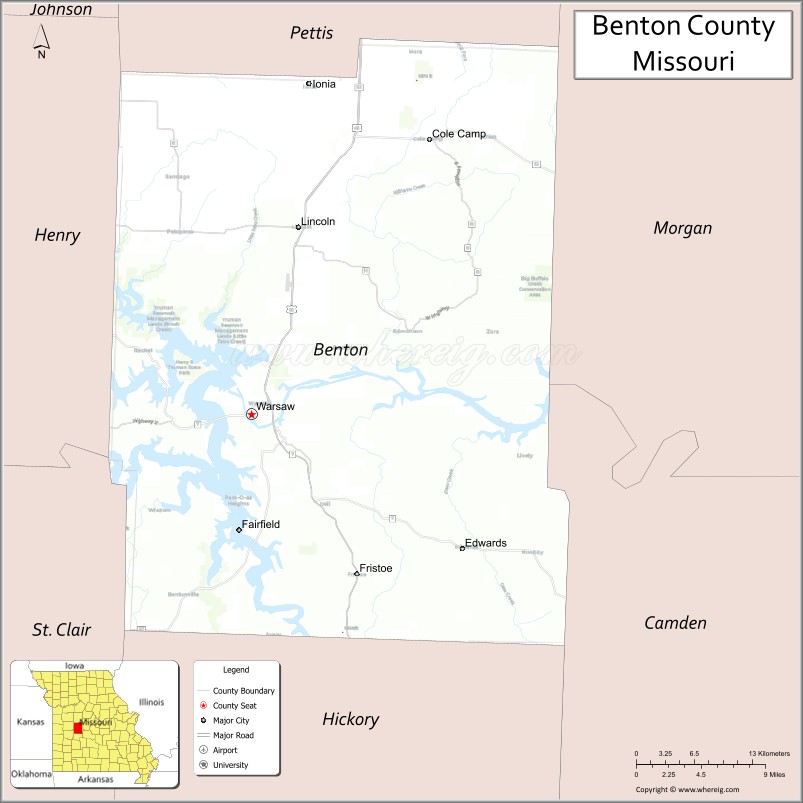
About Benton County Map, Missouri: The map showing the county boundary, county seat, major cities, highways, water bodies and neighbouring counties.
Related Missouri Maps & Info
Benton County, Missouri
Benton County is a county located in the U.S. state of Missouri. It's county seat is Warsaw. As per 2020 census, the population of Benton County is 19908 people and population density is square miles. According to the United States Census Bureau, the county has a total area of 706 sq mi (1,829 km2). Benton County was established on 1835.
Benton County Facts
| Continent | North America |
| Country | United States |
| State | Missouri |
| County Seat | Warsaw |
| Largest City/Town | Warsaw |
| Established | 1835 |
| Total Area | 744 sq mi (1,927 sq km) |
| Land Area | 704 sq mi (1,823 sq km) |
| Water Area | 40 sq mi (104 sq km) |
| Population | 19,394 (Census 2020) |
| Population Density | 27.5 people per sq mi |
| Time Zone | Central Time Zone (CST/CDT) |
| Major Highways | U.S. Route 65, Missouri Route 7, Missouri Route 83 |
| Major Rivers | Osage River, Lake of the Ozarks, Truman Reservoir |
| Neighboring Counties | Morgan County, Camden County, Hickory County, Henry County, Pettis County |
| Famous For | Lake recreation, Truman Dam, fishing, and Ozark outdoor tourism |
| Top Attractions | Harry S Truman State Park, Truman Dam, Lake of the Ozarks nearby region, and Warsaw historic downtown |
| Official Website | Official Website |
About Benton County
Benton County is located in west-central Missouri in the central United States and was established in 1835. The county seat and largest city is Warsaw. The county is known for its lakes, reservoirs, boating, fishing opportunities, and scenic Ozark recreation areas surrounding the Osage River system.
Cities and Towns in Benton County, Missouri
| City/Town | Population (Census 2020) | Latitude & Longitude |
|---|---|---|
| Warsaw (county seat) | 2,127 | 38.2431°N, 93.3810°W |
| Lincoln | 1,095 | 38.3917°N, 93.3349°W |
| Cole Camp | 1,121 | 38.4614°N, 93.2024°W |
| Edwards | 97 | 38.1936°N, 93.2385°W |
| Warsaw West Region | 215 | 38.2507°N, 93.4128°W |
| Cross Timbers nearby area | 119 | 38.0218°N, 93.1937°W |
What are the Golf Courses in Benton County
| Golf Course | Location | Latitude & Longitude |
|---|---|---|
| Shawnee Bend Golf Course | Warsaw | 38.2498°N, 93.3897°W |
| Hidden Valley Golf Club | Cole Camp | 38.4685°N, 93.2089°W |
Major Roads and Highways in Benton County
Major highways connect the county with central Missouri lake communities and Ozark recreation areas.
- U.S. Route 65 - major north-south transportation corridor through Missouri
- Missouri Route 7 - scenic highway serving Lake of the Ozarks regions
- Missouri Route 83 - regional route connecting rural and recreation communities
What are Neighboring Counties of Benton County
- Pettis County (north)
- Morgan County (east)
- Camden County (south)
- Hickory County (southwest)
- Henry County (west)
What Are the Top Attractions in Benton County
The county offers a mix of lake recreation, Ozark scenery, and historical attractions.
- Harry S Truman State Park - camping, hiking, boating, and fishing destination along Truman Reservoir
- Truman Dam - major engineering landmark with scenic overlooks and visitor facilities
- Lake of the Ozarks nearby region - boating, marinas, swimming, and waterfront recreation
- Warsaw Historic Downtown - local shops, restaurants, and historic buildings
- Osage River Recreation Areas - fishing, kayaking, and wildlife observation
- Cole Camp Historic District - German heritage architecture and cultural events
- Benton County Museum - exhibits on pioneer settlement and local history
- Drake Harbor Recreation Area - waterfront park with trails and picnic facilities
- Ozark Scenic Drives - rolling hills, forests, and lake views throughout the county
- Fishing and Camping Areas - outdoor recreation destinations around Truman Reservoir and nearby lakes
What Is the Distance from Benton County to Nearby Cities
The following distances are measured by road (driving).
- Warsaw to Sedalia (Pettis County), Missouri - 42 mi (68 km)
- Warsaw to Springfield (Greene County), Missouri - 101 mi (163 km)
- Warsaw to Jefferson City (Cole County), Missouri - 85 mi (137 km)
- Warsaw to Osage Beach (Camden County), Missouri - 50 mi (80 km)
- Warsaw to Lincoln (Benton County), Missouri - 13 mi (21 km)
- Warsaw to Cole Camp (Benton County), Missouri - 27 mi (43 km)
- Warsaw to Kansas City (Jackson County), Missouri - 96 mi (154 km)
- Warsaw to Columbia (Boone County), Missouri - 107 mi (172 km)
- Warsaw to Saint Louis (St. Louis City), Missouri - 223 mi (359 km)
- Warsaw to Branson (Taney County), Missouri - 151 mi (243 km)
- Warsaw to Tulsa (Tulsa County), Oklahoma - 262 mi (422 km)
- Warsaw to Little Rock (Pulaski County), Arkansas - 313 mi (504 km)
- Warsaw to Denver (Denver County), Colorado - 641 mi (1,032 km)
FAQs about Benton County
Benton County is located in west-central Missouri in the Ozark lake region.
Benton County had a population of 19,394 according to the 2020 United States Census.
Benton County is known for lake recreation, fishing, Truman Dam, and Ozark tourism.
The county is served by U.S. Route 65, Missouri Route 7, and Missouri Route 83.
Yes, Benton County includes golf facilities such as Shawnee Bend Golf Course and Hidden Valley Golf Club.
References
- QuickFacts - U.S. Census Bureau
- United States Census Bureau
- United States Geological Survey (USGS)
- National Geodetic Survey
- Official Website
- Adair County Map
- Andrew County Map
- Atchison County Map
- Audrain County Map
- Barry County Map
- Barton County Map
- Bates County Map
- Benton County Map
- Bollinger County Map
- Boone County Map
- Buchanan County Map
- Butler County Map
- Caldwell County Map
- Callaway County Map
- Camden County Map
- Cape Girardeau County Map
- Carroll County Map
- Carter County Map
- Cass County Map
- Cedar County Map
- Chariton County Map
- Christian County Map
- Clark County Map
- Clay County Map
- Clinton County Map
- Cole County Map
- Cooper County Map
- Crawford County Map
- Dade County Map
- Dallas County Map
- Daviess County Map
- DeKalb County Map
- Dent County Map
- Douglas County Map
- Dunklin County Map
- Franklin County Map
- Gasconade County Map
- Gentry County Map
- Greene County Map
- Grundy County Map
- Harrison County Map
- Henry County Map
- Hickory County Map
- Holt County Map
- Howard County Map
- Howell County Map
- Iron County Map
- Jackson County Map
- Jasper County Map
- Jefferson County Map
- Johnson County Map
- Knox County Map
- Laclede County Map
- Lafayette County Map
- Lawrence County Map
- Lewis County Map
- Lincoln County Map
- Linn County Map
- Livingston County Map
- McDonald County Map
- Macon County Map
- Madison County Map
- Maries County Map
- Marion County Map
- Mercer County Map
- Miller County Map
- Mississippi County Map
- Moniteau County Map
- Monroe County Map
- Montgomery County Map
- Morgan County Map
- New Madrid County Map
- Newton County Map
- Nodaway County Map
- Oregon County Map
- Osage County Map
- Ozark County Map
- Pemiscot County Map
- Perry County Map
- Pettis County Map
- Phelps County Map
- Pike County Map
- Platte County Map
- Polk County Map
- Pulaski County Map
- Putnam County Map
- Ralls County Map
- Randolph County Map
- Ray County Map
- Reynolds County Map
- Ripley County Map
- St Charles County Map
- St Clair County Map
- Ste Genevieve County Map
- St Francois County Map
- St Louis County Map
- Saline County Map
- Schuyler County Map
- Scotland County Map
- Scott County Map
- Shannon County Map
- Shelby County Map
- Stoddard County Map
- Stone County Map
- Sullivan County Map
- Taney County Map
- Texas County Map
- Vernon County Map
- Warren County Map
- Washington County Map
- Wayne County Map
- Webster County Map
- Worth County Map
- Wright County Map
- St Louis County Map
- Alabama Counties
- Alaska boroughs
- Arizona Counties
- Arkansas Counties
- California County Map
- Colorado Counties
- Connecticut Counties
- Delaware Counties
- Florida County Map
- Georgia County Map
- Hawaii Counties
- Idaho Counties
- Illinois Counties
- Indiana Counties
- Iowa Counties
- Kansas Counties
- Kentucky Counties
- Louisiana Counties
- Maine Counties
- Maryland Counties
- Massachusetts Counties
- Michigan County Map
- Minnesota Counties
- Mississippi Counties
- Missouri Counties
- Montana Counties
- Nebraska Counties
- Nevada Counties
- New York Counties
- New Hampshire Counties
- New Jersey Counties
- New Mexico Counties
- North Carolina Counties
- North Dakota Counties
- Ohio County Map
- Oklahoma Counties
- Oregon Counties
- Pennsylvania Counties
- Rhode Island Counties
- South Carolina Counties
- South Dakota Counties
- Map of Tennessee
- Texas County Map
- Utah Counties
- Vermont Counties
- Virginia Counties
- Washington Counties
- West Virginia Counties
- Wisconsin Counties
- Wyoming Counties