Map of Sullivan County - Sullivan County is a county located in the U.S. state of Missouri. Sullivan County Map showing cities, highways, important places and water bodies. Get Where is Sullivan County located in the map, major cities in Sullivan county, population, areas, and places of interest.
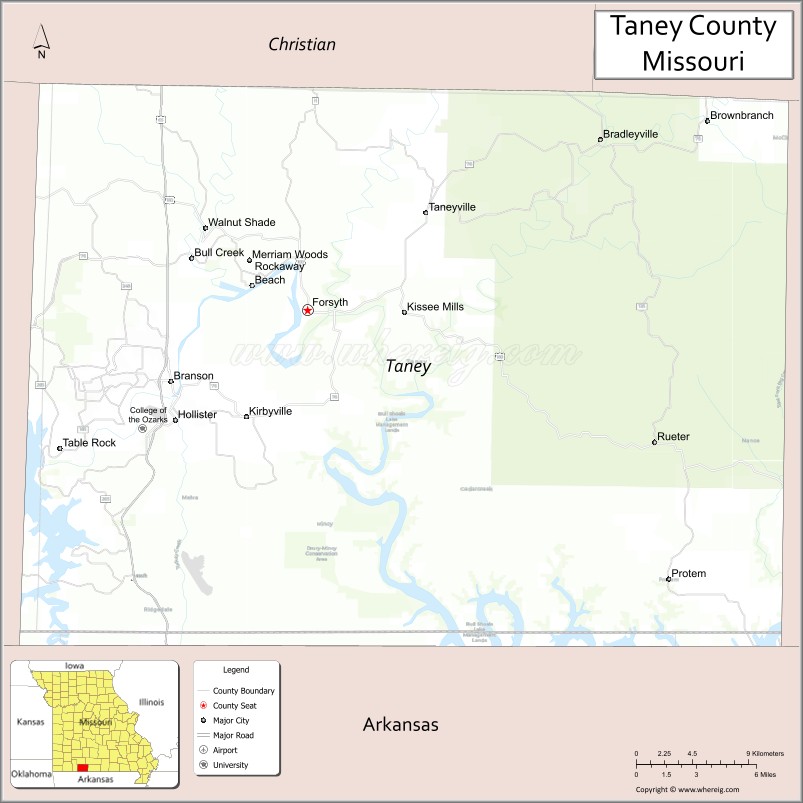
Map of Taney County, Missouri
About Sullivan County Map, Missouri: The map showing the county boundary, county seat, major cities, highways, water bodies and neighbouring counties.
Related Missouri Maps & Info
Taney County, Missouri
Taney County is a county located in the U.S. state of Missouri. It's county seat is Forsyth. As per 2020 census, the population of Taney County is 56387 people and population density is square miles. According to the United States Census Bureau, the county has a total area of 632 sq mi (1,637 km2). Taney County was established on 1837.
Taney County Facts
| Continent | North America |
| Country | United States |
| State | Missouri |
| County Seat | Forsyth |
| Largest City/Town | Branson |
| Established | 1837 |
| Total Area | 632 sq mi (1,637 sq km) |
| Land Area | 632 sq mi (1,637 sq km) |
| Water Area | 0.6 sq mi (1.6 sq km) |
| Population | 56,066 (Census 2020) |
| Population Density | 88.7 people per sq mi |
| Time Zone | Central Time Zone (CST/CDT) |
| Major Highways | U.S. Route 65, Missouri Route 76, Missouri Route 248 |
| Major Rivers | White River, Lake Taneycomo, Bull Shoals Lake nearby region |
| Neighboring Counties | Stone County, Christian County, Ozark County, Boone County (Arkansas), Marion County (Arkansas) |
| Famous For | Branson entertainment, live music theaters, tourism, lakes, and Ozark scenery |
| Top Attractions | Silver Dollar City nearby region, Table Rock Lake nearby region, Branson Landing, and Titanic Museum Attraction |
| Official Website | Official Website |
About Taney County
Taney County is located in southwestern Missouri within the Ozark Mountains and was established in 1837. The county seat is Forsyth, while Branson is the largest city and tourism center. The county is internationally known for live entertainment, lakes, resorts, outdoor recreation, and scenic Ozark landscapes.
Cities and Towns in Taney County, Missouri
| City/Town | Population (Census 2020) | Latitude & Longitude |
|---|---|---|
| Branson | 12,638 | 36.6437°N, 93.2185°W |
| Forsyth (county seat) | 2,686 | 36.6851°N, 93.1191°W |
| Hollister | 4,583 | 36.6167°N, 93.2166°W |
| Merriam Woods | 1,992 | 36.7259°N, 93.1241°W |
| Rockaway Beach | 876 | 36.6998°N, 93.1602°W |
| Kirbyville | 207 | 36.6376°N, 93.0338°W |
What are the Golf Courses in Taney County
| Golf Course | Location | Latitude & Longitude |
|---|---|---|
| Top of the Rock Golf Course | Ridgedale | 36.5255°N, 93.2894°W |
| Branson Hills Golf Club | Branson | 36.6781°N, 93.2006°W |
| Pointe Royale Golf Village | Branson | 36.6039°N, 93.2728°W |
Major Roads and Highways in Taney County
Major highways connect Taney County with Springfield, Arkansas, and the Ozark tourism region.
- U.S. Route 65 - major north-south transportation corridor through Branson
- Missouri Route 76 - entertainment district and scenic Ozark route
- Missouri Route 248 - regional connector serving tourism and residential areas
What are Neighboring Counties of Taney County
- Christian County (north)
- Stone County (west)
- Ozark County (east)
- Boone County, Arkansas (south)
- Marion County, Arkansas (southeast)
What Are the Top Attractions in Taney County
The county offers nationally known entertainment attractions, lakes, golf resorts, and outdoor recreation.
- Branson Entertainment District - live music theaters, shows, restaurants, and shopping
- Silver Dollar City nearby region - theme park with rides, festivals, crafts, and entertainment
- Table Rock Lake nearby region - boating, fishing, camping, and water recreation
- Titanic Museum Attraction - interactive exhibits and maritime history displays
- Branson Landing - waterfront shopping, dining, and entertainment complex
- Lake Taneycomo - trout fishing, kayaking, and scenic recreation
- Top of the Rock Ozarks Heritage Preserve - golf, museums, and scenic overlooks
- Showboat Branson Belle - lake cruises, dining, and live performances
- Ozark Mountain Scenic Drives - rolling hills and panoramic photography opportunities
- Hiking Trails and Nature Parks - outdoor adventure and wildlife observation
What Is the Distance from Taney County to Nearby Cities
The following distances are measured by road (driving).
- Branson to Springfield (Greene County), Missouri - 43 mi (69 km)
- Branson to Harrison (Boone County), Arkansas - 35 mi (56 km)
- Branson to Fayetteville (Washington County), Arkansas - 92 mi (148 km)
- Branson to Joplin (Jasper County), Missouri - 75 mi (121 km)
- Branson to Forsyth (Taney County), Missouri - 9 mi (14 km)
- Branson to Hollister (Taney County), Missouri - 2 mi (3 km)
- Branson to Kansas City (Jackson County), Missouri - 248 mi (399 km)
- Branson to St. Louis (St. Louis City), Missouri - 251 mi (404 km)
- Branson to Tulsa (Tulsa County), Oklahoma - 181 mi (291 km)
- Branson to Little Rock (Pulaski County), Arkansas - 190 mi (306 km)
- Branson to Dallas (Dallas County), Texas - 442 mi (711 km)
- Branson to Memphis (Shelby County), Tennessee - 346 mi (557 km)
- Branson to Denver (Denver County), Colorado - 757 mi (1,218 km)
FAQs about Taney County
Taney County is located in southwestern Missouri within the Ozark Mountains.
Taney County had a population of 56,066 according to the 2020 United States Census.
Taney County is known for Branson entertainment, tourism, lakes, and scenic Ozark recreation.
The county is served by U.S. Route 65, Missouri Route 76, and Missouri Route 248.
Yes, Taney County includes famous golf facilities such as Top of the Rock Golf Course and Branson Hills Golf Club.
References
- QuickFacts - U.S. Census Bureau
- United States Census Bureau
- United States Geological Survey (USGS)
- National Geodetic Survey
- Official Website
- Adair County Map
- Andrew County Map
- Atchison County Map
- Audrain County Map
- Barry County Map
- Barton County Map
- Bates County Map
- Benton County Map
- Bollinger County Map
- Boone County Map
- Buchanan County Map
- Butler County Map
- Caldwell County Map
- Callaway County Map
- Camden County Map
- Cape Girardeau County Map
- Carroll County Map
- Carter County Map
- Cass County Map
- Cedar County Map
- Chariton County Map
- Christian County Map
- Clark County Map
- Clay County Map
- Clinton County Map
- Cole County Map
- Cooper County Map
- Crawford County Map
- Dade County Map
- Dallas County Map
- Daviess County Map
- DeKalb County Map
- Dent County Map
- Douglas County Map
- Dunklin County Map
- Franklin County Map
- Gasconade County Map
- Gentry County Map
- Greene County Map
- Grundy County Map
- Harrison County Map
- Henry County Map
- Hickory County Map
- Holt County Map
- Howard County Map
- Howell County Map
- Iron County Map
- Jackson County Map
- Jasper County Map
- Jefferson County Map
- Johnson County Map
- Knox County Map
- Laclede County Map
- Lafayette County Map
- Lawrence County Map
- Lewis County Map
- Lincoln County Map
- Linn County Map
- Livingston County Map
- McDonald County Map
- Macon County Map
- Madison County Map
- Maries County Map
- Marion County Map
- Mercer County Map
- Miller County Map
- Mississippi County Map
- Moniteau County Map
- Monroe County Map
- Montgomery County Map
- Morgan County Map
- New Madrid County Map
- Newton County Map
- Nodaway County Map
- Oregon County Map
- Osage County Map
- Ozark County Map
- Pemiscot County Map
- Perry County Map
- Pettis County Map
- Phelps County Map
- Pike County Map
- Platte County Map
- Polk County Map
- Pulaski County Map
- Putnam County Map
- Ralls County Map
- Randolph County Map
- Ray County Map
- Reynolds County Map
- Ripley County Map
- St Charles County Map
- St Clair County Map
- Ste Genevieve County Map
- St Francois County Map
- St Louis County Map
- Saline County Map
- Schuyler County Map
- Scotland County Map
- Scott County Map
- Shannon County Map
- Shelby County Map
- Stoddard County Map
- Stone County Map
- Sullivan County Map
- Taney County Map
- Texas County Map
- Vernon County Map
- Warren County Map
- Washington County Map
- Wayne County Map
- Webster County Map
- Worth County Map
- Wright County Map
- St Louis County Map
- Alabama Counties
- Alaska boroughs
- Arizona Counties
- Arkansas Counties
- California County Map
- Colorado Counties
- Connecticut Counties
- Delaware Counties
- Florida County Map
- Georgia County Map
- Hawaii Counties
- Idaho Counties
- Illinois Counties
- Indiana Counties
- Iowa Counties
- Kansas Counties
- Kentucky Counties
- Louisiana Counties
- Maine Counties
- Maryland Counties
- Massachusetts Counties
- Michigan County Map
- Minnesota Counties
- Mississippi Counties
- Missouri Counties
- Montana Counties
- Nebraska Counties
- Nevada Counties
- New York Counties
- New Hampshire Counties
- New Jersey Counties
- New Mexico Counties
- North Carolina Counties
- North Dakota Counties
- Ohio County Map
- Oklahoma Counties
- Oregon Counties
- Pennsylvania Counties
- Rhode Island Counties
- South Carolina Counties
- South Dakota Counties
- Map of Tennessee
- Texas County Map
- Utah Counties
- Vermont Counties
- Virginia Counties
- Washington Counties
- West Virginia Counties
- Wisconsin Counties
- Wyoming Counties