Map of Gentry County - Gentry County is a county located in the U.S. state of Missouri. Gentry County Map showing cities, highways, important places and water bodies. Get Where is Gentry County located in the map, major cities in Gentry county, population, areas, and places of interest.
Map of Gentry County, Missouri
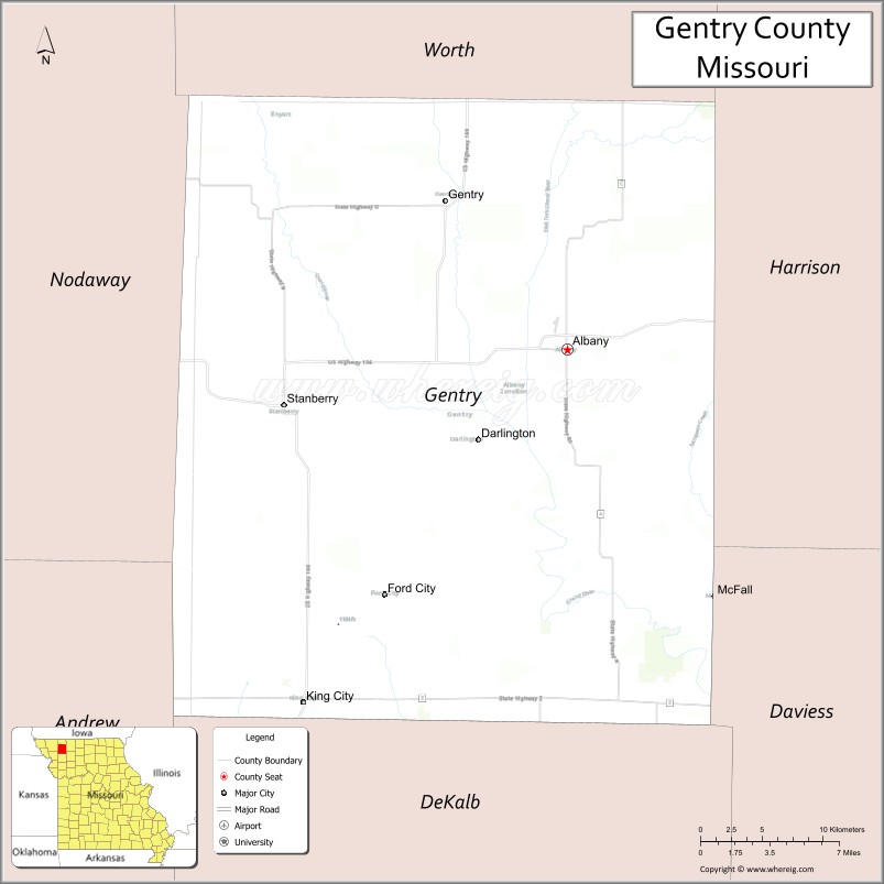
About Gentry County Map, Missouri: The map showing the county boundary, county seat, major cities, highways, water bodies and neighbouring counties.
Related Missouri Maps & Info
Gentry County, Missouri
Gentry County is a county located in the U.S. state of Missouri. It's county seat is Albany. As per 2020 census, the population of Gentry County is 6173 people and population density is square miles. According to the United States Census Bureau, the county has a total area of 492 sq mi (1,274 km2). Gentry County was established on 1841.
Gentry County Facts
| Continent | North America |
| Country | United States |
| State | Missouri |
| County Seat | Albany |
| Largest City/Town | Albany |
| Established | 1841 |
| Total Area | 492 sq mi (1,274 sq km) |
| Land Area | 491 sq mi (1,272 sq km) |
| Water Area | 1 sq mi (2 sq km) |
| Population | 6,162 (Census 2020) |
| Population Density | 12.5 people per sq mi |
| Time Zone | Central Time Zone (CST/CDT) |
| Major Highways | U.S. Route 136, Missouri Route 85, Missouri Route 46 |
| Major Rivers | Grand River, East Fork Grand River |
| Neighboring Counties | Worth County, Harrison County, Daviess County, DeKalb County, Andrew County, Nodaway County |
| Famous For | Agriculture, prairie landscapes, hunting, fishing, and rural northwest Missouri heritage |
| Top Attractions | Albany historic square, Grand River recreation areas, scenic farmland drives, and local conservation areas |
| Official Website | Official Website |
About Gentry County
Gentry County is located in northwestern Missouri near the Iowa border and was established in 1841. The county seat and largest city is Albany. The county is known for agriculture, rolling prairie landscapes, outdoor recreation, and strong rural traditions rooted in farming and small-town communities.
Cities and Towns in Gentry County, Missouri
| City/Town | Population (Census 2020) | Latitude & Longitude |
|---|---|---|
| Albany (county seat) | 1,621 | 40.2483°N, 94.3319°W |
| Stanberry | 1,084 | 40.2150°N, 94.5380°W |
| King City | 995 | 40.0492°N, 94.5241°W |
| Gentry | 67 | 40.3323°N, 94.4216°W |
| Darlington | 82 | 40.2053°N, 94.4022°W |
| Parnell nearby area | 48 | 40.4398°N, 94.6152°W |
What are the Golf Courses in Gentry County
| Golf Course | Location | Latitude & Longitude |
|---|---|---|
| Albany Golf Club | Albany | 40.2557°N, 94.3408°W |
| King City Golf Recreation Area | King City | 40.0554°N, 94.5332°W |
Major Roads and Highways in Gentry County
Major highways connect the county with northern Missouri, Iowa, and regional agricultural communities.
- U.S. Route 136 - major east-west transportation corridor across northern Missouri
- Missouri Route 85 - north-south highway serving rural towns and farmland regions
- Missouri Route 46 - regional transportation route linking local communities
What are Neighboring Counties of Gentry County
- Worth County (north)
- Harrison County (east)
- Daviess County (southeast)
- DeKalb County (south)
- Andrew County (southwest)
- Nodaway County (west)
What Are the Top Attractions in Gentry County
The county offers a mix of prairie scenery, outdoor recreation, and historic small-town attractions.
- Albany Historic Square - courthouse district, local shops, and community events
- Grand River Recreation Areas - fishing, boating, and wildlife observation opportunities
- Northwest Missouri Scenic Drives - rolling farmland and prairie landscapes
- Local Conservation Areas - hunting, hiking, birdwatching, and outdoor recreation
- Stanberry Community Parks - playgrounds, sports facilities, and picnic areas
- King City Historical Attractions - small-town heritage and local museums
- Fishing Lakes and Farm Ponds - popular recreation areas throughout the county
- County Fairs and Agricultural Festivals - celebrations of farming traditions and rural culture
- Wildlife Viewing Areas - habitats for deer, migratory birds, and prairie wildlife
- Historic Rural Churches and Barns - preserved countryside landmarks and architecture
What Is the Distance from Gentry County to Nearby Cities
The following distances are measured by road (driving).
- Albany to St. Joseph (Buchanan County), Missouri - 64 mi (103 km)
- Albany to Kansas City (Jackson County), Missouri - 111 mi (179 km)
- Albany to Maryville (Nodaway County), Missouri - 37 mi (60 km)
- Albany to Bethany (Harrison County), Missouri - 28 mi (45 km)
- Albany to Stanberry (Gentry County), Missouri - 14 mi (23 km)
- Albany to King City (Gentry County), Missouri - 16 mi (26 km)
- Albany to Des Moines (Polk County), Iowa - 131 mi (211 km)
- Albany to Omaha (Douglas County), Nebraska - 138 mi (222 km)
- Albany to Columbia (Boone County), Missouri - 198 mi (319 km)
- Albany to Saint Louis (St. Louis City), Missouri - 340 mi (547 km)
- Albany to Minneapolis (Hennepin County), Minnesota - 399 mi (642 km)
- Albany to Chicago (Cook County), Illinois - 525 mi (845 km)
- Albany to Denver (Denver County), Colorado - 589 mi (948 km)
FAQs about Gentry County
Gentry County is located in northwestern Missouri near the Iowa border.
Gentry County had a population of 6,162 according to the 2020 United States Census.
Gentry County is known for agriculture, prairie landscapes, outdoor recreation, and rural heritage.
The county is served by U.S. Route 136, Missouri Route 85, and Missouri Route 46.
Yes, Gentry County includes golf facilities such as Albany Golf Club and King City Golf Recreation Area.
References
- QuickFacts - U.S. Census Bureau
- United States Census Bureau
- United States Geological Survey (USGS)
- National Geodetic Survey
- Official Website
- Adair County Map
- Andrew County Map
- Atchison County Map
- Audrain County Map
- Barry County Map
- Barton County Map
- Bates County Map
- Benton County Map
- Bollinger County Map
- Boone County Map
- Buchanan County Map
- Butler County Map
- Caldwell County Map
- Callaway County Map
- Camden County Map
- Cape Girardeau County Map
- Carroll County Map
- Carter County Map
- Cass County Map
- Cedar County Map
- Chariton County Map
- Christian County Map
- Clark County Map
- Clay County Map
- Clinton County Map
- Cole County Map
- Cooper County Map
- Crawford County Map
- Dade County Map
- Dallas County Map
- Daviess County Map
- DeKalb County Map
- Dent County Map
- Douglas County Map
- Dunklin County Map
- Franklin County Map
- Gasconade County Map
- Gentry County Map
- Greene County Map
- Grundy County Map
- Harrison County Map
- Henry County Map
- Hickory County Map
- Holt County Map
- Howard County Map
- Howell County Map
- Iron County Map
- Jackson County Map
- Jasper County Map
- Jefferson County Map
- Johnson County Map
- Knox County Map
- Laclede County Map
- Lafayette County Map
- Lawrence County Map
- Lewis County Map
- Lincoln County Map
- Linn County Map
- Livingston County Map
- McDonald County Map
- Macon County Map
- Madison County Map
- Maries County Map
- Marion County Map
- Mercer County Map
- Miller County Map
- Mississippi County Map
- Moniteau County Map
- Monroe County Map
- Montgomery County Map
- Morgan County Map
- New Madrid County Map
- Newton County Map
- Nodaway County Map
- Oregon County Map
- Osage County Map
- Ozark County Map
- Pemiscot County Map
- Perry County Map
- Pettis County Map
- Phelps County Map
- Pike County Map
- Platte County Map
- Polk County Map
- Pulaski County Map
- Putnam County Map
- Ralls County Map
- Randolph County Map
- Ray County Map
- Reynolds County Map
- Ripley County Map
- St Charles County Map
- St Clair County Map
- Ste Genevieve County Map
- St Francois County Map
- St Louis County Map
- Saline County Map
- Schuyler County Map
- Scotland County Map
- Scott County Map
- Shannon County Map
- Shelby County Map
- Stoddard County Map
- Stone County Map
- Sullivan County Map
- Taney County Map
- Texas County Map
- Vernon County Map
- Warren County Map
- Washington County Map
- Wayne County Map
- Webster County Map
- Worth County Map
- Wright County Map
- St Louis County Map
- Alabama Counties
- Alaska boroughs
- Arizona Counties
- Arkansas Counties
- California County Map
- Colorado Counties
- Connecticut Counties
- Delaware Counties
- Florida County Map
- Georgia County Map
- Hawaii Counties
- Idaho Counties
- Illinois Counties
- Indiana Counties
- Iowa Counties
- Kansas Counties
- Kentucky Counties
- Louisiana Counties
- Maine Counties
- Maryland Counties
- Massachusetts Counties
- Michigan County Map
- Minnesota Counties
- Mississippi Counties
- Missouri Counties
- Montana Counties
- Nebraska Counties
- Nevada Counties
- New York Counties
- New Hampshire Counties
- New Jersey Counties
- New Mexico Counties
- North Carolina Counties
- North Dakota Counties
- Ohio County Map
- Oklahoma Counties
- Oregon Counties
- Pennsylvania Counties
- Rhode Island Counties
- South Carolina Counties
- South Dakota Counties
- Map of Tennessee
- Texas County Map
- Utah Counties
- Vermont Counties
- Virginia Counties
- Washington Counties
- West Virginia Counties
- Wisconsin Counties
- Wyoming Counties