Map of Boone County - Boone County is a county located in the U.S. state of Missouri. Boone County Map showing cities, highways, important places and water bodies. Get Where is Boone County located in the map, major cities in Boone county, population, areas, and places of interest.
Map of Boone County, Missouri
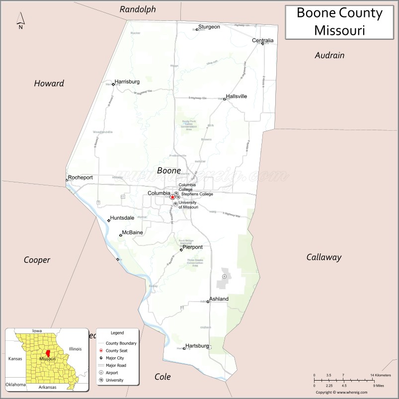
About Boone County Map, Missouri: The map showing the county boundary, county seat, major cities, highways, water bodies and neighbouring counties.
Related Missouri Maps & Info
Boone County, Missouri
Boone County is a county located in the U.S. state of Missouri. It's county seat is Columbia. As per 2020 census, the population of Boone County is 185840 people and population density is square miles. According to the United States Census Bureau, the county has a total area of 685 sq mi (1,774 km2). Boone County was established on 1820.
Boone County Facts
| Continent | North America |
| Country | United States |
| State | Missouri |
| County Seat | Columbia |
| Largest City/Town | Columbia |
| Established | 1820 |
| Total Area | 687 sq mi (1,779 sq km) |
| Land Area | 685 sq mi (1,774 sq km) |
| Water Area | 2 sq mi (5 sq km) |
| Population | 183,610 (Census 2020) |
| Population Density | 268 people per sq mi |
| Time Zone | Central Time Zone (CST/CDT) |
| Major Highways | Interstate 70, U.S. Route 63, U.S. Route 40, Missouri Route 740 |
| Major Rivers | Missouri River, Perche Creek, Hinkson Creek |
| Neighboring Counties | Howard County, Randolph County, Audrain County, Callaway County, Cole County, Cooper County, Moniteau County |
| Famous For | University of Missouri, education, healthcare, cultural events, and Katy Trail nearby region |
| Top Attractions | University of Missouri campus, Rock Bridge Memorial State Park, Mizzou Arena, and downtown Columbia |
| Official Website | Official Website |
About Boone County
Boone County is located in central Missouri in the United States and was established in 1820. The county seat and largest city is Columbia. The county is known for higher education, healthcare services, cultural attractions, sports, and its role as one of Missouri’s major economic and academic centers.
Cities and Towns in Boone County, Missouri
| City/Town | Population (Census 2020) | Latitude & Longitude |
|---|---|---|
| Columbia (county seat) | 126,254 | 38.9517°N, 92.3341°W |
| Ashland | 4,747 | 38.7742°N, 92.2571°W |
| Hallsville | 1,491 | 39.1161°N, 92.2202°W |
| Centralia | 4,394 | 39.2103°N, 92.1371°W |
| Sturgeon | 859 | 39.2336°N, 92.2807°W |
| Rocheport | 208 | 38.9792°N, 92.5635°W |
What are the Golf Courses in Boone County
| Golf Course | Location | Latitude & Longitude |
|---|---|---|
| The Club at Old Hawthorne | Columbia | 38.9355°N, 92.2598°W |
| Columbia Country Club | Columbia | 38.9276°N, 92.3662°W |
| Eagleknoll Golf Course | Hartsburg nearby area | 38.6868°N, 92.3014°W |
Major Roads and Highways in Boone County
Major highways make Boone County a key transportation hub in central Missouri.
- Interstate 70 - major east-west interstate crossing central Missouri
- U.S. Route 63 - important north-south transportation corridor
- U.S. Route 40 - historic route serving local communities and Columbia
- Missouri Route 740 - major route through Columbia metropolitan areas
What are Neighboring Counties of Boone County
- Randolph County (north)
- Audrain County (northeast)
- Callaway County (east)
- Cole County (south)
- Moniteau County (southwest)
- Cooper County (west)
- Howard County (northwest)
What Are the Top Attractions in Boone County
The county offers a mix of educational landmarks, parks, sports venues, and cultural attractions.
- University of Missouri Campus - flagship university with museums, sports, and historic architecture
- Rock Bridge Memorial State Park - caves, hiking trails, forests, and scenic landscapes
- Mizzou Arena - home of University of Missouri basketball and major events
- Downtown Columbia - restaurants, shopping, music venues, and nightlife
- Shelter Gardens - botanical gardens and walking paths in Columbia
- Katy Trail nearby region - popular biking and hiking trail along the Missouri River
- Museum of Art and Archaeology - collections of art and historical artifacts
- Faurot Field at Memorial Stadium - college football venue and campus landmark
- Rocheport Historic District - Missouri River town with wineries and trail access
- Finger Lakes State Park nearby area - ATV trails, camping, and outdoor recreation
What Is the Distance from Boone County to Nearby Cities
The following distances are measured by road (driving).
- Columbia to Jefferson City (Cole County), Missouri - 30 mi (48 km)
- Columbia to Kansas City (Jackson County), Missouri - 126 mi (203 km)
- Columbia to Saint Louis (St. Louis City), Missouri - 125 mi (201 km)
- Columbia to Ashland (Boone County), Missouri - 11 mi (18 km)
- Columbia to Hallsville (Boone County), Missouri - 12 mi (19 km)
- Columbia to Quincy (Adams County), Illinois - 122 mi (196 km)
- Columbia to Tulsa (Tulsa County), Oklahoma - 292 mi (470 km)
- Columbia to Chicago (Cook County), Illinois - 360 mi (579 km)
- Columbia to Memphis (Shelby County), Tennessee - 356 mi (573 km)
- Columbia to Minneapolis (Hennepin County), Minnesota - 512 mi (824 km)
- Columbia to Denver (Denver County), Colorado - 640 mi (1,030 km)
- Columbia to Nashville (Davidson County), Tennessee - 390 mi (628 km)
FAQs about Boone County
Boone County is located in central Missouri and includes the city of Columbia.
Boone County had a population of 183,610 according to the 2020 United States Census.
Boone County is known for the University of Missouri, healthcare, cultural attractions, and education.
The county is served by Interstate 70, U.S. Route 63, U.S. Route 40, and Missouri Route 740.
Yes, Boone County includes golf facilities such as The Club at Old Hawthorne, Columbia Country Club, and Eagleknoll Golf Course.
References
- QuickFacts - U.S. Census Bureau
- United States Census Bureau
- United States Geological Survey (USGS)
- National Geodetic Survey
- Official Website
- Adair County Map
- Andrew County Map
- Atchison County Map
- Audrain County Map
- Barry County Map
- Barton County Map
- Bates County Map
- Benton County Map
- Bollinger County Map
- Boone County Map
- Buchanan County Map
- Butler County Map
- Caldwell County Map
- Callaway County Map
- Camden County Map
- Cape Girardeau County Map
- Carroll County Map
- Carter County Map
- Cass County Map
- Cedar County Map
- Chariton County Map
- Christian County Map
- Clark County Map
- Clay County Map
- Clinton County Map
- Cole County Map
- Cooper County Map
- Crawford County Map
- Dade County Map
- Dallas County Map
- Daviess County Map
- DeKalb County Map
- Dent County Map
- Douglas County Map
- Dunklin County Map
- Franklin County Map
- Gasconade County Map
- Gentry County Map
- Greene County Map
- Grundy County Map
- Harrison County Map
- Henry County Map
- Hickory County Map
- Holt County Map
- Howard County Map
- Howell County Map
- Iron County Map
- Jackson County Map
- Jasper County Map
- Jefferson County Map
- Johnson County Map
- Knox County Map
- Laclede County Map
- Lafayette County Map
- Lawrence County Map
- Lewis County Map
- Lincoln County Map
- Linn County Map
- Livingston County Map
- McDonald County Map
- Macon County Map
- Madison County Map
- Maries County Map
- Marion County Map
- Mercer County Map
- Miller County Map
- Mississippi County Map
- Moniteau County Map
- Monroe County Map
- Montgomery County Map
- Morgan County Map
- New Madrid County Map
- Newton County Map
- Nodaway County Map
- Oregon County Map
- Osage County Map
- Ozark County Map
- Pemiscot County Map
- Perry County Map
- Pettis County Map
- Phelps County Map
- Pike County Map
- Platte County Map
- Polk County Map
- Pulaski County Map
- Putnam County Map
- Ralls County Map
- Randolph County Map
- Ray County Map
- Reynolds County Map
- Ripley County Map
- St Charles County Map
- St Clair County Map
- Ste Genevieve County Map
- St Francois County Map
- St Louis County Map
- Saline County Map
- Schuyler County Map
- Scotland County Map
- Scott County Map
- Shannon County Map
- Shelby County Map
- Stoddard County Map
- Stone County Map
- Sullivan County Map
- Taney County Map
- Texas County Map
- Vernon County Map
- Warren County Map
- Washington County Map
- Wayne County Map
- Webster County Map
- Worth County Map
- Wright County Map
- St Louis County Map
- Alabama Counties
- Alaska boroughs
- Arizona Counties
- Arkansas Counties
- California County Map
- Colorado Counties
- Connecticut Counties
- Delaware Counties
- Florida County Map
- Georgia County Map
- Hawaii Counties
- Idaho Counties
- Illinois Counties
- Indiana Counties
- Iowa Counties
- Kansas Counties
- Kentucky Counties
- Louisiana Counties
- Maine Counties
- Maryland Counties
- Massachusetts Counties
- Michigan County Map
- Minnesota Counties
- Mississippi Counties
- Missouri Counties
- Montana Counties
- Nebraska Counties
- Nevada Counties
- New York Counties
- New Hampshire Counties
- New Jersey Counties
- New Mexico Counties
- North Carolina Counties
- North Dakota Counties
- Ohio County Map
- Oklahoma Counties
- Oregon Counties
- Pennsylvania Counties
- Rhode Island Counties
- South Carolina Counties
- South Dakota Counties
- Map of Tennessee
- Texas County Map
- Utah Counties
- Vermont Counties
- Virginia Counties
- Washington Counties
- West Virginia Counties
- Wisconsin Counties
- Wyoming Counties