Map of Hickory County - Hickory County is a county located in the U.S. state of Missouri. Hickory County Map showing cities, highways, important places and water bodies. Get Where is Hickory County located in the map, major cities in Hickory county, population, areas, and places of interest.
Map of Hickory County, Missouri
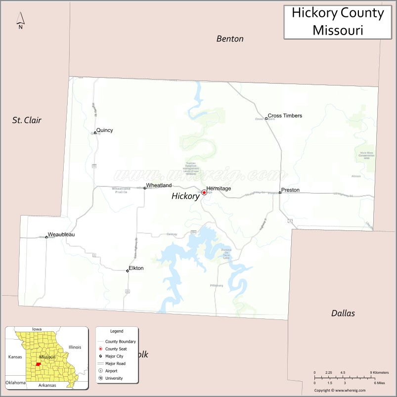
About Hickory County Map, Missouri: The map showing the county boundary, county seat, major cities, highways, water bodies and neighbouring counties.
Related Missouri Maps & Info
Hickory County, Missouri
Hickory County is a county located in the U.S. state of Missouri. It's county seat is Hermitage. As per 2020 census, the population of Hickory County is 8607 people and population density is square miles. According to the United States Census Bureau, the county has a total area of 399 sq mi (1,033 km2). Hickory County was established on 1845.
Hickory County Facts
| Continent | North America |
| Country | United States |
| State | Missouri |
| County Seat | Hermitage |
| Largest City/Town | Hermitage |
| Established | 1845 |
| Total Area | 412 sq mi (1,067 sq km) |
| Land Area | 399 sq mi (1,034 sq km) |
| Water Area | 13 sq mi (33 sq km) |
| Population | 8,279 (Census 2020) |
| Population Density | 20.7 people per sq mi |
| Time Zone | Central Time Zone (CST/CDT) |
| Major Highways | U.S. Route 54, Missouri Route 64, Missouri Route 83 |
| Major Rivers | Pomme de Terre River, Osage River nearby region |
| Neighboring Counties | Camden County, Dallas County, Polk County, Benton County, St. Clair County |
| Famous For | Pomme de Terre Lake recreation, fishing, camping, and Ozark outdoor tourism |
| Top Attractions | Pomme de Terre Lake, Hermitage historic district, state parks nearby region, and fishing resorts |
| Official Website | Official Website |
About Hickory County
Hickory County is located in west-central Missouri in the northern Ozarks and was established in 1845. The county seat and largest city is Hermitage. The county is known for lake recreation, fishing, boating, camping, and scenic landscapes surrounding the Pomme de Terre Lake region.
Cities and Towns in Hickory County, Missouri
| City/Town | Population (Census 2020) | Latitude & Longitude |
|---|---|---|
| Hermitage (county seat) | 641 | 37.9411°N, 93.3171°W |
| Wheatland | 317 | 37.9465°N, 93.3991°W |
| Cross Timbers | 119 | 38.0225°N, 93.2127°W |
| Preston | 213 | 37.9323°N, 93.1788°W |
| Pittsburg | 118 | 37.8287°N, 93.2818°W |
| Quincy nearby area | 39 | 38.0336°N, 93.1454°W |
What are the Golf Courses in Hickory County
| Golf Course | Location | Latitude & Longitude |
|---|---|---|
| Pomme de Terre Golf Course | Hermitage nearby region | 37.9521°N, 93.3344°W |
| Wheatland Golf Recreation Area | Wheatland | 37.9540°N, 93.4082°W |
Major Roads and Highways in Hickory County
Major highways connect the county with central Missouri recreation areas and Ozark communities.
- U.S. Route 54 - important east-west transportation corridor across central Missouri
- Missouri Route 64 - scenic route serving lake recreation areas and rural communities
- Missouri Route 83 - regional highway connecting Ozark towns and outdoor destinations
What are Neighboring Counties of Hickory County
- Camden County (east)
- Dallas County (south)
- Polk County (southwest)
- St. Clair County (west)
- Benton County (north)
What Are the Top Attractions in Hickory County
The county offers lake recreation, scenic Ozark landscapes, and outdoor tourism attractions.
- Pomme de Terre Lake - boating, fishing, swimming, and camping recreation
- Hermitage Historic District - local shops, dining, and small-town attractions
- Pomme de Terre State Park nearby region - hiking trails, marinas, and picnic areas
- Fishing Resorts and Marinas - popular destinations for anglers and lake visitors
- Ozark Scenic Drives - rolling hills, forests, and lake views
- Wildlife Conservation Areas - birdwatching, hiking, and hunting opportunities
- Campgrounds and RV Parks - outdoor accommodations near the lake
- Pomme de Terre River Recreation - kayaking, canoeing, and fishing
- Community Festivals and Lake Events - seasonal celebrations and fishing tournaments
- Nature Photography Locations - scenic overlooks and Ozark countryside landscapes
What Is the Distance from Hickory County to Nearby Cities
The following distances are measured by road (driving).
- Hermitage to Springfield (Greene County), Missouri - 71 mi (114 km)
- Hermitage to Jefferson City (Cole County), Missouri - 87 mi (140 km)
- Hermitage to Kansas City (Jackson County), Missouri - 130 mi (209 km)
- Hermitage to Osage Beach (Camden County), Missouri - 47 mi (76 km)
- Hermitage to Wheatland (Hickory County), Missouri - 7 mi (11 km)
- Hermitage to Preston (Hickory County), Missouri - 9 mi (14 km)
- Hermitage to Branson (Taney County), Missouri - 116 mi (187 km)
- Hermitage to Columbia (Boone County), Missouri - 128 mi (206 km)
- Hermitage to St. Louis (St. Louis City), Missouri - 221 mi (356 km)
- Hermitage to Tulsa (Tulsa County), Oklahoma - 252 mi (406 km)
- Hermitage to Chicago (Cook County), Illinois - 497 mi (800 km)
- Hermitage to Denver (Denver County), Colorado - 654 mi (1,053 km)
- Hermitage to Dallas (Dallas County), Texas - 505 mi (813 km)
FAQs about Hickory County
Hickory County is located in west-central Missouri in the northern Ozarks.
Hickory County had a population of 8,279 according to the 2020 United States Census.
Hickory County is known for Pomme de Terre Lake recreation, fishing, camping, and outdoor tourism.
The county is served by U.S. Route 54, Missouri Route 64, and Missouri Route 83.
Yes, Hickory County includes golf facilities such as Pomme de Terre Golf Course and Wheatland Golf Recreation Area.
References
- QuickFacts - U.S. Census Bureau
- United States Census Bureau
- United States Geological Survey (USGS)
- National Geodetic Survey
- Official Website
- Adair County Map
- Andrew County Map
- Atchison County Map
- Audrain County Map
- Barry County Map
- Barton County Map
- Bates County Map
- Benton County Map
- Bollinger County Map
- Boone County Map
- Buchanan County Map
- Butler County Map
- Caldwell County Map
- Callaway County Map
- Camden County Map
- Cape Girardeau County Map
- Carroll County Map
- Carter County Map
- Cass County Map
- Cedar County Map
- Chariton County Map
- Christian County Map
- Clark County Map
- Clay County Map
- Clinton County Map
- Cole County Map
- Cooper County Map
- Crawford County Map
- Dade County Map
- Dallas County Map
- Daviess County Map
- DeKalb County Map
- Dent County Map
- Douglas County Map
- Dunklin County Map
- Franklin County Map
- Gasconade County Map
- Gentry County Map
- Greene County Map
- Grundy County Map
- Harrison County Map
- Henry County Map
- Hickory County Map
- Holt County Map
- Howard County Map
- Howell County Map
- Iron County Map
- Jackson County Map
- Jasper County Map
- Jefferson County Map
- Johnson County Map
- Knox County Map
- Laclede County Map
- Lafayette County Map
- Lawrence County Map
- Lewis County Map
- Lincoln County Map
- Linn County Map
- Livingston County Map
- McDonald County Map
- Macon County Map
- Madison County Map
- Maries County Map
- Marion County Map
- Mercer County Map
- Miller County Map
- Mississippi County Map
- Moniteau County Map
- Monroe County Map
- Montgomery County Map
- Morgan County Map
- New Madrid County Map
- Newton County Map
- Nodaway County Map
- Oregon County Map
- Osage County Map
- Ozark County Map
- Pemiscot County Map
- Perry County Map
- Pettis County Map
- Phelps County Map
- Pike County Map
- Platte County Map
- Polk County Map
- Pulaski County Map
- Putnam County Map
- Ralls County Map
- Randolph County Map
- Ray County Map
- Reynolds County Map
- Ripley County Map
- St Charles County Map
- St Clair County Map
- Ste Genevieve County Map
- St Francois County Map
- St Louis County Map
- Saline County Map
- Schuyler County Map
- Scotland County Map
- Scott County Map
- Shannon County Map
- Shelby County Map
- Stoddard County Map
- Stone County Map
- Sullivan County Map
- Taney County Map
- Texas County Map
- Vernon County Map
- Warren County Map
- Washington County Map
- Wayne County Map
- Webster County Map
- Worth County Map
- Wright County Map
- St Louis County Map
- Alabama Counties
- Alaska boroughs
- Arizona Counties
- Arkansas Counties
- California County Map
- Colorado Counties
- Connecticut Counties
- Delaware Counties
- Florida County Map
- Georgia County Map
- Hawaii Counties
- Idaho Counties
- Illinois Counties
- Indiana Counties
- Iowa Counties
- Kansas Counties
- Kentucky Counties
- Louisiana Counties
- Maine Counties
- Maryland Counties
- Massachusetts Counties
- Michigan County Map
- Minnesota Counties
- Mississippi Counties
- Missouri Counties
- Montana Counties
- Nebraska Counties
- Nevada Counties
- New York Counties
- New Hampshire Counties
- New Jersey Counties
- New Mexico Counties
- North Carolina Counties
- North Dakota Counties
- Ohio County Map
- Oklahoma Counties
- Oregon Counties
- Pennsylvania Counties
- Rhode Island Counties
- South Carolina Counties
- South Dakota Counties
- Map of Tennessee
- Texas County Map
- Utah Counties
- Vermont Counties
- Virginia Counties
- Washington Counties
- West Virginia Counties
- Wisconsin Counties
- Wyoming Counties