Map of Macon County - Macon County is a county located in the U.S. state of Missouri. Macon County Map showing cities, highways, important places and water bodies. Get Where is Macon County located in the map, major cities in Macon county, population, areas, and places of interest.
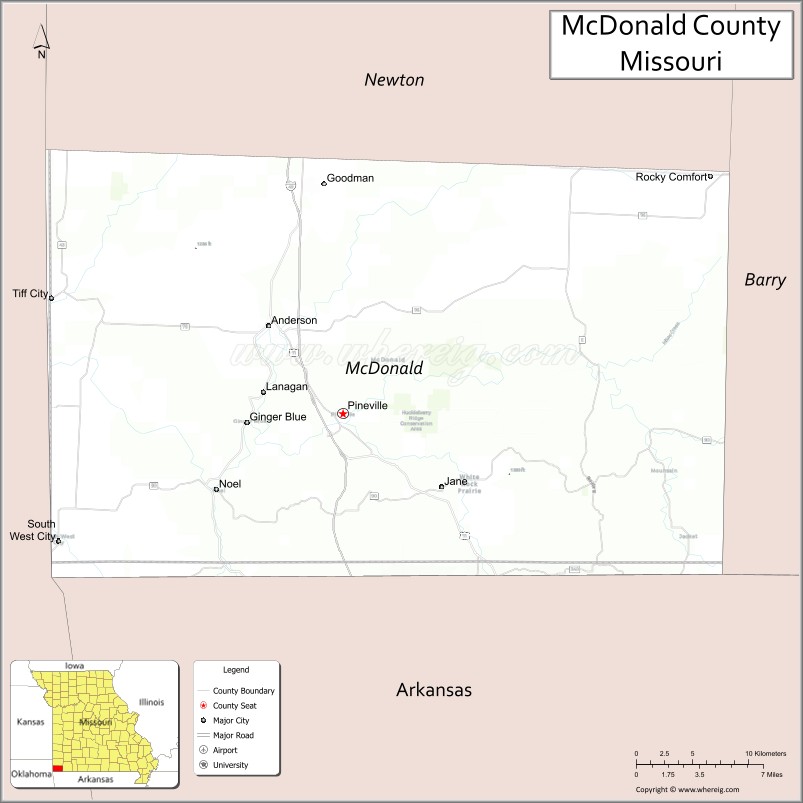
Map of McDonald County, Missouri
About Macon County Map, Missouri: The map showing the county boundary, county seat, major cities, highways, water bodies and neighbouring counties.
Related Missouri Maps & Info
McDonald County, Missouri
McDonald County is a county located in the U.S. state of Missouri. It's county seat is Pineville. As per 2020 census, the population of McDonald County is 23383 people and population density is square miles. According to the United States Census Bureau, the county has a total area of 540 sq mi (1,399 km2). McDonald County was established on 1847.
McDonald County Facts
| Continent | North America |
| Country | United States |
| State | Missouri |
| County Seat | Pineville |
| Largest City/Town | Anderson |
| Established | 1849 |
| Total Area | 540 sq mi (1,399 sq km) |
| Land Area | 539 sq mi (1,396 sq km) |
| Water Area | 1 sq mi (3 sq km) |
| Population | 23,935 (Census 2020) |
| Population Density | 44.4 people per sq mi |
| Time Zone | Central Time Zone (CST/CDT) |
| Major Highways | Interstate 49, U.S. Route 71, Missouri Route 43, Missouri Route 90 |
| Major Rivers | Elk River, Big Sugar Creek |
| Neighboring Counties | Newton County, Barry County, Delaware County (Oklahoma), Benton County (Arkansas) |
| Famous For | Ozark streams, floating recreation, scenic valleys, and outdoor tourism |
| Top Attractions | Elk River recreation, Big Sugar Creek, Noel river activities, and Ozark scenic drives |
| Official Website | Official Website |
About McDonald County
McDonald County is located in the far southwestern corner of Missouri within the Ozarks region and was established in 1849. The county seat is Pineville, while Anderson is the largest city. The county is known for scenic rivers, floating recreation, forested hills, and tourism connected to outdoor adventure activities.
Cities and Towns in McDonald County, Missouri
| City/Town | Population (Census 2020) | Latitude & Longitude |
|---|---|---|
| Anderson | 1,981 | 36.6501°N, 94.4430°W |
| Noel | 1,831 | 36.5459°N, 94.4855°W |
| Pineville (county seat) | 883 | 36.5948°N, 94.3841°W |
| Lanagan | 353 | 36.6064°N, 94.4483°W |
| South West City | 970 | 36.5151°N, 94.6116°W |
| Goodman | 1,248 | 36.7392°N, 94.3997°W |
What are the Golf Courses in McDonald County
| Golf Course | Location | Latitude & Longitude |
|---|---|---|
| Elk River Golf Course | Noel | 36.5547°N, 94.4970°W |
| Anderson Community Golf Area | Anderson | 36.6578°N, 94.4522°W |
| Pineville Recreation Golf Course | Pineville | 36.6035°N, 94.3937°W |
Major Roads and Highways in McDonald County
Major highways connect McDonald County with northwest Arkansas, Oklahoma, and southwest Missouri communities.
- Interstate 49 - major north-south interstate linking Missouri, Arkansas, and Louisiana
- U.S. Route 71 - historic transportation corridor through the Ozarks
- Missouri Route 43 - scenic route serving local communities and recreation areas
- Missouri Route 90 - east-west highway connecting southern Missouri communities
What are Neighboring Counties of McDonald County
- Newton County (north)
- Barry County (northeast)
- Delaware County, Oklahoma (west)
- Benton County, Arkansas (south)
What Are the Top Attractions in McDonald County
The county offers rivers, floating recreation, forests, and scenic Ozark attractions.
- Elk River Recreation Areas - canoeing, kayaking, fishing, and swimming
- Big Sugar Creek - floating trips, camping, and scenic river valleys
- Noel River Tourism Area - tubing, rafting, and summer recreation activities
- Ozark Scenic Drives - rolling hills, forests, and countryside photography locations
- Pineville Historic District - local heritage landmarks and small-town attractions
- Hiking and Wildlife Observation Areas - outdoor recreation and birdwatching opportunities
- Camping and RV Parks - riverfront camping and family recreation
- Community Festivals and Summer River Events - local entertainment and seasonal activities
- Fishing Lakes and Outdoor Parks - recreation and nature exploration
- Nearby Mark Twain National Forest Recreation Areas - hiking and wildlife experiences
What Is the Distance from McDonald County to Nearby Cities
The following distances are measured by road (driving).
- Anderson to Joplin (Jasper County), Missouri - 43 mi (69 km)
- Anderson to Bentonville (Benton County), Arkansas - 32 mi (51 km)
- Anderson to Fayetteville (Washington County), Arkansas - 55 mi (89 km)
- Anderson to Springfield (Greene County), Missouri - 104 mi (167 km)
- Anderson to Noel (McDonald County), Missouri - 10 mi (16 km)
- Anderson to Pineville (McDonald County), Missouri - 8 mi (13 km)
- Anderson to Tulsa (Tulsa County), Oklahoma - 112 mi (180 km)
- Anderson to Kansas City (Jackson County), Missouri - 220 mi (354 km)
- Anderson to Little Rock (Pulaski County), Arkansas - 240 mi (386 km)
- Anderson to St. Louis (St. Louis City), Missouri - 334 mi (537 km)
- Anderson to Dallas (Dallas County), Texas - 361 mi (581 km)
- Anderson to Chicago (Cook County), Illinois - 615 mi (990 km)
- Anderson to Denver (Denver County), Colorado - 701 mi (1,128 km)
FAQs about McDonald County
McDonald County is located in the far southwestern corner of Missouri within the Ozarks region.
McDonald County had a population of 23,935 according to the 2020 United States Census.
McDonald County is known for scenic rivers, floating recreation, forests, and Ozark tourism.
The county is served by Interstate 49, U.S. Route 71, Missouri Route 43, and Missouri Route 90.
Yes, McDonald County includes golf and recreation facilities near Noel, Anderson, and Pineville.
References
- QuickFacts - U.S. Census Bureau
- United States Census Bureau
- United States Geological Survey (USGS)
- National Geodetic Survey
- Official Website
- Adair County Map
- Andrew County Map
- Atchison County Map
- Audrain County Map
- Barry County Map
- Barton County Map
- Bates County Map
- Benton County Map
- Bollinger County Map
- Boone County Map
- Buchanan County Map
- Butler County Map
- Caldwell County Map
- Callaway County Map
- Camden County Map
- Cape Girardeau County Map
- Carroll County Map
- Carter County Map
- Cass County Map
- Cedar County Map
- Chariton County Map
- Christian County Map
- Clark County Map
- Clay County Map
- Clinton County Map
- Cole County Map
- Cooper County Map
- Crawford County Map
- Dade County Map
- Dallas County Map
- Daviess County Map
- DeKalb County Map
- Dent County Map
- Douglas County Map
- Dunklin County Map
- Franklin County Map
- Gasconade County Map
- Gentry County Map
- Greene County Map
- Grundy County Map
- Harrison County Map
- Henry County Map
- Hickory County Map
- Holt County Map
- Howard County Map
- Howell County Map
- Iron County Map
- Jackson County Map
- Jasper County Map
- Jefferson County Map
- Johnson County Map
- Knox County Map
- Laclede County Map
- Lafayette County Map
- Lawrence County Map
- Lewis County Map
- Lincoln County Map
- Linn County Map
- Livingston County Map
- McDonald County Map
- Macon County Map
- Madison County Map
- Maries County Map
- Marion County Map
- Mercer County Map
- Miller County Map
- Mississippi County Map
- Moniteau County Map
- Monroe County Map
- Montgomery County Map
- Morgan County Map
- New Madrid County Map
- Newton County Map
- Nodaway County Map
- Oregon County Map
- Osage County Map
- Ozark County Map
- Pemiscot County Map
- Perry County Map
- Pettis County Map
- Phelps County Map
- Pike County Map
- Platte County Map
- Polk County Map
- Pulaski County Map
- Putnam County Map
- Ralls County Map
- Randolph County Map
- Ray County Map
- Reynolds County Map
- Ripley County Map
- St Charles County Map
- St Clair County Map
- Ste Genevieve County Map
- St Francois County Map
- St Louis County Map
- Saline County Map
- Schuyler County Map
- Scotland County Map
- Scott County Map
- Shannon County Map
- Shelby County Map
- Stoddard County Map
- Stone County Map
- Sullivan County Map
- Taney County Map
- Texas County Map
- Vernon County Map
- Warren County Map
- Washington County Map
- Wayne County Map
- Webster County Map
- Worth County Map
- Wright County Map
- St Louis County Map
- Alabama Counties
- Alaska boroughs
- Arizona Counties
- Arkansas Counties
- California County Map
- Colorado Counties
- Connecticut Counties
- Delaware Counties
- Florida County Map
- Georgia County Map
- Hawaii Counties
- Idaho Counties
- Illinois Counties
- Indiana Counties
- Iowa Counties
- Kansas Counties
- Kentucky Counties
- Louisiana Counties
- Maine Counties
- Maryland Counties
- Massachusetts Counties
- Michigan County Map
- Minnesota Counties
- Mississippi Counties
- Missouri Counties
- Montana Counties
- Nebraska Counties
- Nevada Counties
- New York Counties
- New Hampshire Counties
- New Jersey Counties
- New Mexico Counties
- North Carolina Counties
- North Dakota Counties
- Ohio County Map
- Oklahoma Counties
- Oregon Counties
- Pennsylvania Counties
- Rhode Island Counties
- South Carolina Counties
- South Dakota Counties
- Map of Tennessee
- Texas County Map
- Utah Counties
- Vermont Counties
- Virginia Counties
- Washington Counties
- West Virginia Counties
- Wisconsin Counties
- Wyoming Counties