Map of Iron County - Iron County is a county located in the U.S. state of Missouri. Iron County Map showing cities, highways, important places and water bodies. Get Where is Iron County located in the map, major cities in Iron county, population, areas, and places of interest.
Map of Iron County, Missouri
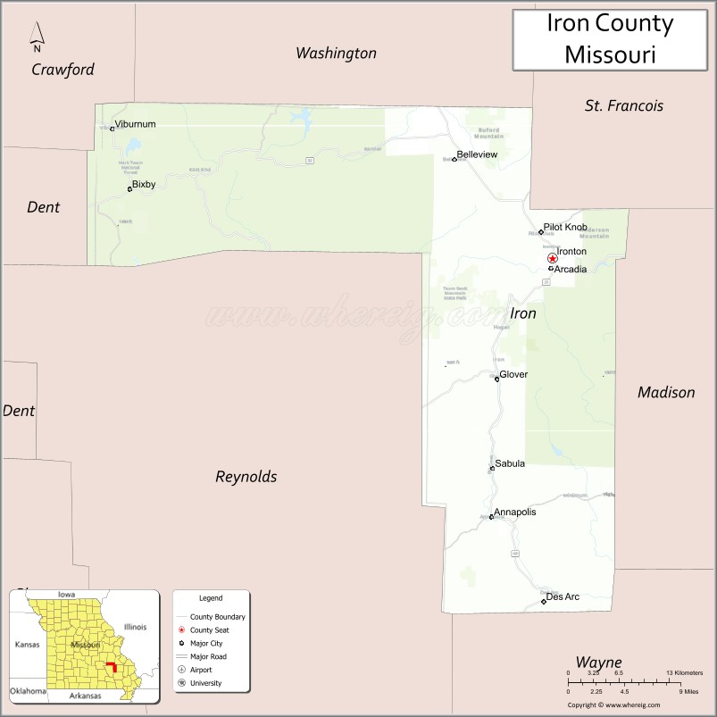
About Iron County Map, Missouri: The map showing the county boundary, county seat, major cities, highways, water bodies and neighbouring counties.
Related Missouri Maps & Info
Iron County, Missouri
Iron County is a county located in the U.S. state of Missouri. It's county seat is Ironton. As per 2020 census, the population of Iron County is 9408 people and population density is square miles. According to the United States Census Bureau, the county has a total area of 551 sq mi (1,427 km2). Iron County was established on 1857.
Iron County Facts
| Continent | North America |
| Country | United States |
| State | Missouri |
| County Seat | Ironton |
| Largest City/Town | Ironton |
| Established | 1857 |
| Total Area | 552 sq mi (1,430 sq km) |
| Land Area | 551 sq mi (1,427 sq km) |
| Water Area | 1 sq mi (3 sq km) |
| Population | 9,537 (Census 2020) |
| Population Density | 17.3 people per sq mi |
| Time Zone | Central Time Zone (CST/CDT) |
| Major Highways | Missouri Route 21, Missouri Route 49, Missouri Route 72 |
| Major Rivers | Black River, Big Creek |
| Neighboring Counties | Washington County, St. Francois County, Madison County, Reynolds County, Dent County, Wayne County |
| Famous For | St. Francois Mountains, mining history, hiking, and Ozark outdoor recreation |
| Top Attractions | Elephant Rocks State Park, Taum Sauk Mountain, Johnson’s Shut-Ins State Park, and Arcadia Valley scenery |
| Official Website | Official Website |
About Iron County
Iron County is located in southeastern Missouri within the Ozark Highlands and was established in 1857. The county seat and largest city is Ironton. The county is known for rugged mountains, historic iron mining, forests, waterfalls, hiking trails, and some of Missouri’s most scenic outdoor recreation areas.
Cities and Towns in Iron County, Missouri
| City/Town | Population (Census 2020) | Latitude & Longitude |
|---|---|---|
| Ironton (county seat) | 1,460 | 37.5970°N, 90.6276°W |
| Arcadia | 608 | 37.5889°N, 90.6229°W |
| Pilot Knob | 746 | 37.6278°N, 90.6426°W |
| Annapolis | 320 | 37.3562°N, 90.6940°W |
| Bixby nearby area | 142 | 37.6608°N, 91.1081°W |
| Viburnum nearby region | 667 | 37.7156°N, 91.1293°W |
What are the Golf Courses in Iron County
| Golf Course | Location | Latitude & Longitude |
|---|---|---|
| Arcadia Valley Country Club | Ironton | 37.6032°N, 90.6351°W |
| Pilot Knob Golf Recreation Area | Pilot Knob | 37.6342°N, 90.6508°W |
Major Roads and Highways in Iron County
Major highways connect the county with the Ozark Highlands, state parks, and southeastern Missouri communities.
- Missouri Route 21 - scenic north-south route through the St. Francois Mountains
- Missouri Route 49 - regional transportation corridor linking Arcadia Valley communities
- Missouri Route 72 - east-west highway connecting recreation areas and rural towns
What are Neighboring Counties of Iron County
- Washington County (north)
- St. Francois County (northeast)
- Madison County (east)
- Wayne County (south)
- Reynolds County (west)
- Dent County (northwest)
What Are the Top Attractions in Iron County
The county offers mountain scenery, waterfalls, state parks, and outdoor recreation throughout the Ozarks.
- Elephant Rocks State Park - giant granite boulders, hiking trails, and picnic areas
- Taum Sauk Mountain - the highest point in Missouri with scenic overlooks and hiking trails
- Johnson’s Shut-Ins State Park - waterfalls, rock formations, swimming areas, and camping
- Arcadia Valley Scenic Region - mountain landscapes, forests, and historic communities
- Fort Davidson State Historic Site - Civil War battlefield and museum exhibits
- Black River Recreation Areas - canoeing, kayaking, fishing, and camping
- Mark Twain National Forest nearby region - hiking, wildlife viewing, and scenic drives
- Arcadia Valley Mountain Music Festival - local music and cultural celebrations
- Historic Mining Heritage Sites - preserved landmarks from Missouri’s iron mining era
- Ozark Scenic Byways - panoramic mountain views and photography locations
What Is the Distance from Iron County to Nearby Cities
The following distances are measured by road (driving).
- Ironton to Farmington (St. Francois County), Missouri - 27 mi (43 km)
- Ironton to Cape Girardeau (Cape Girardeau County), Missouri - 108 mi (174 km)
- Ironton to Poplar Bluff (Butler County), Missouri - 74 mi (119 km)
- Ironton to St. Louis (St. Louis City), Missouri - 96 mi (154 km)
- Ironton to Arcadia (Iron County), Missouri - 2 mi (3 km)
- Ironton to Pilot Knob (Iron County), Missouri - 3 mi (5 km)
- Ironton to Springfield (Greene County), Missouri - 223 mi (359 km)
- Ironton to Branson (Taney County), Missouri - 279 mi (449 km)
- Ironton to Memphis (Shelby County), Tennessee - 257 mi (414 km)
- Ironton to Kansas City (Jackson County), Missouri - 280 mi (451 km)
- Ironton to Chicago (Cook County), Illinois - 370 mi (595 km)
- Ironton to Nashville (Davidson County), Tennessee - 328 mi (528 km)
- Ironton to Denver (Denver County), Colorado - 853 mi (1,373 km)
FAQs about Iron County
Iron County is located in southeastern Missouri within the Ozark Highlands.
Iron County had a population of 9,537 according to the 2020 United States Census.
Iron County is known for the St. Francois Mountains, mining history, hiking, waterfalls, and outdoor recreation.
The county is served by Missouri Route 21, Missouri Route 49, and Missouri Route 72.
Yes, Iron County includes golf facilities such as Arcadia Valley Country Club and Pilot Knob Golf Recreation Area.
References
- QuickFacts - U.S. Census Bureau
- United States Census Bureau
- United States Geological Survey (USGS)
- National Geodetic Survey
- Official Website
- Adair County Map
- Andrew County Map
- Atchison County Map
- Audrain County Map
- Barry County Map
- Barton County Map
- Bates County Map
- Benton County Map
- Bollinger County Map
- Boone County Map
- Buchanan County Map
- Butler County Map
- Caldwell County Map
- Callaway County Map
- Camden County Map
- Cape Girardeau County Map
- Carroll County Map
- Carter County Map
- Cass County Map
- Cedar County Map
- Chariton County Map
- Christian County Map
- Clark County Map
- Clay County Map
- Clinton County Map
- Cole County Map
- Cooper County Map
- Crawford County Map
- Dade County Map
- Dallas County Map
- Daviess County Map
- DeKalb County Map
- Dent County Map
- Douglas County Map
- Dunklin County Map
- Franklin County Map
- Gasconade County Map
- Gentry County Map
- Greene County Map
- Grundy County Map
- Harrison County Map
- Henry County Map
- Hickory County Map
- Holt County Map
- Howard County Map
- Howell County Map
- Iron County Map
- Jackson County Map
- Jasper County Map
- Jefferson County Map
- Johnson County Map
- Knox County Map
- Laclede County Map
- Lafayette County Map
- Lawrence County Map
- Lewis County Map
- Lincoln County Map
- Linn County Map
- Livingston County Map
- McDonald County Map
- Macon County Map
- Madison County Map
- Maries County Map
- Marion County Map
- Mercer County Map
- Miller County Map
- Mississippi County Map
- Moniteau County Map
- Monroe County Map
- Montgomery County Map
- Morgan County Map
- New Madrid County Map
- Newton County Map
- Nodaway County Map
- Oregon County Map
- Osage County Map
- Ozark County Map
- Pemiscot County Map
- Perry County Map
- Pettis County Map
- Phelps County Map
- Pike County Map
- Platte County Map
- Polk County Map
- Pulaski County Map
- Putnam County Map
- Ralls County Map
- Randolph County Map
- Ray County Map
- Reynolds County Map
- Ripley County Map
- St Charles County Map
- St Clair County Map
- Ste Genevieve County Map
- St Francois County Map
- St Louis County Map
- Saline County Map
- Schuyler County Map
- Scotland County Map
- Scott County Map
- Shannon County Map
- Shelby County Map
- Stoddard County Map
- Stone County Map
- Sullivan County Map
- Taney County Map
- Texas County Map
- Vernon County Map
- Warren County Map
- Washington County Map
- Wayne County Map
- Webster County Map
- Worth County Map
- Wright County Map
- St Louis County Map
- Alabama Counties
- Alaska boroughs
- Arizona Counties
- Arkansas Counties
- California County Map
- Colorado Counties
- Connecticut Counties
- Delaware Counties
- Florida County Map
- Georgia County Map
- Hawaii Counties
- Idaho Counties
- Illinois Counties
- Indiana Counties
- Iowa Counties
- Kansas Counties
- Kentucky Counties
- Louisiana Counties
- Maine Counties
- Maryland Counties
- Massachusetts Counties
- Michigan County Map
- Minnesota Counties
- Mississippi Counties
- Missouri Counties
- Montana Counties
- Nebraska Counties
- Nevada Counties
- New York Counties
- New Hampshire Counties
- New Jersey Counties
- New Mexico Counties
- North Carolina Counties
- North Dakota Counties
- Ohio County Map
- Oklahoma Counties
- Oregon Counties
- Pennsylvania Counties
- Rhode Island Counties
- South Carolina Counties
- South Dakota Counties
- Map of Tennessee
- Texas County Map
- Utah Counties
- Vermont Counties
- Virginia Counties
- Washington Counties
- West Virginia Counties
- Wisconsin Counties
- Wyoming Counties