Map of Warren County - Warren County is a county located in the U.S. state of Missouri. Warren County Map showing cities, highways, important places and water bodies. Get Where is Warren County located in the map, major cities in Warren county, population, areas, and places of interest.
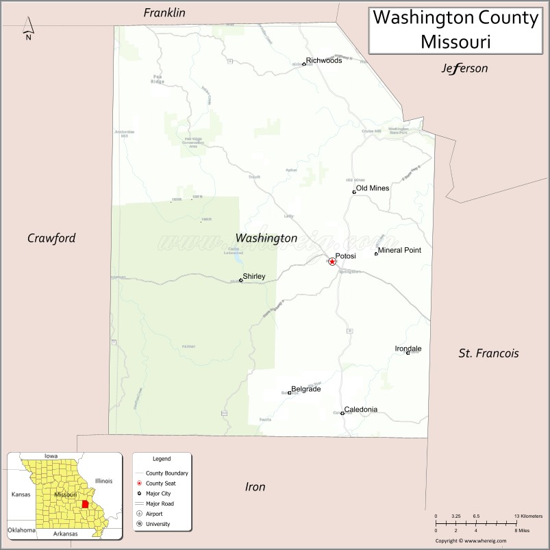
Map of Washington County, Missouri
About Warren County Map, Missouri: The map showing the county boundary, county seat, major cities, highways, water bodies and neighbouring counties.
Related Missouri Maps & Info
Washington County, Missouri
Washington County is a county located in the U.S. state of Missouri. It's county seat is Potosi. As per 2020 census, the population of Washington County is 23502 people and population density is square miles. According to the United States Census Bureau, the county has a total area of 760 sq mi (1,968 km2). Washington County was established on 1813.
Washington County Facts
| Continent | North America |
| Country | United States |
| State | Missouri |
| County Seat | Potosi |
| Largest City/Town | Potosi |
| Established | 1813 |
| Total Area | 762 sq mi (1,973 sq km) |
| Land Area | 760 sq mi (1,968 sq km) |
| Water Area | 2 sq mi (5 sq km) |
| Population | 25,348 (Census 2020) |
| Population Density | 33.4 people per sq mi |
| Time Zone | Central Time Zone (CST/CDT) |
| Major Highways | Missouri Route 21, Missouri Route 8, Missouri Route 47, Missouri Route 185 |
| Major Rivers | Big River, Mineral Fork River |
| Neighboring Counties | Jefferson County, St. Francois County, Iron County, Crawford County, Franklin County, Ste. Genevieve County |
| Famous For | Lead mining history, Ozark scenery, state parks, and outdoor recreation |
| Top Attractions | Mark Twain National Forest, Washington State Park, Elephant Rocks State Park nearby region, and historic Potosi |
| Official Website | Official Website |
About Washington County
Washington County is located in southeastern Missouri within the Ozark Plateau and was established in 1813. The county seat and largest city is Potosi. The county is known for mining heritage, forests, rivers, scenic hills, and outdoor recreation opportunities.
Cities and Towns in Washington County, Missouri
| City/Town | Population (Census 2020) | Latitude & Longitude |
|---|---|---|
| Potosi (county seat) | 2,660 | 37.9367°N, 90.7879°W |
| Mineral Point | 351 | 37.9378°N, 90.7287°W |
| Cadet | 251 | 37.9854°N, 90.7448°W |
| Old Mines | 267 | 38.0253°N, 90.7735°W |
| Caledonia | 130 | 37.7650°N, 90.7740°W |
| Belgrade | 178 | 37.8418°N, 90.8502°W |
What are the Golf Courses in Washington County
| Golf Course | Location | Latitude & Longitude |
|---|---|---|
| Potosi Country Club | Potosi | 37.9465°N, 90.8021°W |
| Fourche Valley Golf Area | Cadet nearby region | 37.9948°N, 90.7579°W |
| Ozark Hills Recreation Golf Area | Mineral Point nearby area | 37.9452°N, 90.7411°W |
Major Roads and Highways in Washington County
Major highways connect Washington County with the Ozark recreation region and eastern Missouri communities.
- Missouri Route 21 - important north-south transportation corridor through the Ozarks
- Missouri Route 8 - east-west highway serving parks and rural towns
- Missouri Route 47 - regional connector linking communities and scenic areas
- Missouri Route 185 - route serving forested and recreational regions
What are Neighboring Counties of Washington County
- Jefferson County (north)
- Ste. Genevieve County (east)
- St. Francois County (southeast)
- Iron County (south)
- Crawford County (west)
- Franklin County (northwest)
What Are the Top Attractions in Washington County
The county offers forests, state parks, mining heritage sites, and outdoor recreation destinations.
- Mark Twain National Forest - hiking, camping, hunting, and scenic recreation
- Washington State Park - trails, camping, and Native American petroglyphs
- Elephant Rocks State Park nearby region - giant granite formations and hiking trails
- Historic Potosi - mining heritage, shops, and local history attractions
- Big River Recreation Areas - fishing, kayaking, and outdoor relaxation
- Council Bluff Lake nearby region - boating, swimming, and camping activities
- Ozark Scenic Drives - rolling hills and countryside photography opportunities
- Community Festivals and Heritage Events - seasonal entertainment and local traditions
- Hunting and Wildlife Areas - deer hunting and wildlife observation
- Historic Mining Communities - preserved lead mining culture and architecture
What Is the Distance from Washington County to Nearby Cities
The following distances are measured by road (driving).
- Potosi to St. Louis (St. Louis City), Missouri - 72 mi (116 km)
- Potosi to Farmington (St. Francois County), Missouri - 29 mi (47 km)
- Potosi to Rolla (Phelps County), Missouri - 69 mi (111 km)
- Potosi to Cape Girardeau (Cape Girardeau County), Missouri - 114 mi (183 km)
- Potosi to Mineral Point (Washington County), Missouri - 4 mi (6 km)
- Potosi to Caledonia (Washington County), Missouri - 16 mi (26 km)
- Potosi to Springfield (Greene County), Missouri - 214 mi (344 km)
- Potosi to Kansas City (Jackson County), Missouri - 274 mi (441 km)
- Potosi to Chicago (Cook County), Illinois - 363 mi (584 km)
- Potosi to Memphis (Shelby County), Tennessee - 287 mi (462 km)
- Potosi to Nashville (Davidson County), Tennessee - 325 mi (523 km)
- Potosi to Dallas (Dallas County), Texas - 618 mi (995 km)
- Potosi to Denver (Denver County), Colorado - 850 mi (1,368 km)
FAQs about Washington County
Washington County is located in southeastern Missouri within the Ozark Plateau.
Washington County had a population of 25,348 according to the 2020 United States Census.
Washington County is known for mining history, forests, state parks, and Ozark outdoor recreation.
The county is served by Missouri Route 21, Missouri Route 8, Missouri Route 47, and Missouri Route 185.
Yes, Washington County includes golf and recreation facilities near Potosi and surrounding Ozark communities.
References
- QuickFacts - U.S. Census Bureau
- United States Census Bureau
- United States Geological Survey (USGS)
- National Geodetic Survey
- Official Website
- Adair County Map
- Andrew County Map
- Atchison County Map
- Audrain County Map
- Barry County Map
- Barton County Map
- Bates County Map
- Benton County Map
- Bollinger County Map
- Boone County Map
- Buchanan County Map
- Butler County Map
- Caldwell County Map
- Callaway County Map
- Camden County Map
- Cape Girardeau County Map
- Carroll County Map
- Carter County Map
- Cass County Map
- Cedar County Map
- Chariton County Map
- Christian County Map
- Clark County Map
- Clay County Map
- Clinton County Map
- Cole County Map
- Cooper County Map
- Crawford County Map
- Dade County Map
- Dallas County Map
- Daviess County Map
- DeKalb County Map
- Dent County Map
- Douglas County Map
- Dunklin County Map
- Franklin County Map
- Gasconade County Map
- Gentry County Map
- Greene County Map
- Grundy County Map
- Harrison County Map
- Henry County Map
- Hickory County Map
- Holt County Map
- Howard County Map
- Howell County Map
- Iron County Map
- Jackson County Map
- Jasper County Map
- Jefferson County Map
- Johnson County Map
- Knox County Map
- Laclede County Map
- Lafayette County Map
- Lawrence County Map
- Lewis County Map
- Lincoln County Map
- Linn County Map
- Livingston County Map
- McDonald County Map
- Macon County Map
- Madison County Map
- Maries County Map
- Marion County Map
- Mercer County Map
- Miller County Map
- Mississippi County Map
- Moniteau County Map
- Monroe County Map
- Montgomery County Map
- Morgan County Map
- New Madrid County Map
- Newton County Map
- Nodaway County Map
- Oregon County Map
- Osage County Map
- Ozark County Map
- Pemiscot County Map
- Perry County Map
- Pettis County Map
- Phelps County Map
- Pike County Map
- Platte County Map
- Polk County Map
- Pulaski County Map
- Putnam County Map
- Ralls County Map
- Randolph County Map
- Ray County Map
- Reynolds County Map
- Ripley County Map
- St Charles County Map
- St Clair County Map
- Ste Genevieve County Map
- St Francois County Map
- St Louis County Map
- Saline County Map
- Schuyler County Map
- Scotland County Map
- Scott County Map
- Shannon County Map
- Shelby County Map
- Stoddard County Map
- Stone County Map
- Sullivan County Map
- Taney County Map
- Texas County Map
- Vernon County Map
- Warren County Map
- Washington County Map
- Wayne County Map
- Webster County Map
- Worth County Map
- Wright County Map
- St Louis County Map
- Alabama Counties
- Alaska boroughs
- Arizona Counties
- Arkansas Counties
- California County Map
- Colorado Counties
- Connecticut Counties
- Delaware Counties
- Florida County Map
- Georgia County Map
- Hawaii Counties
- Idaho Counties
- Illinois Counties
- Indiana Counties
- Iowa Counties
- Kansas Counties
- Kentucky Counties
- Louisiana Counties
- Maine Counties
- Maryland Counties
- Massachusetts Counties
- Michigan County Map
- Minnesota Counties
- Mississippi Counties
- Missouri Counties
- Montana Counties
- Nebraska Counties
- Nevada Counties
- New York Counties
- New Hampshire Counties
- New Jersey Counties
- New Mexico Counties
- North Carolina Counties
- North Dakota Counties
- Ohio County Map
- Oklahoma Counties
- Oregon Counties
- Pennsylvania Counties
- Rhode Island Counties
- South Carolina Counties
- South Dakota Counties
- Map of Tennessee
- Texas County Map
- Utah Counties
- Vermont Counties
- Virginia Counties
- Washington Counties
- West Virginia Counties
- Wisconsin Counties
- Wyoming Counties