Map of Barry County - Barry County is a county located in the U.S. state of Missouri. Barry County Map showing cities, highways, important places and water bodies. Get Where is Barry County located in the map, major cities in Barry county, population, areas, and places of interest.
Map of Barry County, Missouri
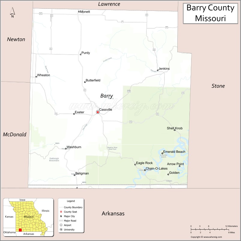
About Barry County Map, Missouri: The map showing the county boundary, county seat, major cities, highways, water bodies and neighbouring counties.
Related Missouri Maps & Info
Barry County, Missouri
Barry County is a county located in the U.S. state of Missouri. It's county seat is Cassville. As per 2020 census, the population of Barry County is 34712 people and population density is square miles. According to the United States Census Bureau, the county has a total area of 779 sq mi (2,018 km2). Barry County was established on 1835.
Barry County Facts
| Continent | North America |
| Country | United States |
| State | Missouri |
| County Seat | Cassville |
| Largest City/Town | Monett (partly in Barry County) |
| Established | 1835 |
| Total Area | 791 sq mi (2,048 sq km) |
| Land Area | 778 sq mi (2,015 sq km) |
| Water Area | 13 sq mi (34 sq km) |
| Population | 34,534 (Census 2020) |
| Population Density | 44.4 people per sq mi |
| Time Zone | Central Time Zone (CST/CDT) |
| Major Highways | U.S. Route 60, Missouri Route 37, Missouri Route 76 |
| Major Rivers | White River, Flat Creek |
| Neighboring Counties | Lawrence County, Stone County, McDonald County, Newton County |
| Famous For | Ozark scenery, Roaring River State Park, trout fishing, and outdoor recreation |
| Top Attractions | Roaring River State Park, Table Rock Lake nearby region, Cassville historic district, and Mark Twain National Forest nearby areas |
| Official Website | Official Website |
About Barry County
Barry County is located in southwestern Missouri in the central United States and was established in 1835. The county seat is Cassville, while Monett is the largest city partly located within the county. The county is known for its Ozark mountain scenery, trout fishing streams, forests, lakes, and year-round outdoor recreation opportunities.
Cities and Towns in Barry County, Missouri
| City/Town | Population (Census 2020) | Latitude & Longitude |
|---|---|---|
| Cassville (county seat) | 3,266 | 36.6776°N, 93.8680°W |
| Monett (partly in Barry County) | 9,576 | 36.9203°N, 93.9277°W |
| Aurora (partly in Barry County) | 7,219 | 36.9709°N, 93.7171°W |
| Purdy | 1,153 | 36.8178°N, 93.9197°W |
| Exeter | 675 | 36.6714°N, 93.9449°W |
| Seligman | 851 | 36.5223°N, 93.9394°W |
What are the Golf Courses in Barry County
| Golf Course | Location | Latitude & Longitude |
|---|---|---|
| Cassville Golf Club | Cassville | 36.6841°N, 93.8745°W |
| Whispering Woods Golf Course | Monett | 36.9267°N, 93.9349°W |
Major Roads and Highways in Barry County
Major highways connect the county with southwest Missouri communities and Ozark recreation destinations.
- U.S. Route 60 - major east-west transportation route through southern Missouri
- Missouri Route 37 - scenic north-south highway through the Ozarks
- Missouri Route 76 - regional route connecting recreation and tourism areas
What are Neighboring Counties of Barry County
- Lawrence County (north)
- Stone County (east)
- McDonald County (southwest)
- Newton County (west)
What Are the Top Attractions in Barry County
The county offers a mix of Ozark landscapes, fishing destinations, and scenic recreation areas.
- Roaring River State Park - nationally known trout fishing, hiking, and camping destination
- Table Rock Lake nearby region - boating, fishing, swimming, and lake recreation area
- Cassville Historic District - downtown shops, restaurants, and historic buildings
- Mark Twain National Forest nearby areas - hiking, wildlife viewing, and forest recreation
- Roaring River Fish Hatchery - popular attraction showcasing trout conservation and hatchery operations
- Flat Creek Recreation Areas - kayaking, fishing, and scenic Ozark landscapes
- Ozark Scenic Drives - winding mountain roads with forest and valley views
- Exeter Community Parks - picnic areas and local outdoor recreation facilities
- Seligman Ozark Countryside - rural scenery and small-town charm
- Southwest Missouri Outdoor Recreation Areas - camping, biking, and wildlife observation destinations
What Is the Distance from Barry County to Nearby Cities
The following distances are measured by road (driving).
- Cassville to Springfield (Greene County), Missouri - 58 mi (93 km)
- Cassville to Branson (Taney County), Missouri - 55 mi (89 km)
- Cassville to Joplin (Jasper County), Missouri - 55 mi (89 km)
- Cassville to Bentonville (Benton County), Arkansas - 53 mi (85 km)
- Cassville to Monett (Barry County), Missouri - 20 mi (32 km)
- Cassville to Exeter (Barry County), Missouri - 6 mi (10 km)
- Cassville to Fayetteville (Washington County), Arkansas - 83 mi (134 km)
- Cassville to Tulsa (Tulsa County), Oklahoma - 145 mi (233 km)
- Cassville to Kansas City (Jackson County), Missouri - 225 mi (362 km)
- Cassville to Saint Louis (St. Louis City), Missouri - 284 mi (457 km)
- Cassville to Little Rock (Pulaski County), Arkansas - 258 mi (415 km)
- Cassville to Memphis (Shelby County), Tennessee - 352 mi (566 km)
- Cassville to Denver (Denver County), Colorado - 739 mi (1,189 km)
FAQs about Barry County
Barry County is located in southwestern Missouri in the Ozark region.
Barry County had a population of 34,534 according to the 2020 United States Census.
Barry County is known for Ozark scenery, trout fishing, Roaring River State Park, and outdoor recreation.
The county is served by U.S. Route 60, Missouri Route 37, and Missouri Route 76.
Yes, Barry County includes golf facilities such as Cassville Golf Club and Whispering Woods Golf Course.
References
- QuickFacts - U.S. Census Bureau
- United States Census Bureau
- United States Geological Survey (USGS)
- National Geodetic Survey
- Official Website
- Adair County Map
- Andrew County Map
- Atchison County Map
- Audrain County Map
- Barry County Map
- Barton County Map
- Bates County Map
- Benton County Map
- Bollinger County Map
- Boone County Map
- Buchanan County Map
- Butler County Map
- Caldwell County Map
- Callaway County Map
- Camden County Map
- Cape Girardeau County Map
- Carroll County Map
- Carter County Map
- Cass County Map
- Cedar County Map
- Chariton County Map
- Christian County Map
- Clark County Map
- Clay County Map
- Clinton County Map
- Cole County Map
- Cooper County Map
- Crawford County Map
- Dade County Map
- Dallas County Map
- Daviess County Map
- DeKalb County Map
- Dent County Map
- Douglas County Map
- Dunklin County Map
- Franklin County Map
- Gasconade County Map
- Gentry County Map
- Greene County Map
- Grundy County Map
- Harrison County Map
- Henry County Map
- Hickory County Map
- Holt County Map
- Howard County Map
- Howell County Map
- Iron County Map
- Jackson County Map
- Jasper County Map
- Jefferson County Map
- Johnson County Map
- Knox County Map
- Laclede County Map
- Lafayette County Map
- Lawrence County Map
- Lewis County Map
- Lincoln County Map
- Linn County Map
- Livingston County Map
- McDonald County Map
- Macon County Map
- Madison County Map
- Maries County Map
- Marion County Map
- Mercer County Map
- Miller County Map
- Mississippi County Map
- Moniteau County Map
- Monroe County Map
- Montgomery County Map
- Morgan County Map
- New Madrid County Map
- Newton County Map
- Nodaway County Map
- Oregon County Map
- Osage County Map
- Ozark County Map
- Pemiscot County Map
- Perry County Map
- Pettis County Map
- Phelps County Map
- Pike County Map
- Platte County Map
- Polk County Map
- Pulaski County Map
- Putnam County Map
- Ralls County Map
- Randolph County Map
- Ray County Map
- Reynolds County Map
- Ripley County Map
- St Charles County Map
- St Clair County Map
- Ste Genevieve County Map
- St Francois County Map
- St Louis County Map
- Saline County Map
- Schuyler County Map
- Scotland County Map
- Scott County Map
- Shannon County Map
- Shelby County Map
- Stoddard County Map
- Stone County Map
- Sullivan County Map
- Taney County Map
- Texas County Map
- Vernon County Map
- Warren County Map
- Washington County Map
- Wayne County Map
- Webster County Map
- Worth County Map
- Wright County Map
- St Louis County Map
- Alabama Counties
- Alaska boroughs
- Arizona Counties
- Arkansas Counties
- California County Map
- Colorado Counties
- Connecticut Counties
- Delaware Counties
- Florida County Map
- Georgia County Map
- Hawaii Counties
- Idaho Counties
- Illinois Counties
- Indiana Counties
- Iowa Counties
- Kansas Counties
- Kentucky Counties
- Louisiana Counties
- Maine Counties
- Maryland Counties
- Massachusetts Counties
- Michigan County Map
- Minnesota Counties
- Mississippi Counties
- Missouri Counties
- Montana Counties
- Nebraska Counties
- Nevada Counties
- New York Counties
- New Hampshire Counties
- New Jersey Counties
- New Mexico Counties
- North Carolina Counties
- North Dakota Counties
- Ohio County Map
- Oklahoma Counties
- Oregon Counties
- Pennsylvania Counties
- Rhode Island Counties
- South Carolina Counties
- South Dakota Counties
- Map of Tennessee
- Texas County Map
- Utah Counties
- Vermont Counties
- Virginia Counties
- Washington Counties
- West Virginia Counties
- Wisconsin Counties
- Wyoming Counties