Map of Camden County - Camden County is a county located in the U.S. state of Missouri. Camden County Map showing cities, highways, important places and water bodies. Get Where is Camden County located in the map, major cities in Camden county, population, areas, and places of interest.
Map of Camden County, Missouri
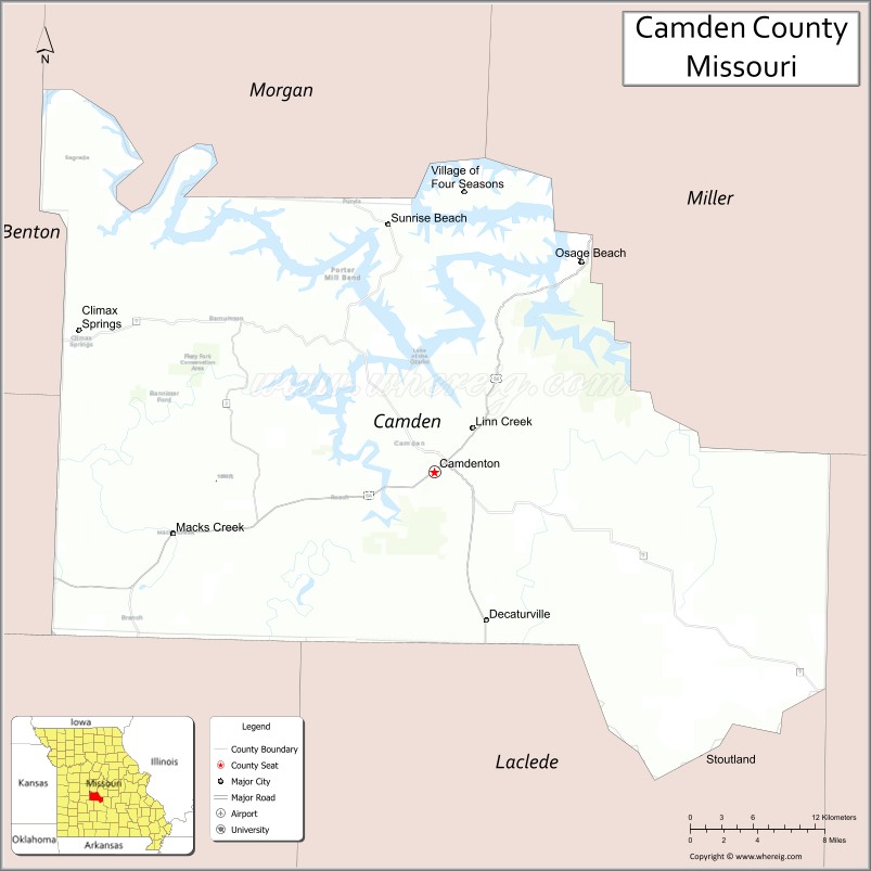
About Camden County Map, Missouri: The map showing the county boundary, county seat, major cities, highways, water bodies and neighbouring counties.
Related Missouri Maps & Info
Camden County, Missouri
Camden County is a county located in the U.S. state of Missouri. It's county seat is Camdenton. As per 2020 census, the population of Camden County is 43436 people and population density is square miles. According to the United States Census Bureau, the county has a total area of 655 sq mi (1,696 km2). Camden County was established on 1841.
Camden County Facts
| Continent | North America |
| Country | United States |
| State | Missouri |
| County Seat | Camdenton |
| Largest City/Town | Lake Ozark (partly in Camden County) |
| Established | 1841 |
| Total Area | 709 sq mi (1,836 sq km) |
| Land Area | 655 sq mi (1,696 sq km) |
| Water Area | 54 sq mi (140 sq km) |
| Population | 42,745 (Census 2020) |
| Population Density | 65.3 people per sq mi |
| Time Zone | Central Time Zone (CST/CDT) |
| Major Highways | U.S. Route 54, Missouri Route 5, Missouri Route 7 |
| Major Rivers | Osage River, Lake of the Ozarks, Niangua River |
| Neighboring Counties | Miller County, Laclede County, Dallas County, Hickory County, Morgan County, Benton County |
| Famous For | Lake of the Ozarks tourism, boating, fishing, golf resorts, and Ozark recreation |
| Top Attractions | Lake of the Ozarks State Park, Ha Ha Tonka State Park, Bridal Cave, and Osage Beach nearby region |
| Official Website | Official Website |
About Camden County
Camden County is located in central Missouri in the Ozarks region of the United States and was established in 1841. The county seat is Camdenton, while Lake Ozark is the largest city partly located within the county. The county is known for Lake of the Ozarks tourism, boating, fishing, resorts, golf courses, and scenic outdoor recreation areas.
Cities and Towns in Camden County, Missouri
| City/Town | Population (Census 2020) | Latitude & Longitude |
|---|---|---|
| Camdenton (county seat) | 4,186 | 38.0086°N, 92.7441°W |
| Lake Ozark (partly in Camden County) | 2,077 | 38.1986°N, 92.6380°W |
| Sunrise Beach | 431 | 38.1769°N, 92.7852°W |
| Linn Creek | 244 | 38.0420°N, 92.7002°W |
| Macks Creek | 244 | 37.9698°N, 92.9657°W |
| Osage Beach nearby area | 4,637 | 38.1503°N, 92.6174°W |
What are the Golf Courses in Camden County
| Golf Course | Location | Latitude & Longitude |
|---|---|---|
| The Lodge of Four Seasons Golf Resort | Lake Ozark | 38.1897°N, 92.6589°W |
| Old Kinderhook Golf Course | Camdenton | 38.0265°N, 92.7720°W |
| Bear Creek Valley Golf Club | Osage Beach nearby region | 38.1471°N, 92.6425°W |
Major Roads and Highways in Camden County
Major highways connect the county with central Missouri and major Lake of the Ozarks tourism destinations.
- U.S. Route 54 - major east-west transportation route through the Lake of the Ozarks region
- Missouri Route 5 - scenic north-south highway through the Ozarks
- Missouri Route 7 - important route connecting lake communities and recreation areas
What are Neighboring Counties of Camden County
- Miller County (north)
- Morgan County (northwest)
- Benton County (west)
- Hickory County (southwest)
- Dallas County (south)
- Laclede County (east)
What Are the Top Attractions in Camden County
The county offers a mix of lake recreation, Ozark scenery, caves, and resort destinations.
- Lake of the Ozarks State Park - Missouri’s largest state park with camping, boating, hiking, and beaches
- Ha Ha Tonka State Park - castle ruins, caves, springs, and scenic hiking trails
- Bridal Cave - famous cave attraction with guided underground tours
- Osage Beach nearby region - shopping, waterfront entertainment, and marinas
- Niangua River Recreation Areas - canoeing, kayaking, and fishing opportunities
- Lake Ozark Waterfront District - restaurants, resorts, nightlife, and lake activities
- Big Surf Waterpark nearby area - family water attractions and entertainment
- Camdenton Historic Downtown - shops, restaurants, and community events
- Ozark Scenic Drives - rolling hills, forests, and lake overlooks
- Fishing and Boating Marinas - popular access points throughout the Lake of the Ozarks region
What Is the Distance from Camden County to Nearby Cities
The following distances are measured by road (driving).
- Camdenton to Jefferson City (Cole County), Missouri - 50 mi (80 km)
- Camdenton to Springfield (Greene County), Missouri - 83 mi (134 km)
- Camdenton to Columbia (Boone County), Missouri - 104 mi (167 km)
- Camdenton to Branson (Taney County), Missouri - 132 mi (212 km)
- Camdenton to Lake Ozark (Camden County), Missouri - 16 mi (26 km)
- Camdenton to Sunrise Beach (Camden County), Missouri - 18 mi (29 km)
- Camdenton to Kansas City (Jackson County), Missouri - 178 mi (286 km)
- Camdenton to Saint Louis (St. Louis City), Missouri - 174 mi (280 km)
- Camdenton to Tulsa (Tulsa County), Oklahoma - 248 mi (399 km)
- Camdenton to Little Rock (Pulaski County), Arkansas - 290 mi (467 km)
- Camdenton to Memphis (Shelby County), Tennessee - 357 mi (575 km)
- Camdenton to Chicago (Cook County), Illinois - 426 mi (686 km)
- Camdenton to Denver (Denver County), Colorado - 689 mi (1,109 km)
FAQs about Camden County
Camden County is located in central Missouri in the Lake of the Ozarks region.
Camden County had a population of 42,745 according to the 2020 United States Census.
Camden County is known for Lake of the Ozarks tourism, boating, fishing, golf resorts, and outdoor recreation.
The county is served by U.S. Route 54, Missouri Route 5, and Missouri Route 7.
Yes, Camden County includes golf facilities such as The Lodge of Four Seasons Golf Resort, Old Kinderhook Golf Course, and Bear Creek Valley Golf Club.
References
- QuickFacts - U.S. Census Bureau
- United States Census Bureau
- United States Geological Survey (USGS)
- National Geodetic Survey
- Official Website
- Adair County Map
- Andrew County Map
- Atchison County Map
- Audrain County Map
- Barry County Map
- Barton County Map
- Bates County Map
- Benton County Map
- Bollinger County Map
- Boone County Map
- Buchanan County Map
- Butler County Map
- Caldwell County Map
- Callaway County Map
- Camden County Map
- Cape Girardeau County Map
- Carroll County Map
- Carter County Map
- Cass County Map
- Cedar County Map
- Chariton County Map
- Christian County Map
- Clark County Map
- Clay County Map
- Clinton County Map
- Cole County Map
- Cooper County Map
- Crawford County Map
- Dade County Map
- Dallas County Map
- Daviess County Map
- DeKalb County Map
- Dent County Map
- Douglas County Map
- Dunklin County Map
- Franklin County Map
- Gasconade County Map
- Gentry County Map
- Greene County Map
- Grundy County Map
- Harrison County Map
- Henry County Map
- Hickory County Map
- Holt County Map
- Howard County Map
- Howell County Map
- Iron County Map
- Jackson County Map
- Jasper County Map
- Jefferson County Map
- Johnson County Map
- Knox County Map
- Laclede County Map
- Lafayette County Map
- Lawrence County Map
- Lewis County Map
- Lincoln County Map
- Linn County Map
- Livingston County Map
- McDonald County Map
- Macon County Map
- Madison County Map
- Maries County Map
- Marion County Map
- Mercer County Map
- Miller County Map
- Mississippi County Map
- Moniteau County Map
- Monroe County Map
- Montgomery County Map
- Morgan County Map
- New Madrid County Map
- Newton County Map
- Nodaway County Map
- Oregon County Map
- Osage County Map
- Ozark County Map
- Pemiscot County Map
- Perry County Map
- Pettis County Map
- Phelps County Map
- Pike County Map
- Platte County Map
- Polk County Map
- Pulaski County Map
- Putnam County Map
- Ralls County Map
- Randolph County Map
- Ray County Map
- Reynolds County Map
- Ripley County Map
- St Charles County Map
- St Clair County Map
- Ste Genevieve County Map
- St Francois County Map
- St Louis County Map
- Saline County Map
- Schuyler County Map
- Scotland County Map
- Scott County Map
- Shannon County Map
- Shelby County Map
- Stoddard County Map
- Stone County Map
- Sullivan County Map
- Taney County Map
- Texas County Map
- Vernon County Map
- Warren County Map
- Washington County Map
- Wayne County Map
- Webster County Map
- Worth County Map
- Wright County Map
- St Louis County Map
- Alabama Counties
- Alaska boroughs
- Arizona Counties
- Arkansas Counties
- California County Map
- Colorado Counties
- Connecticut Counties
- Delaware Counties
- Florida County Map
- Georgia County Map
- Hawaii Counties
- Idaho Counties
- Illinois Counties
- Indiana Counties
- Iowa Counties
- Kansas Counties
- Kentucky Counties
- Louisiana Counties
- Maine Counties
- Maryland Counties
- Massachusetts Counties
- Michigan County Map
- Minnesota Counties
- Mississippi Counties
- Missouri Counties
- Montana Counties
- Nebraska Counties
- Nevada Counties
- New York Counties
- New Hampshire Counties
- New Jersey Counties
- New Mexico Counties
- North Carolina Counties
- North Dakota Counties
- Ohio County Map
- Oklahoma Counties
- Oregon Counties
- Pennsylvania Counties
- Rhode Island Counties
- South Carolina Counties
- South Dakota Counties
- Map of Tennessee
- Texas County Map
- Utah Counties
- Vermont Counties
- Virginia Counties
- Washington Counties
- West Virginia Counties
- Wisconsin Counties
- Wyoming Counties