Map of Knox County - Knox County is a county located in the U.S. state of Missouri. Knox County Map showing cities, highways, important places and water bodies. Get Where is Knox County located in the map, major cities in Knox county, population, areas, and places of interest.
Map of Knox County, Missouri
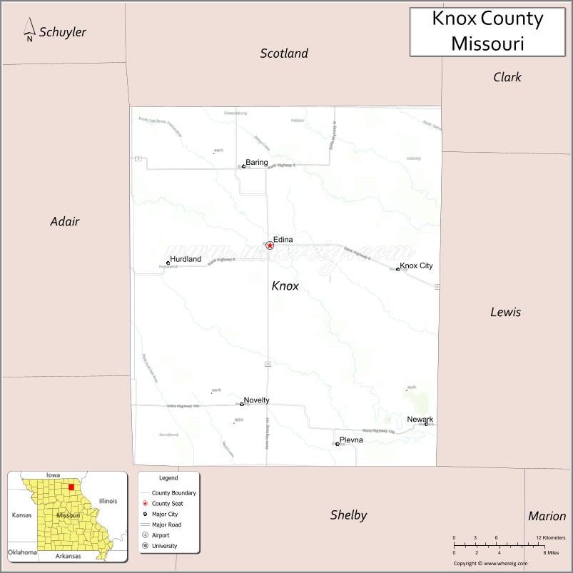
About Knox County Map, Missouri: The map showing the county boundary, county seat, major cities, highways, water bodies and neighbouring counties.
Related Missouri Maps & Info
Knox County, Missouri
Knox County is a county located in the U.S. state of Missouri. It's county seat is Edina. As per 2020 census, the population of Knox County is 3808 people and population density is square miles. According to the United States Census Bureau, the county has a total area of 506 sq mi (1,311 km2). Knox County was established on 1843.
Knox County Facts
| Continent | North America |
| Country | United States |
| State | Missouri |
| County Seat | Edina |
| Largest City/Town | Edina |
| Established | 1845 |
| Total Area | 507 sq mi (1,313 sq km) |
| Land Area | 507 sq mi (1,313 sq km) |
| Water Area | 0.3 sq mi (0.8 sq km) |
| Population | 3,744 (Census 2020) |
| Population Density | 7.4 people per sq mi |
| Time Zone | Central Time Zone (CST/CDT) |
| Major Highways | U.S. Route 63, Missouri Route 6, Missouri Route 15 |
| Major Rivers | North Fork Salt River, Fabius River nearby region |
| Neighboring Counties | Scotland County, Adair County, Macon County, Shelby County, Lewis County, Clark County |
| Famous For | Agriculture, prairie landscapes, rural heritage, and historic small-town communities |
| Top Attractions | Edina historic district, Knox County Fairgrounds, prairie scenery, and local conservation areas |
| Official Website | Official Website |
About Knox County
Knox County is located in northeastern Missouri and was established in 1845. The county seat and largest city is Edina. The county is known for farming, rolling prairie landscapes, outdoor recreation, and historic rural communities that reflect the agricultural traditions of northern Missouri.
Cities and Towns in Knox County, Missouri
| City/Town | Population (Census 2020) | Latitude & Longitude |
|---|---|---|
| Edina (county seat) | 1,012 | 40.1675°N, 92.1724°W |
| Knox City | 191 | 40.1478°N, 92.0062°W |
| Brashear nearby region | 267 | 40.1942°N, 92.3857°W |
| Novelty | 95 | 40.0106°N, 92.2007°W |
| Baring nearby area | 132 | 40.2447°N, 92.2196°W |
| Hurdland nearby region | 164 | 40.1420°N, 92.3013°W |
What are the Golf Courses in Knox County
| Golf Course | Location | Latitude & Longitude |
|---|---|---|
| Knox County Golf Club | Edina | 40.1741°N, 92.1805°W |
| Edina Recreation Golf Area | Edina | 40.1608°N, 92.1657°W |
Major Roads and Highways in Knox County
Major highways connect Knox County with northeastern Missouri agricultural communities and regional trade centers.
- U.S. Route 63 - important north-south transportation corridor through northern Missouri
- Missouri Route 6 - east-west highway connecting rural towns and farmland regions
- Missouri Route 15 - regional transportation route serving local communities
What are Neighboring Counties of Knox County
- Scotland County (north)
- Clark County (northeast)
- Lewis County (east)
- Shelby County (south)
- Macon County (southwest)
- Adair County (west)
What Are the Top Attractions in Knox County
The county offers prairie landscapes, outdoor recreation, and historic rural attractions.
- Edina Historic District - courthouse square, historic buildings, and local businesses
- Knox County Fairgrounds - annual fairs, livestock exhibitions, and community events
- Prairie Scenic Drives - rolling farmland and countryside landscapes
- Local Conservation Areas - hunting, birdwatching, and hiking opportunities
- Fishing Lakes and Farm Ponds - outdoor recreation and nature viewing
- Historic Rural Churches and Barns - preserved agricultural heritage landmarks
- Community Parks and Recreation Facilities - family activities and sports areas
- North Fork Salt River Recreation Areas - fishing and wildlife observation
- Local Museums and Heritage Displays - exhibits on pioneer settlement and farming history
- Seasonal Festivals and Agricultural Celebrations - community traditions and local culture
What Is the Distance from Knox County to Nearby Cities
The following distances are measured by road (driving).
- Edina to Kirksville (Adair County), Missouri - 31 mi (50 km)
- Edina to Quincy (Adams County), Illinois - 63 mi (101 km)
- Edina to Columbia (Boone County), Missouri - 122 mi (196 km)
- Edina to Hannibal (Marion County), Missouri - 58 mi (93 km)
- Edina to Knox City (Knox County), Missouri - 11 mi (18 km)
- Edina to Novelty (Knox County), Missouri - 13 mi (21 km)
- Edina to St. Louis (St. Louis City), Missouri - 202 mi (325 km)
- Edina to Kansas City (Jackson County), Missouri - 216 mi (348 km)
- Edina to Des Moines (Polk County), Iowa - 184 mi (296 km)
- Edina to Chicago (Cook County), Illinois - 344 mi (554 km)
- Edina to Minneapolis (Hennepin County), Minnesota - 408 mi (657 km)
- Edina to Nashville (Davidson County), Tennessee - 448 mi (721 km)
- Edina to Denver (Denver County), Colorado - 715 mi (1,151 km)
FAQs about Knox County
Knox County is located in northeastern Missouri.
Knox County had a population of 3,744 according to the 2020 United States Census.
Knox County is known for agriculture, prairie landscapes, rural heritage, and historic small-town communities.
The county is served by U.S. Route 63, Missouri Route 6, and Missouri Route 15.
Yes, Knox County includes golf facilities such as Knox County Golf Club and Edina Recreation Golf Area.
References
- QuickFacts - U.S. Census Bureau
- United States Census Bureau
- United States Geological Survey (USGS)
- National Geodetic Survey
- Official Website
- Adair County Map
- Andrew County Map
- Atchison County Map
- Audrain County Map
- Barry County Map
- Barton County Map
- Bates County Map
- Benton County Map
- Bollinger County Map
- Boone County Map
- Buchanan County Map
- Butler County Map
- Caldwell County Map
- Callaway County Map
- Camden County Map
- Cape Girardeau County Map
- Carroll County Map
- Carter County Map
- Cass County Map
- Cedar County Map
- Chariton County Map
- Christian County Map
- Clark County Map
- Clay County Map
- Clinton County Map
- Cole County Map
- Cooper County Map
- Crawford County Map
- Dade County Map
- Dallas County Map
- Daviess County Map
- DeKalb County Map
- Dent County Map
- Douglas County Map
- Dunklin County Map
- Franklin County Map
- Gasconade County Map
- Gentry County Map
- Greene County Map
- Grundy County Map
- Harrison County Map
- Henry County Map
- Hickory County Map
- Holt County Map
- Howard County Map
- Howell County Map
- Iron County Map
- Jackson County Map
- Jasper County Map
- Jefferson County Map
- Johnson County Map
- Knox County Map
- Laclede County Map
- Lafayette County Map
- Lawrence County Map
- Lewis County Map
- Lincoln County Map
- Linn County Map
- Livingston County Map
- McDonald County Map
- Macon County Map
- Madison County Map
- Maries County Map
- Marion County Map
- Mercer County Map
- Miller County Map
- Mississippi County Map
- Moniteau County Map
- Monroe County Map
- Montgomery County Map
- Morgan County Map
- New Madrid County Map
- Newton County Map
- Nodaway County Map
- Oregon County Map
- Osage County Map
- Ozark County Map
- Pemiscot County Map
- Perry County Map
- Pettis County Map
- Phelps County Map
- Pike County Map
- Platte County Map
- Polk County Map
- Pulaski County Map
- Putnam County Map
- Ralls County Map
- Randolph County Map
- Ray County Map
- Reynolds County Map
- Ripley County Map
- St Charles County Map
- St Clair County Map
- Ste Genevieve County Map
- St Francois County Map
- St Louis County Map
- Saline County Map
- Schuyler County Map
- Scotland County Map
- Scott County Map
- Shannon County Map
- Shelby County Map
- Stoddard County Map
- Stone County Map
- Sullivan County Map
- Taney County Map
- Texas County Map
- Vernon County Map
- Warren County Map
- Washington County Map
- Wayne County Map
- Webster County Map
- Worth County Map
- Wright County Map
- St Louis County Map
- Alabama Counties
- Alaska boroughs
- Arizona Counties
- Arkansas Counties
- California County Map
- Colorado Counties
- Connecticut Counties
- Delaware Counties
- Florida County Map
- Georgia County Map
- Hawaii Counties
- Idaho Counties
- Illinois Counties
- Indiana Counties
- Iowa Counties
- Kansas Counties
- Kentucky Counties
- Louisiana Counties
- Maine Counties
- Maryland Counties
- Massachusetts Counties
- Michigan County Map
- Minnesota Counties
- Mississippi Counties
- Missouri Counties
- Montana Counties
- Nebraska Counties
- Nevada Counties
- New York Counties
- New Hampshire Counties
- New Jersey Counties
- New Mexico Counties
- North Carolina Counties
- North Dakota Counties
- Ohio County Map
- Oklahoma Counties
- Oregon Counties
- Pennsylvania Counties
- Rhode Island Counties
- South Carolina Counties
- South Dakota Counties
- Map of Tennessee
- Texas County Map
- Utah Counties
- Vermont Counties
- Virginia Counties
- Washington Counties
- West Virginia Counties
- Wisconsin Counties
- Wyoming Counties