Map of Johnson County - Johnson County is a county located in the U.S. state of Missouri. Johnson County Map showing cities, highways, important places and water bodies. Get Where is Johnson County located in the map, major cities in Johnson county, population, areas, and places of interest.
Map of Johnson County, Missouri
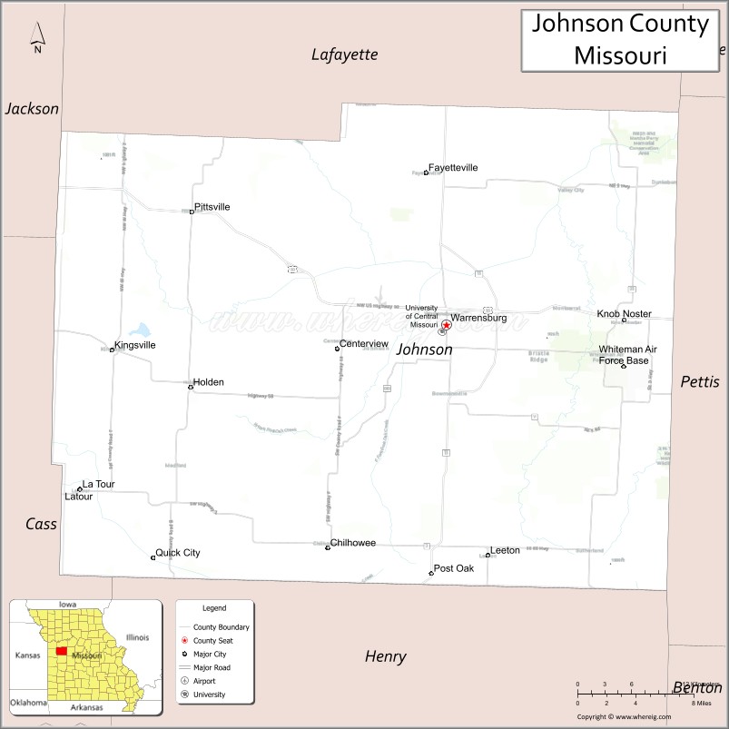
About Johnson County Map, Missouri: The map showing the county boundary, county seat, major cities, highways, water bodies and neighbouring counties.
Related Missouri Maps & Info
Johnson County, Missouri
Johnson County is a county located in the U.S. state of Missouri. It's county seat is Warrensburg. As per 2020 census, the population of Johnson County is 54150 people and population density is square miles. According to the United States Census Bureau, the county has a total area of 831 sq mi (2,152 km2). Johnson County was established on 1834.
Johnson County Facts
| Continent | North America |
| Country | United States |
| State | Missouri |
| County Seat | Warrensburg |
| Largest City/Town | Warrensburg |
| Established | 1834 |
| Total Area | 833 sq mi (2,157 sq km) |
| Land Area | 829 sq mi (2,147 sq km) |
| Water Area | 4 sq mi (10 sq km) |
| Population | 54,013 (Census 2020) |
| Population Density | 65.2 people per sq mi |
| Time Zone | Central Time Zone (CST/CDT) |
| Major Highways | U.S. Route 50, Missouri Route 13, Missouri Route 23, Missouri Route 58 |
| Major Rivers | Blackwater River, Big Creek |
| Neighboring Counties | Lafayette County, Pettis County, Henry County, Cass County, Jackson County, Saline County |
| Famous For | University of Central Missouri, Whiteman Air Force Base nearby region, and agricultural heritage |
| Top Attractions | University of Central Missouri campus, Pertle Springs, historical downtown Warrensburg, and Knob Noster State Park nearby region |
| Official Website | Official Website |
About Johnson County
Johnson County is located in west-central Missouri and was established in 1834. The county seat and largest city is Warrensburg. The county is known for higher education, military connections, agriculture, historic communities, and scenic countryside located between Kansas City and central Missouri.
Cities and Towns in Johnson County, Missouri
| City/Town | Population (Census 2020) | Latitude & Longitude |
|---|---|---|
| Warrensburg (county seat) | 20,891 | 38.7628°N, 93.7360°W |
| Knob Noster | 2,782 | 38.7661°N, 93.5583°W |
| Holden | 2,156 | 38.7153°N, 93.9916°W |
| Centerview | 267 | 38.7456°N, 93.8591°W |
| Leeton | 573 | 38.5847°N, 93.6949°W |
| Chilhowee | 334 | 38.5922°N, 93.8530°W |
What are the Golf Courses in Johnson County
| Golf Course | Location | Latitude & Longitude |
|---|---|---|
| Mules National Golf Club | Warrensburg | 38.7761°N, 93.7482°W |
| Knob Noster Golf Course | Knob Noster | 38.7734°N, 93.5657°W |
| Hidden Pines Country Club | Holden | 38.7240°N, 94.0021°W |
Major Roads and Highways in Johnson County
Major highways connect Johnson County with Kansas City, Sedalia, and important west-central Missouri communities.
- U.S. Route 50 - major east-west transportation corridor across Missouri
- Missouri Route 13 - north-south highway linking agricultural and commercial centers
- Missouri Route 23 - regional route connecting rural communities
- Missouri Route 58 - important local transportation corridor
What are Neighboring Counties of Johnson County
- Lafayette County (north)
- Saline County (northeast)
- Pettis County (east)
- Henry County (south)
- Cass County (west)
- Jackson County (northwest)
What Are the Top Attractions in Johnson County
The county offers educational attractions, outdoor recreation, historic districts, and scenic countryside destinations.
- University of Central Missouri - historic campus, museums, and educational events
- Pertle Springs Recreation Area - trails, lakes, and outdoor activities near Warrensburg
- Downtown Warrensburg Historic District - shops, restaurants, and historic architecture
- Knob Noster State Park nearby region - hiking, camping, and wildlife observation
- Whiteman Air Force Base nearby region - military history and aviation heritage
- Johnson County Historical Society Museum - exhibits on pioneer settlement and local culture
- Rock Island Trail State Park nearby region - biking and hiking opportunities
- Community Festivals and Fairs - agricultural celebrations and seasonal events
- Blackwater River Recreation Areas - fishing, kayaking, and nature viewing
- Scenic Prairie and Farmland Drives - rolling countryside landscapes and photography locations
What Is the Distance from Johnson County to Nearby Cities
The following distances are measured by road (driving).
- Warrensburg to Kansas City (Jackson County), Missouri - 57 mi (92 km)
- Warrensburg to Sedalia (Pettis County), Missouri - 29 mi (47 km)
- Warrensburg to Columbia (Boone County), Missouri - 96 mi (154 km)
- Warrensburg to Knob Noster (Johnson County), Missouri - 10 mi (16 km)
- Warrensburg to Holden (Johnson County), Missouri - 18 mi (29 km)
- Warrensburg to Springfield (Greene County), Missouri - 147 mi (237 km)
- Warrensburg to St. Louis (St. Louis City), Missouri - 247 mi (398 km)
- Warrensburg to Wichita (Sedgwick County), Kansas - 257 mi (414 km)
- Warrensburg to Omaha (Douglas County), Nebraska - 229 mi (369 km)
- Warrensburg to Chicago (Cook County), Illinois - 520 mi (837 km)
- Warrensburg to Denver (Denver County), Colorado - 608 mi (979 km)
- Warrensburg to Dallas (Dallas County), Texas - 531 mi (855 km)
FAQs about Johnson County
Johnson County is located in west-central Missouri.
Johnson County had a population of 54,013 according to the 2020 United States Census.
Johnson County is known for the University of Central Missouri, nearby Whiteman Air Force Base, and agricultural heritage.
The county is served by U.S. Route 50, Missouri Route 13, Missouri Route 23, and Missouri Route 58.
Yes, Johnson County includes golf facilities such as Mules National Golf Club, Knob Noster Golf Course, and Hidden Pines Country Club.