Map of Jasper County - Jasper County is a county located in the U.S. state of Missouri. Jasper County Map showing cities, highways, important places and water bodies. Get Where is Jasper County located in the map, major cities in Jasper county, population, areas, and places of interest.
Map of Jasper County, Missouri
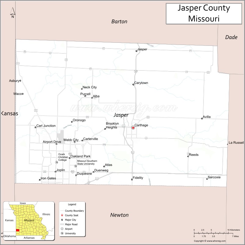
About Jasper County Map, Missouri: The map showing the county boundary, county seat, major cities, highways, water bodies and neighbouring counties.
Related Missouri Maps & Info
Jasper County, Missouri
Jasper County is a county located in the U.S. state of Missouri. It's county seat is Carthage. As per 2020 census, the population of Jasper County is 123155 people and population density is square miles. According to the United States Census Bureau, the county has a total area of 640 sq mi (1,658 km2). Jasper County was established on 1841.
Jasper County Facts
| Continent | North America |
| Country | United States |
| State | Missouri |
| County Seat | Carthage |
| Largest City/Town | Joplin |
| Established | 1841 |
| Total Area | 641 sq mi (1,660 sq km) |
| Land Area | 638 sq mi (1,652 sq km) |
| Water Area | 3 sq mi (8 sq km) |
| Population | 122,761 (Census 2020) |
| Population Density | 192.4 people per sq mi |
| Time Zone | Central Time Zone (CST/CDT) |
| Major Highways | Interstate 44, Interstate 49, U.S. Route 71, U.S. Route 166, Missouri Route 96 |
| Major Rivers | Spring River, Shoal Creek |
| Neighboring Counties | Newton County, Barton County, Dade County, Lawrence County, Cherokee County (Kansas), Crawford County (Kansas) |
| Famous For | Joplin city, Route 66 history, mining heritage, and regional commerce |
| Top Attractions | Grand Falls, Precious Moments Chapel nearby region, Route 66 attractions, and historic Carthage |
| Official Website | Official Website |
About Jasper County
Jasper County is located in southwestern Missouri near the Kansas and Oklahoma borders and was established in 1841. The county seat is Carthage, while Joplin is the largest city. The county is known for mining history, transportation routes, healthcare, manufacturing, and being a major commercial center in the Four States region.
Cities and Towns in Jasper County, Missouri
| City/Town | Population (Census 2020) | Latitude & Longitude |
|---|---|---|
| Joplin | 51,762 | 37.0842°N, 94.5133°W |
| Carthage (county seat) | 15,029 | 37.1764°N, 94.3102°W |
| Webb City | 13,213 | 37.1464°N, 94.4630°W |
| Carl Junction | 8,555 | 37.1767°N, 94.5652°W |
| Oronogo | 1,249 | 37.1895°N, 94.4702°W |
| Duquesne | 1,743 | 37.0737°N, 94.4697°W |
What are the Golf Courses in Jasper County
| Golf Course | Location | Latitude & Longitude |
|---|---|---|
| Schifferdecker Golf Course | Joplin | 37.0987°N, 94.5360°W |
| Precious Moments Golf Course nearby region | Carthage | 37.1831°N, 94.3204°W |
| Briarbrook Golf Course | Carl Junction | 37.1662°N, 94.5751°W |
Major Roads and Highways in Jasper County
Major highways make Jasper County an important transportation and commercial hub in southwest Missouri.
- Interstate 44 - major east-west interstate linking Missouri and Oklahoma
- Interstate 49 - north-south transportation corridor connecting Kansas City and Arkansas
- U.S. Route 71 - regional highway through the Joplin metropolitan area
- U.S. Route 166 - route connecting Missouri with Kansas and Oklahoma
- Missouri Route 96 - historic Route 66 corridor through Jasper County
What are Neighboring Counties of Jasper County
- Barton County (north)
- Dade County (northeast)
- Lawrence County (east)
- Newton County (south)
- Cherokee County, Kansas (west)
- Crawford County, Kansas (northwest)
What Are the Top Attractions in Jasper County
The county offers historic landmarks, outdoor recreation, entertainment districts, and Route 66 attractions.
- Grand Falls - large natural waterfall and scenic recreation area near Joplin
- Route 66 Historic Attractions - classic roadside landmarks and historic districts
- Historic Downtown Carthage - Victorian architecture, shops, and museums
- Precious Moments Chapel nearby region - famous inspirational art and chapel complex
- Joplin History and Mineral Museum - mining heritage and regional history exhibits
- Wildcat Glades Conservation and Audubon Center - hiking trails and wildlife viewing
- George Washington Carver National Monument nearby region - historical exhibits and nature trails
- Cunningham Park and Local Recreation Areas - community sports and family activities
- Spiva Center for the Arts - galleries, cultural events, and performances
- Four States Entertainment Districts - restaurants, shopping, and nightlife attractions
What Is the Distance from Jasper County to Nearby Cities
The following distances are measured by road (driving).
- Joplin to Springfield (Greene County), Missouri - 71 mi (114 km)
- Joplin to Tulsa (Tulsa County), Oklahoma - 116 mi (187 km)
- Joplin to Kansas City (Jackson County), Missouri - 159 mi (256 km)
- Joplin to Branson (Taney County), Missouri - 118 mi (190 km)
- Joplin to Carthage (Jasper County), Missouri - 15 mi (24 km)
- Joplin to Webb City (Jasper County), Missouri - 6 mi (10 km)
- Joplin to Fayetteville (Washington County), Arkansas - 93 mi (150 km)
- Joplin to St. Louis (St. Louis City), Missouri - 283 mi (455 km)
- Joplin to Little Rock (Pulaski County), Arkansas - 245 mi (394 km)
- Joplin to Dallas (Dallas County), Texas - 338 mi (544 km)
- Joplin to Chicago (Cook County), Illinois - 557 mi (896 km)
- Joplin to Denver (Denver County), Colorado - 627 mi (1,009 km)
- Joplin to Memphis (Shelby County), Tennessee - 362 mi (583 km)
FAQs about Jasper County
Jasper County is located in southwestern Missouri near the Kansas and Oklahoma borders.
Jasper County had a population of 122,761 according to the 2020 United States Census.
Jasper County is known for Joplin, Route 66 history, mining heritage, and regional commerce.
The county is served by Interstate 44, Interstate 49, U.S. Route 71, U.S. Route 166, and Missouri Route 96.
Yes, Jasper County includes golf facilities such as Schifferdecker Golf Course, Briarbrook Golf Course, and nearby recreation courses around Carthage.
References
- QuickFacts - U.S. Census Bureau
- United States Census Bureau
- United States Geological Survey (USGS)
- National Geodetic Survey
- Official Website
- Adair County Map
- Andrew County Map
- Atchison County Map
- Audrain County Map
- Barry County Map
- Barton County Map
- Bates County Map
- Benton County Map
- Bollinger County Map
- Boone County Map
- Buchanan County Map
- Butler County Map
- Caldwell County Map
- Callaway County Map
- Camden County Map
- Cape Girardeau County Map
- Carroll County Map
- Carter County Map
- Cass County Map
- Cedar County Map
- Chariton County Map
- Christian County Map
- Clark County Map
- Clay County Map
- Clinton County Map
- Cole County Map
- Cooper County Map
- Crawford County Map
- Dade County Map
- Dallas County Map
- Daviess County Map
- DeKalb County Map
- Dent County Map
- Douglas County Map
- Dunklin County Map
- Franklin County Map
- Gasconade County Map
- Gentry County Map
- Greene County Map
- Grundy County Map
- Harrison County Map
- Henry County Map
- Hickory County Map
- Holt County Map
- Howard County Map
- Howell County Map
- Iron County Map
- Jackson County Map
- Jasper County Map
- Jefferson County Map
- Johnson County Map
- Knox County Map
- Laclede County Map
- Lafayette County Map
- Lawrence County Map
- Lewis County Map
- Lincoln County Map
- Linn County Map
- Livingston County Map
- McDonald County Map
- Macon County Map
- Madison County Map
- Maries County Map
- Marion County Map
- Mercer County Map
- Miller County Map
- Mississippi County Map
- Moniteau County Map
- Monroe County Map
- Montgomery County Map
- Morgan County Map
- New Madrid County Map
- Newton County Map
- Nodaway County Map
- Oregon County Map
- Osage County Map
- Ozark County Map
- Pemiscot County Map
- Perry County Map
- Pettis County Map
- Phelps County Map
- Pike County Map
- Platte County Map
- Polk County Map
- Pulaski County Map
- Putnam County Map
- Ralls County Map
- Randolph County Map
- Ray County Map
- Reynolds County Map
- Ripley County Map
- St Charles County Map
- St Clair County Map
- Ste Genevieve County Map
- St Francois County Map
- St Louis County Map
- Saline County Map
- Schuyler County Map
- Scotland County Map
- Scott County Map
- Shannon County Map
- Shelby County Map
- Stoddard County Map
- Stone County Map
- Sullivan County Map
- Taney County Map
- Texas County Map
- Vernon County Map
- Warren County Map
- Washington County Map
- Wayne County Map
- Webster County Map
- Worth County Map
- Wright County Map
- St Louis County Map
- Alabama Counties
- Alaska boroughs
- Arizona Counties
- Arkansas Counties
- California County Map
- Colorado Counties
- Connecticut Counties
- Delaware Counties
- Florida County Map
- Georgia County Map
- Hawaii Counties
- Idaho Counties
- Illinois Counties
- Indiana Counties
- Iowa Counties
- Kansas Counties
- Kentucky Counties
- Louisiana Counties
- Maine Counties
- Maryland Counties
- Massachusetts Counties
- Michigan County Map
- Minnesota Counties
- Mississippi Counties
- Missouri Counties
- Montana Counties
- Nebraska Counties
- Nevada Counties
- New York Counties
- New Hampshire Counties
- New Jersey Counties
- New Mexico Counties
- North Carolina Counties
- North Dakota Counties
- Ohio County Map
- Oklahoma Counties
- Oregon Counties
- Pennsylvania Counties
- Rhode Island Counties
- South Carolina Counties
- South Dakota Counties
- Map of Tennessee
- Texas County Map
- Utah Counties
- Vermont Counties
- Virginia Counties
- Washington Counties
- West Virginia Counties
- Wisconsin Counties
- Wyoming Counties