Map of Stoddard County - Stoddard County is a county located in the U.S. state of Missouri. Stoddard County Map showing cities, highways, important places and water bodies. Get Where is Stoddard County located in the map, major cities in Stoddard county, population, areas, and places of interest.
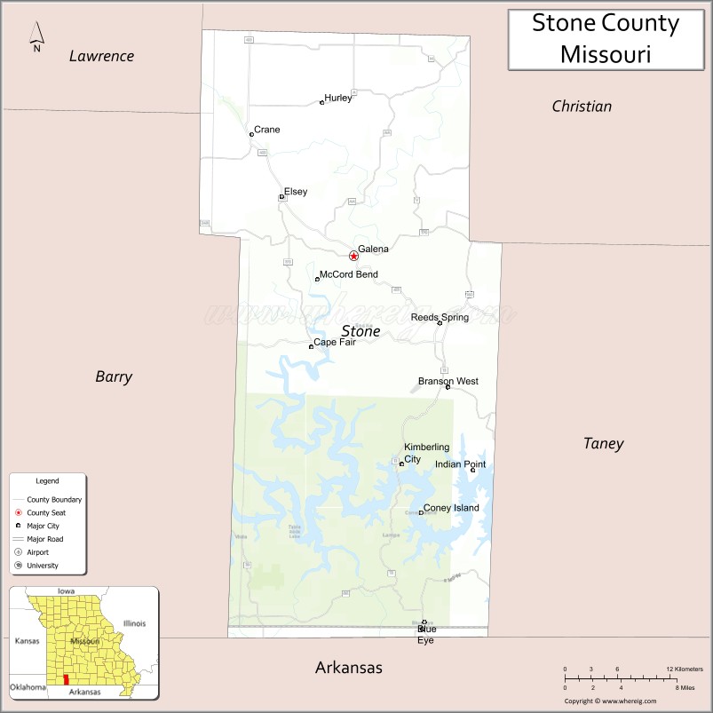
Map of Stone County, Missouri
About Stoddard County Map, Missouri: The map showing the county boundary, county seat, major cities, highways, water bodies and neighbouring counties.
Related Missouri Maps & Info
Stone County, Missouri
Stone County is a county located in the U.S. state of Missouri. It's county seat is Galena. As per 2020 census, the population of Stone County is 31548 people and population density is square miles. According to the United States Census Bureau, the county has a total area of 463 sq mi (1,199 km2). Stone County was established on 1851.
Stone County Facts
| Continent | North America |
| Country | United States |
| State | Missouri |
| County Seat | Galena |
| Largest City/Town | Kimberling City |
| Established | 1851 |
| Total Area | 511 sq mi (1,323 sq km) |
| Land Area | 464 sq mi (1,202 sq km) |
| Water Area | 47 sq mi (122 sq km) |
| Population | 31,076 (Census 2020) |
| Population Density | 67.0 people per sq mi |
| Time Zone | Central Time Zone (CST/CDT) |
| Major Highways | Missouri Route 13, Missouri Route 76, Missouri Route 248 |
| Major Rivers | White River, James River, Table Rock Lake |
| Neighboring Counties | Barry County, Christian County, Taney County, Lawrence County |
| Famous For | Table Rock Lake recreation, Ozark scenery, resorts, fishing, and boating |
| Top Attractions | Table Rock Lake, Silver Dollar City nearby region, Talking Rocks Cavern, and Dogwood Canyon Nature Park nearby region |
| Official Website | Official Website |
About Stone County
Stone County is located in southwestern Missouri within the Ozark Mountains and was established in 1851. The county seat is Galena, while Kimberling City is the largest community. The county is known for scenic lakes, outdoor recreation, tourism, fishing, boating, and beautiful Ozark landscapes.
Cities and Towns in Stone County, Missouri
| City/Town | Population (Census 2020) | Latitude & Longitude |
|---|---|---|
| Kimberling City | 2,253 | 36.6331°N, 93.4166°W |
| Galena (county seat) | 440 | 36.8056°N, 93.4655°W |
| Crane | 1,425 | 36.9056°N, 93.5710°W |
| Reeds Spring | 1,089 | 36.7473°N, 93.3771°W |
| Branson West | 478 | 36.6978°N, 93.3744°W |
| Indian Point nearby region | 612 | 36.6425°N, 93.3442°W |
What are the Golf Courses in Stone County
| Golf Course | Location | Latitude & Longitude |
|---|---|---|
| Ledgestone Country Club | Branson West | 36.6988°N, 93.3415°W |
| Kimberling Hills Golf Course | Kimberling City | 36.6407°N, 93.4283°W |
| LedgeStone Golf Resort | Stone County region | 36.7019°N, 93.3492°W |
Major Roads and Highways in Stone County
Major highways connect Stone County with Branson, Springfield, and the Ozark recreation region.
- Missouri Route 13 - major north-south transportation corridor through western Missouri
- Missouri Route 76 - scenic route connecting tourism and recreation destinations
- Missouri Route 248 - regional highway serving lake communities and resorts
What are Neighboring Counties of Stone County
- Christian County (north)
- Lawrence County (west)
- Barry County (southwest)
- Taney County (east)
What Are the Top Attractions in Stone County
The county offers scenic lakes, caves, nature parks, and extensive outdoor recreation opportunities.
- Table Rock Lake - boating, fishing, swimming, camping, and water sports
- Silver Dollar City nearby region - theme park, crafts, entertainment, and festivals
- Talking Rocks Cavern - cave tours and geological attractions
- Dogwood Canyon Nature Park nearby region - waterfalls, hiking, biking, and wildlife observation
- Ozark Mountain Scenic Drives - rolling hills and lake photography opportunities
- Fishing Resorts and Marinas - bass fishing and lake recreation activities
- Campgrounds and RV Parks - lakeside outdoor recreation and relaxation
- Community Festivals and Tourism Events - seasonal entertainment and cultural gatherings
- White River Recreation Areas - kayaking, canoeing, and nature observation
- Nature Trails and Conservation Areas - hiking and environmental exploration
What Is the Distance from Stone County to Nearby Cities
The following distances are measured by road (driving).
- Galena to Branson (Taney County), Missouri - 24 mi (39 km)
- Galena to Springfield (Greene County), Missouri - 43 mi (69 km)
- Galena to Harrison (Boone County), Arkansas - 48 mi (77 km)
- Galena to Fayetteville (Washington County), Arkansas - 95 mi (153 km)
- Galena to Kimberling City (Stone County), Missouri - 13 mi (21 km)
- Galena to Reeds Spring (Stone County), Missouri - 10 mi (16 km)
- Galena to Joplin (Jasper County), Missouri - 84 mi (135 km)
- Galena to Kansas City (Jackson County), Missouri - 217 mi (349 km)
- Galena to St. Louis (St. Louis City), Missouri - 253 mi (407 km)
- Galena to Tulsa (Tulsa County), Oklahoma - 174 mi (280 km)
- Galena to Dallas (Dallas County), Texas - 437 mi (703 km)
- Galena to Memphis (Shelby County), Tennessee - 364 mi (586 km)
- Galena to Denver (Denver County), Colorado - 736 mi (1,184 km)
FAQs about Stone County
Stone County is located in southwestern Missouri within the Ozark Mountains.
Stone County had a population of 31,076 according to the 2020 United States Census.
Stone County is known for Table Rock Lake recreation, fishing, boating, and scenic Ozark landscapes.
The county is served by Missouri Route 13, Missouri Route 76, and Missouri Route 248.
Yes, Stone County includes golf facilities such as Ledgestone Country Club and Kimberling Hills Golf Course.
References
- QuickFacts - U.S. Census Bureau
- United States Census Bureau
- United States Geological Survey (USGS)
- National Geodetic Survey
- Official Website
- Adair County Map
- Andrew County Map
- Atchison County Map
- Audrain County Map
- Barry County Map
- Barton County Map
- Bates County Map
- Benton County Map
- Bollinger County Map
- Boone County Map
- Buchanan County Map
- Butler County Map
- Caldwell County Map
- Callaway County Map
- Camden County Map
- Cape Girardeau County Map
- Carroll County Map
- Carter County Map
- Cass County Map
- Cedar County Map
- Chariton County Map
- Christian County Map
- Clark County Map
- Clay County Map
- Clinton County Map
- Cole County Map
- Cooper County Map
- Crawford County Map
- Dade County Map
- Dallas County Map
- Daviess County Map
- DeKalb County Map
- Dent County Map
- Douglas County Map
- Dunklin County Map
- Franklin County Map
- Gasconade County Map
- Gentry County Map
- Greene County Map
- Grundy County Map
- Harrison County Map
- Henry County Map
- Hickory County Map
- Holt County Map
- Howard County Map
- Howell County Map
- Iron County Map
- Jackson County Map
- Jasper County Map
- Jefferson County Map
- Johnson County Map
- Knox County Map
- Laclede County Map
- Lafayette County Map
- Lawrence County Map
- Lewis County Map
- Lincoln County Map
- Linn County Map
- Livingston County Map
- McDonald County Map
- Macon County Map
- Madison County Map
- Maries County Map
- Marion County Map
- Mercer County Map
- Miller County Map
- Mississippi County Map
- Moniteau County Map
- Monroe County Map
- Montgomery County Map
- Morgan County Map
- New Madrid County Map
- Newton County Map
- Nodaway County Map
- Oregon County Map
- Osage County Map
- Ozark County Map
- Pemiscot County Map
- Perry County Map
- Pettis County Map
- Phelps County Map
- Pike County Map
- Platte County Map
- Polk County Map
- Pulaski County Map
- Putnam County Map
- Ralls County Map
- Randolph County Map
- Ray County Map
- Reynolds County Map
- Ripley County Map
- St Charles County Map
- St Clair County Map
- Ste Genevieve County Map
- St Francois County Map
- St Louis County Map
- Saline County Map
- Schuyler County Map
- Scotland County Map
- Scott County Map
- Shannon County Map
- Shelby County Map
- Stoddard County Map
- Stone County Map
- Sullivan County Map
- Taney County Map
- Texas County Map
- Vernon County Map
- Warren County Map
- Washington County Map
- Wayne County Map
- Webster County Map
- Worth County Map
- Wright County Map
- St Louis County Map
- Alabama Counties
- Alaska boroughs
- Arizona Counties
- Arkansas Counties
- California County Map
- Colorado Counties
- Connecticut Counties
- Delaware Counties
- Florida County Map
- Georgia County Map
- Hawaii Counties
- Idaho Counties
- Illinois Counties
- Indiana Counties
- Iowa Counties
- Kansas Counties
- Kentucky Counties
- Louisiana Counties
- Maine Counties
- Maryland Counties
- Massachusetts Counties
- Michigan County Map
- Minnesota Counties
- Mississippi Counties
- Missouri Counties
- Montana Counties
- Nebraska Counties
- Nevada Counties
- New York Counties
- New Hampshire Counties
- New Jersey Counties
- New Mexico Counties
- North Carolina Counties
- North Dakota Counties
- Ohio County Map
- Oklahoma Counties
- Oregon Counties
- Pennsylvania Counties
- Rhode Island Counties
- South Carolina Counties
- South Dakota Counties
- Map of Tennessee
- Texas County Map
- Utah Counties
- Vermont Counties
- Virginia Counties
- Washington Counties
- West Virginia Counties
- Wisconsin Counties
- Wyoming Counties