Map of Jefferson County - Jefferson County is a county located in the U.S. state of Missouri. Jefferson County Map showing cities, highways, important places and water bodies. Get Where is Jefferson County located in the map, major cities in Jefferson county, population, areas, and places of interest.
Map of Jefferson County, Missouri
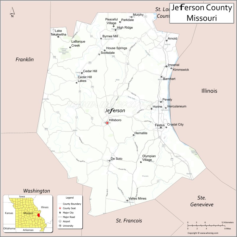
About Jefferson County Map, Missouri: The map showing the county boundary, county seat, major cities, highways, water bodies and neighbouring counties.
Related Missouri Maps & Info
Jefferson County, Missouri
Jefferson County is a county located in the U.S. state of Missouri. It's county seat is Hillsboro. As per 2020 census, the population of Jefferson County is 227771 people and population density is square miles. According to the United States Census Bureau, the county has a total area of 657 sq mi (1,702 km2). Jefferson County was established on 1818.
Jefferson County Facts
| Continent | North America |
| Country | United States |
| State | Missouri |
| County Seat | Hillsboro |
| Largest City/Town | Arnold |
| Established | 1818 |
| Total Area | 664 sq mi (1,720 sq km) |
| Land Area | 657 sq mi (1,702 sq km) |
| Water Area | 7 sq mi (18 sq km) |
| Population | 226,739 (Census 2020) |
| Population Density | 345.1 people per sq mi |
| Time Zone | Central Time Zone (CST/CDT) |
| Major Highways | Interstate 55, U.S. Route 61, U.S. Route 67, Missouri Route 21, Missouri Route 30 |
| Major Rivers | Mississippi River, Meramec River, Big River |
| Neighboring Counties | St. Louis County, St. Francois County, Franklin County, Washington County, Ste. Genevieve County |
| Famous For | St. Louis suburban communities, outdoor recreation, river valleys, and historic sites |
| Top Attractions | Mastodon State Historic Site, Sandy Creek Covered Bridge, Jefferson County parks, and Meramec River recreation |
| Official Website | Official Website |
About Jefferson County
Jefferson County is located in eastern Missouri south of St. Louis and was established in 1818. The county seat is Hillsboro, while Arnold is the largest city. The county is known for suburban communities, river recreation, historic landmarks, forests, and its blend of metropolitan access with scenic Ozark foothill landscapes.
Cities and Towns in Jefferson County, Missouri
| City/Town | Population (Census 2020) | Latitude & Longitude |
|---|---|---|
| Arnold | 20,858 | 38.4328°N, 90.3776°W |
| Festus | 12,610 | 38.2201°N, 90.3957°W |
| Crystal City | 4,247 | 38.2214°N, 90.3779°W |
| Hillsboro (county seat) | 3,283 | 38.2323°N, 90.5629°W |
| Pevely | 5,941 | 38.2834°N, 90.3948°W |
| De Soto | 6,400 | 38.1398°N, 90.5551°W |
What are the Golf Courses in Jefferson County
| Golf Course | Location | Latitude & Longitude |
|---|---|---|
| Crystal Highlands Golf Course | Festus | 38.2058°N, 90.4207°W |
| Oak Valley Golf Course | Pevely | 38.2946°N, 90.4035°W |
| Sunset Lakes Golf Course | Hillsboro | 38.2387°N, 90.5712°W |
Major Roads and Highways in Jefferson County
Major highways connect Jefferson County with St. Louis, southern Missouri, and Mississippi River communities.
- Interstate 55 - major north-south interstate linking St. Louis and Memphis
- U.S. Route 61 - important transportation corridor along the Mississippi River region
- U.S. Route 67 - major highway through eastern Missouri communities
- Missouri Route 21 - scenic route through forests and Ozark foothills
- Missouri Route 30 - regional highway connecting suburban communities
What are Neighboring Counties of Jefferson County
- St. Louis County (north)
- Franklin County (west)
- Washington County (southwest)
- St. Francois County (south)
- Ste. Genevieve County (southeast)
What Are the Top Attractions in Jefferson County
The county offers historic landmarks, river recreation, scenic parks, and outdoor attractions.
- Mastodon State Historic Site - Ice Age fossil exhibits, trails, and archaeology museum
- Sandy Creek Covered Bridge State Historic Site - historic wooden bridge and picnic area
- Jefferson County Parks and Recreation Areas - hiking, camping, and sports facilities
- Meramec River Recreation - canoeing, fishing, and kayaking opportunities
- Rockford Beach Park - swimming, boating, and family recreation
- Historic Main Streets in Festus and Crystal City - shopping and local dining
- Mark Twain National Forest nearby region - hiking and wildlife observation
- Mississippi River Scenic Areas - photography and nature viewing locations
- Local Vineyards and Wineries - wine tasting and countryside experiences
- Community Festivals and Heritage Events - seasonal celebrations and local culture
What Is the Distance from Jefferson County to Nearby Cities
The following distances are measured by road (driving).
- Hillsboro to St. Louis (St. Louis City), Missouri - 39 mi (63 km)
- Hillsboro to Farmington (St. Francois County), Missouri - 43 mi (69 km)
- Hillsboro to Cape Girardeau (Cape Girardeau County), Missouri - 108 mi (174 km)
- Hillsboro to Arnold (Jefferson County), Missouri - 19 mi (31 km)
- Hillsboro to Festus (Jefferson County), Missouri - 15 mi (24 km)
- Hillsboro to De Soto (Jefferson County), Missouri - 14 mi (23 km)
- Hillsboro to Springfield (Greene County), Missouri - 225 mi (362 km)
- Hillsboro to Columbia (Boone County), Missouri - 142 mi (229 km)
- Hillsboro to Kansas City (Jackson County), Missouri - 268 mi (431 km)
- Hillsboro to Memphis (Shelby County), Tennessee - 283 mi (455 km)
- Hillsboro to Chicago (Cook County), Illinois - 311 mi (500 km)
- Hillsboro to Nashville (Davidson County), Tennessee - 318 mi (512 km)
- Hillsboro to Denver (Denver County), Colorado - 854 mi (1,374 km)
FAQs about Jefferson County
Jefferson County is located in eastern Missouri south of St. Louis.
Jefferson County had a population of 226,739 according to the 2020 United States Census.
Jefferson County is known for suburban communities, river recreation, forests, and historic attractions.
The county is served by Interstate 55, U.S. Route 61, U.S. Route 67, Missouri Route 21, and Missouri Route 30.
Yes, Jefferson County includes golf facilities such as Crystal Highlands Golf Course, Oak Valley Golf Course, and Sunset Lakes Golf Course.
References
- QuickFacts - U.S. Census Bureau
- United States Census Bureau
- United States Geological Survey (USGS)
- National Geodetic Survey
- Official Website
- Adair County Map
- Andrew County Map
- Atchison County Map
- Audrain County Map
- Barry County Map
- Barton County Map
- Bates County Map
- Benton County Map
- Bollinger County Map
- Boone County Map
- Buchanan County Map
- Butler County Map
- Caldwell County Map
- Callaway County Map
- Camden County Map
- Cape Girardeau County Map
- Carroll County Map
- Carter County Map
- Cass County Map
- Cedar County Map
- Chariton County Map
- Christian County Map
- Clark County Map
- Clay County Map
- Clinton County Map
- Cole County Map
- Cooper County Map
- Crawford County Map
- Dade County Map
- Dallas County Map
- Daviess County Map
- DeKalb County Map
- Dent County Map
- Douglas County Map
- Dunklin County Map
- Franklin County Map
- Gasconade County Map
- Gentry County Map
- Greene County Map
- Grundy County Map
- Harrison County Map
- Henry County Map
- Hickory County Map
- Holt County Map
- Howard County Map
- Howell County Map
- Iron County Map
- Jackson County Map
- Jasper County Map
- Jefferson County Map
- Johnson County Map
- Knox County Map
- Laclede County Map
- Lafayette County Map
- Lawrence County Map
- Lewis County Map
- Lincoln County Map
- Linn County Map
- Livingston County Map
- McDonald County Map
- Macon County Map
- Madison County Map
- Maries County Map
- Marion County Map
- Mercer County Map
- Miller County Map
- Mississippi County Map
- Moniteau County Map
- Monroe County Map
- Montgomery County Map
- Morgan County Map
- New Madrid County Map
- Newton County Map
- Nodaway County Map
- Oregon County Map
- Osage County Map
- Ozark County Map
- Pemiscot County Map
- Perry County Map
- Pettis County Map
- Phelps County Map
- Pike County Map
- Platte County Map
- Polk County Map
- Pulaski County Map
- Putnam County Map
- Ralls County Map
- Randolph County Map
- Ray County Map
- Reynolds County Map
- Ripley County Map
- St Charles County Map
- St Clair County Map
- Ste Genevieve County Map
- St Francois County Map
- St Louis County Map
- Saline County Map
- Schuyler County Map
- Scotland County Map
- Scott County Map
- Shannon County Map
- Shelby County Map
- Stoddard County Map
- Stone County Map
- Sullivan County Map
- Taney County Map
- Texas County Map
- Vernon County Map
- Warren County Map
- Washington County Map
- Wayne County Map
- Webster County Map
- Worth County Map
- Wright County Map
- St Louis County Map
- Alabama Counties
- Alaska boroughs
- Arizona Counties
- Arkansas Counties
- California County Map
- Colorado Counties
- Connecticut Counties
- Delaware Counties
- Florida County Map
- Georgia County Map
- Hawaii Counties
- Idaho Counties
- Illinois Counties
- Indiana Counties
- Iowa Counties
- Kansas Counties
- Kentucky Counties
- Louisiana Counties
- Maine Counties
- Maryland Counties
- Massachusetts Counties
- Michigan County Map
- Minnesota Counties
- Mississippi Counties
- Missouri Counties
- Montana Counties
- Nebraska Counties
- Nevada Counties
- New York Counties
- New Hampshire Counties
- New Jersey Counties
- New Mexico Counties
- North Carolina Counties
- North Dakota Counties
- Ohio County Map
- Oklahoma Counties
- Oregon Counties
- Pennsylvania Counties
- Rhode Island Counties
- South Carolina Counties
- South Dakota Counties
- Map of Tennessee
- Texas County Map
- Utah Counties
- Vermont Counties
- Virginia Counties
- Washington Counties
- West Virginia Counties
- Wisconsin Counties
- Wyoming Counties