Map of Cass County - Cass County is a county located in the U.S. state of Missouri. Cass County Map showing cities, highways, important places and water bodies. Get Where is Cass County located in the map, major cities in Cass county, population, areas, and places of interest.
Map of Cass County, Missouri
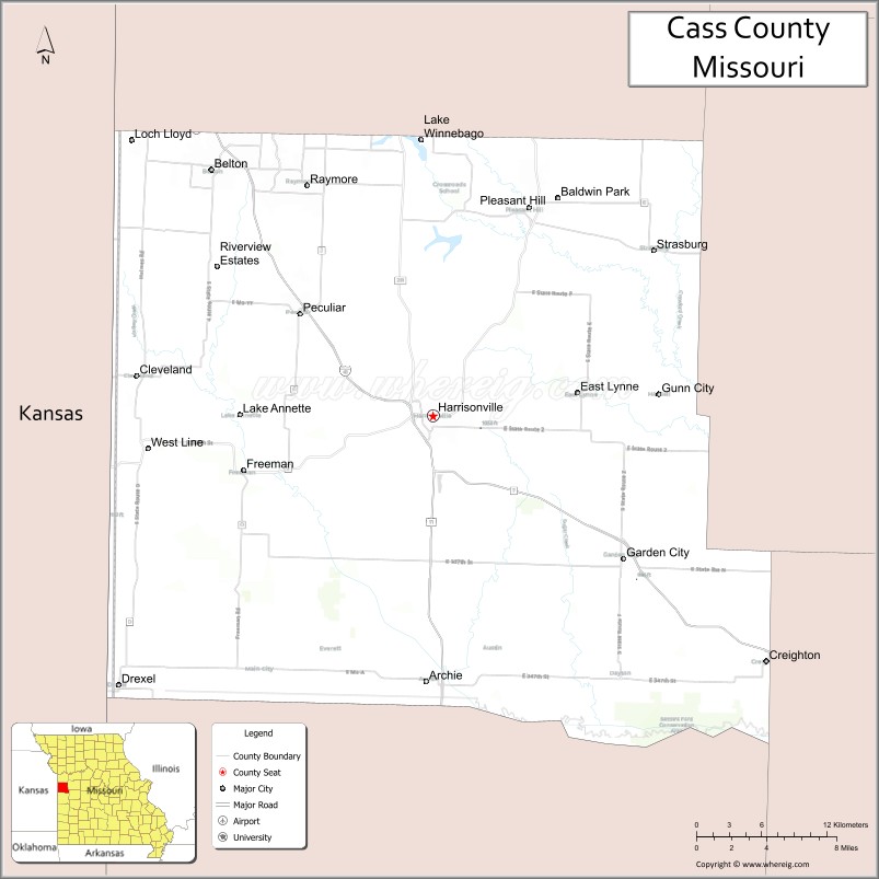
About Cass County Map, Missouri: The map showing the county boundary, county seat, major cities, highways, water bodies and neighbouring counties.
Related Missouri Maps & Info
Cass County, Missouri
Cass County is a county located in the U.S. state of Missouri. It's county seat is Harrisonville. As per 2020 census, the population of Cass County is 109638 people and population density is square miles. According to the United States Census Bureau, the county has a total area of 699 sq mi (1,810 km2). Cass County was established on 1833.
Cass County Facts
| Continent | North America |
| Country | United States |
| State | Missouri |
| County Seat | Harrisonville |
| Largest City/Town | Belton |
| Established | 1835 |
| Total Area | 702 sq mi (1,818 sq km) |
| Land Area | 697 sq mi (1,805 sq km) |
| Water Area | 5 sq mi (13 sq km) |
| Population | 107,824 (Census 2020) |
| Population Density | 154.7 people per sq mi |
| Time Zone | Central Time Zone (CST/CDT) |
| Major Highways | Interstate 49, U.S. Route 71, Missouri Route 7, Missouri Route 58 |
| Major Rivers | South Grand River, Big Creek, Missouri River nearby region |
| Neighboring Counties | Jackson County, Johnson County, Bates County, Henry County, Miami County (Kansas) |
| Famous For | Kansas City suburban communities, Civil War history, parks, and outdoor recreation |
| Top Attractions | Powell Gardens nearby region, Harrisonville historic square, Belton Grandview and Kansas City Railroad, and Peculiar parks |
| Official Website | Official Website |
About Cass County
Cass County is located in western Missouri in the Kansas City metropolitan region and was established in 1835. The county seat is Harrisonville, while Belton is the largest city. The county is known for suburban growth, historical sites, outdoor recreation, and its blend of rural landscapes and metropolitan development.
Cities and Towns in Cass County, Missouri
| City/Town | Population (Census 2020) | Latitude & Longitude |
|---|---|---|
| Belton | 23,116 | 38.8119°N, 94.5319°W |
| Harrisonville (county seat) | 10,019 | 38.6533°N, 94.3486°W |
| Raymore | 22,941 | 38.8017°N, 94.4527°W |
| Peculiar | 5,621 | 38.7192°N, 94.4586°W |
| Pleasant Hill | 8,777 | 38.7875°N, 94.2697°W |
| Garden City | 1,450 | 38.5614°N, 94.1924°W |
What are the Golf Courses in Cass County
| Golf Course | Location | Latitude & Longitude |
|---|---|---|
| Harrisonville Country Club | Harrisonville | 38.6627°N, 94.3561°W |
| Creekmoor Golf Club | Raymore | 38.7714°N, 94.4328°W |
| Eagle Glen Golf Club | Raymore | 38.8069°N, 94.4621°W |
Major Roads and Highways in Cass County
Major highways connect the county with Kansas City and regional transportation corridors across western Missouri.
- Interstate 49 - major north-south interstate through western Missouri
- U.S. Route 71 - important transportation corridor linking Kansas City and Arkansas
- Missouri Route 7 - regional highway connecting suburban and rural communities
- Missouri Route 58 - east-west route serving growing metropolitan areas
What are Neighboring Counties of Cass County
- Jackson County (north)
- Johnson County (east)
- Henry County (southeast)
- Bates County (south)
- Miami County, Kansas (west)
What Are the Top Attractions in Cass County
The county offers a mix of suburban attractions, parks, rail history, and outdoor recreation.
- Powell Gardens nearby region - botanical gardens, walking trails, and seasonal events
- Harrisonville Historic Square - shops, restaurants, and preserved courthouse district
- Belton Grandview and Kansas City Railroad - scenic train rides and railroad history
- Peculiar Parks and Recreation Areas - sports fields, trails, and community events
- Raymore Recreation Park - playgrounds, lakes, and outdoor activities
- Pleasant Hill Historic District - historic homes and local cultural attractions
- South Grand River Recreation Areas - fishing and nature observation opportunities
- Cass County Museum - exhibits on pioneer settlement and Civil War history
- Metropolitan Kansas City Scenic Drives - suburban and countryside landscapes
- Community Festivals and Fairs - seasonal celebrations, rodeos, and family events
What Is the Distance from Cass County to Nearby Cities
The following distances are measured by road (driving).
- Harrisonville to Kansas City (Jackson County), Missouri - 38 mi (61 km)
- Harrisonville to Independence (Jackson County), Missouri - 43 mi (69 km)
- Harrisonville to Sedalia (Pettis County), Missouri - 74 mi (119 km)
- Harrisonville to Butler (Bates County), Missouri - 31 mi (50 km)
- Harrisonville to Belton (Cass County), Missouri - 16 mi (26 km)
- Harrisonville to Raymore (Cass County), Missouri - 14 mi (23 km)
- Harrisonville to Columbia (Boone County), Missouri - 148 mi (238 km)
- Harrisonville to Wichita (Sedgwick County), Kansas - 192 mi (309 km)
- Harrisonville to Saint Louis (St. Louis City), Missouri - 256 mi (412 km)
- Harrisonville to Omaha (Douglas County), Nebraska - 213 mi (343 km)
- Harrisonville to Tulsa (Tulsa County), Oklahoma - 221 mi (356 km)
- Harrisonville to Denver (Denver County), Colorado - 608 mi (978 km)
- Harrisonville to Chicago (Cook County), Illinois - 523 mi (842 km)
FAQs about Cass County
Cass County is located in western Missouri within the Kansas City metropolitan region.
Cass County had a population of 107,824 according to the 2020 United States Census.
Cass County is known for Kansas City suburban communities, parks, Civil War history, and outdoor recreation.
The county is served by Interstate 49, U.S. Route 71, Missouri Route 7, and Missouri Route 58.
Yes, Cass County includes golf facilities such as Harrisonville Country Club, Creekmoor Golf Club, and Eagle Glen Golf Club.
References
- QuickFacts - U.S. Census Bureau
- United States Census Bureau
- United States Geological Survey (USGS)
- National Geodetic Survey
- Official Website
- Adair County Map
- Andrew County Map
- Atchison County Map
- Audrain County Map
- Barry County Map
- Barton County Map
- Bates County Map
- Benton County Map
- Bollinger County Map
- Boone County Map
- Buchanan County Map
- Butler County Map
- Caldwell County Map
- Callaway County Map
- Camden County Map
- Cape Girardeau County Map
- Carroll County Map
- Carter County Map
- Cass County Map
- Cedar County Map
- Chariton County Map
- Christian County Map
- Clark County Map
- Clay County Map
- Clinton County Map
- Cole County Map
- Cooper County Map
- Crawford County Map
- Dade County Map
- Dallas County Map
- Daviess County Map
- DeKalb County Map
- Dent County Map
- Douglas County Map
- Dunklin County Map
- Franklin County Map
- Gasconade County Map
- Gentry County Map
- Greene County Map
- Grundy County Map
- Harrison County Map
- Henry County Map
- Hickory County Map
- Holt County Map
- Howard County Map
- Howell County Map
- Iron County Map
- Jackson County Map
- Jasper County Map
- Jefferson County Map
- Johnson County Map
- Knox County Map
- Laclede County Map
- Lafayette County Map
- Lawrence County Map
- Lewis County Map
- Lincoln County Map
- Linn County Map
- Livingston County Map
- McDonald County Map
- Macon County Map
- Madison County Map
- Maries County Map
- Marion County Map
- Mercer County Map
- Miller County Map
- Mississippi County Map
- Moniteau County Map
- Monroe County Map
- Montgomery County Map
- Morgan County Map
- New Madrid County Map
- Newton County Map
- Nodaway County Map
- Oregon County Map
- Osage County Map
- Ozark County Map
- Pemiscot County Map
- Perry County Map
- Pettis County Map
- Phelps County Map
- Pike County Map
- Platte County Map
- Polk County Map
- Pulaski County Map
- Putnam County Map
- Ralls County Map
- Randolph County Map
- Ray County Map
- Reynolds County Map
- Ripley County Map
- St Charles County Map
- St Clair County Map
- Ste Genevieve County Map
- St Francois County Map
- St Louis County Map
- Saline County Map
- Schuyler County Map
- Scotland County Map
- Scott County Map
- Shannon County Map
- Shelby County Map
- Stoddard County Map
- Stone County Map
- Sullivan County Map
- Taney County Map
- Texas County Map
- Vernon County Map
- Warren County Map
- Washington County Map
- Wayne County Map
- Webster County Map
- Worth County Map
- Wright County Map
- St Louis County Map
- Alabama Counties
- Alaska boroughs
- Arizona Counties
- Arkansas Counties
- California County Map
- Colorado Counties
- Connecticut Counties
- Delaware Counties
- Florida County Map
- Georgia County Map
- Hawaii Counties
- Idaho Counties
- Illinois Counties
- Indiana Counties
- Iowa Counties
- Kansas Counties
- Kentucky Counties
- Louisiana Counties
- Maine Counties
- Maryland Counties
- Massachusetts Counties
- Michigan County Map
- Minnesota Counties
- Mississippi Counties
- Missouri Counties
- Montana Counties
- Nebraska Counties
- Nevada Counties
- New York Counties
- New Hampshire Counties
- New Jersey Counties
- New Mexico Counties
- North Carolina Counties
- North Dakota Counties
- Ohio County Map
- Oklahoma Counties
- Oregon Counties
- Pennsylvania Counties
- Rhode Island Counties
- South Carolina Counties
- South Dakota Counties
- Map of Tennessee
- Texas County Map
- Utah Counties
- Vermont Counties
- Virginia Counties
- Washington Counties
- West Virginia Counties
- Wisconsin Counties
- Wyoming Counties