Map of Perry County - Perry County is a county located in the U.S. state of Missouri. Perry County Map showing cities, highways, important places and water bodies. Get Where is Perry County located in the map, major cities in Perry county, population, areas, and places of interest.
Map of Perry County, Missouri
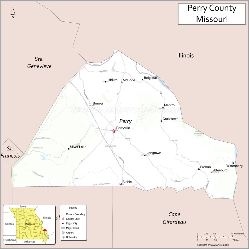
About Perry County Map, Missouri: The map showing the county boundary, county seat, major cities, highways, water bodies and neighbouring counties.
Related Missouri Maps & Info
Perry County, Missouri
Perry County is a county located in the U.S. state of Missouri. It's county seat is Perryville. As per 2020 census, the population of Perry County is 18922 people and population density is square miles. According to the United States Census Bureau, the county has a total area of 475 sq mi (1,230 km2). Perry County was established on 1821.
Perry County Facts
| Continent | North America |
| Country | United States |
| State | Missouri |
| County Seat | Perryville |
| Largest City/Town | Perryville |
| Established | 1821 |
| Total Area | 484 sq mi (1,254 sq km) |
| Land Area | 474 sq mi (1,228 sq km) |
| Water Area | 10 sq mi (26 sq km) |
| Population | 18,956 (Census 2020) |
| Population Density | 40.0 people per sq mi |
| Time Zone | Central Time Zone (CST/CDT) |
| Major Highways | Interstate 55, U.S. Route 61 nearby region, Missouri Route 51, Missouri Route 72 |
| Major Rivers | Mississippi River nearby region, Apple Creek |
| Neighboring Counties | Ste. Genevieve County, Cape Girardeau County, Bollinger County, St. Francois County, Randolph County (Illinois) |
| Famous For | German heritage, historic churches, scenic countryside, and Perryville battlefield history |
| Top Attractions | National Shrine of Our Lady of the Miraculous Medal, Perry County Courthouse, Perryville Battlefield State Historic Site, and historic downtown Perryville |
| Official Website | Official Website |
About Perry County
Perry County is located in southeastern Missouri between St. Louis and Cape Girardeau and was established in 1821. The county seat and largest city is Perryville. The county is known for German-American heritage, rolling hills, historic churches, Civil War history, and scenic rural landscapes.
Cities and Towns in Perry County, Missouri
| City/Town | Population (Census 2020) | Latitude & Longitude |
|---|---|---|
| Perryville (county seat) | 8,458 | 37.7242°N, 89.8612°W |
| Altenburg | 352 | 37.6378°N, 89.5856°W |
| Frohna | 254 | 37.6345°N, 89.6204°W |
| Biehle | 38 | 37.6289°N, 89.8506°W |
| Longtown nearby area | 102 | 37.7077°N, 89.8175°W |
| Uniontown | 505 | 37.6517°N, 89.6998°W |
What are the Golf Courses in Perry County
| Golf Course | Location | Latitude & Longitude |
|---|---|---|
| Perryville Country Club | Perryville | 37.7358°N, 89.8745°W |
| Apple Creek Golf Club | Perryville nearby region | 37.7123°N, 89.8471°W |
| Historic Hills Recreation Golf Area | Altenburg nearby region | 37.6469°N, 89.5951°W |
Major Roads and Highways in Perry County
Major highways connect Perry County with St. Louis, Cape Girardeau, and southeastern Missouri communities.
- Interstate 55 - major north-south interstate corridor through eastern Missouri
- U.S. Route 61 nearby region - historic highway paralleling the Mississippi River
- Missouri Route 51 - regional route serving river communities and rural areas
- Missouri Route 72 - east-west transportation route through the Ozark foothills
What are Neighboring Counties of Perry County
- Ste. Genevieve County (north)
- Randolph County, Illinois (east)
- Cape Girardeau County (south)
- Bollinger County (west)
- St. Francois County (northwest)
What Are the Top Attractions in Perry County
The county offers historic sites, scenic countryside, cultural heritage attractions, and outdoor recreation.
- National Shrine of Our Lady of the Miraculous Medal - historic religious landmark and pilgrimage destination
- Perryville Battlefield State Historic Site - Civil War battlefield and interpretive exhibits
- Historic Downtown Perryville - shops, restaurants, and preserved architecture
- German Heritage Communities - traditional churches, festivals, and cultural history
- Apple Creek Recreation Areas - fishing, hiking, and outdoor family activities
- Mississippi River Scenic Nearby Region - river views and photography locations
- Perry County Courthouse - historic landmark and architectural attraction
- Community Festivals and Heritage Events - seasonal celebrations and local traditions
- Rolling Hills Scenic Drives - countryside landscapes and photography opportunities
- Wildlife and Conservation Areas - birdwatching, hiking, and nature exploration
What Is the Distance from Perry County to Nearby Cities
The following distances are measured by road (driving).
- Perryville to Cape Girardeau (Cape Girardeau County), Missouri - 51 mi (82 km)
- Perryville to St. Louis (St. Louis City), Missouri - 79 mi (127 km)
- Perryville to Farmington (St. Francois County), Missouri - 49 mi (79 km)
- Perryville to Jackson (Cape Girardeau County), Missouri - 41 mi (66 km)
- Perryville to Altenburg (Perry County), Missouri - 23 mi (37 km)
- Perryville to Frohna (Perry County), Missouri - 21 mi (34 km)
- Perryville to Springfield (Greene County), Missouri - 236 mi (380 km)
- Perryville to Kansas City (Jackson County), Missouri - 285 mi (459 km)
- Perryville to Memphis (Shelby County), Tennessee - 236 mi (380 km)
- Perryville to Nashville (Davidson County), Tennessee - 293 mi (472 km)
- Perryville to Chicago (Cook County), Illinois - 337 mi (542 km)
- Perryville to Dallas (Dallas County), Texas - 596 mi (959 km)
- Perryville to Denver (Denver County), Colorado - 857 mi (1,379 km)
FAQs about Perry County
Perry County is located in southeastern Missouri between St. Louis and Cape Girardeau.
Perry County had a population of 18,956 according to the 2020 United States Census.
Perry County is known for German heritage, historic churches, Civil War history, and scenic countryside.
The county is served by Interstate 55, nearby U.S. Route 61, Missouri Route 51, and Missouri Route 72.
Yes, Perry County includes golf facilities such as Perryville Country Club and Apple Creek Golf Club.
References
- QuickFacts - U.S. Census Bureau
- United States Census Bureau
- United States Geological Survey (USGS)
- National Geodetic Survey
- Official Website
- Adair County Map
- Andrew County Map
- Atchison County Map
- Audrain County Map
- Barry County Map
- Barton County Map
- Bates County Map
- Benton County Map
- Bollinger County Map
- Boone County Map
- Buchanan County Map
- Butler County Map
- Caldwell County Map
- Callaway County Map
- Camden County Map
- Cape Girardeau County Map
- Carroll County Map
- Carter County Map
- Cass County Map
- Cedar County Map
- Chariton County Map
- Christian County Map
- Clark County Map
- Clay County Map
- Clinton County Map
- Cole County Map
- Cooper County Map
- Crawford County Map
- Dade County Map
- Dallas County Map
- Daviess County Map
- DeKalb County Map
- Dent County Map
- Douglas County Map
- Dunklin County Map
- Franklin County Map
- Gasconade County Map
- Gentry County Map
- Greene County Map
- Grundy County Map
- Harrison County Map
- Henry County Map
- Hickory County Map
- Holt County Map
- Howard County Map
- Howell County Map
- Iron County Map
- Jackson County Map
- Jasper County Map
- Jefferson County Map
- Johnson County Map
- Knox County Map
- Laclede County Map
- Lafayette County Map
- Lawrence County Map
- Lewis County Map
- Lincoln County Map
- Linn County Map
- Livingston County Map
- McDonald County Map
- Macon County Map
- Madison County Map
- Maries County Map
- Marion County Map
- Mercer County Map
- Miller County Map
- Mississippi County Map
- Moniteau County Map
- Monroe County Map
- Montgomery County Map
- Morgan County Map
- New Madrid County Map
- Newton County Map
- Nodaway County Map
- Oregon County Map
- Osage County Map
- Ozark County Map
- Pemiscot County Map
- Perry County Map
- Pettis County Map
- Phelps County Map
- Pike County Map
- Platte County Map
- Polk County Map
- Pulaski County Map
- Putnam County Map
- Ralls County Map
- Randolph County Map
- Ray County Map
- Reynolds County Map
- Ripley County Map
- St Charles County Map
- St Clair County Map
- Ste Genevieve County Map
- St Francois County Map
- St Louis County Map
- Saline County Map
- Schuyler County Map
- Scotland County Map
- Scott County Map
- Shannon County Map
- Shelby County Map
- Stoddard County Map
- Stone County Map
- Sullivan County Map
- Taney County Map
- Texas County Map
- Vernon County Map
- Warren County Map
- Washington County Map
- Wayne County Map
- Webster County Map
- Worth County Map
- Wright County Map
- St Louis County Map
- Alabama Counties
- Alaska boroughs
- Arizona Counties
- Arkansas Counties
- California County Map
- Colorado Counties
- Connecticut Counties
- Delaware Counties
- Florida County Map
- Georgia County Map
- Hawaii Counties
- Idaho Counties
- Illinois Counties
- Indiana Counties
- Iowa Counties
- Kansas Counties
- Kentucky Counties
- Louisiana Counties
- Maine Counties
- Maryland Counties
- Massachusetts Counties
- Michigan County Map
- Minnesota Counties
- Mississippi Counties
- Missouri Counties
- Montana Counties
- Nebraska Counties
- Nevada Counties
- New York Counties
- New Hampshire Counties
- New Jersey Counties
- New Mexico Counties
- North Carolina Counties
- North Dakota Counties
- Ohio County Map
- Oklahoma Counties
- Oregon Counties
- Pennsylvania Counties
- Rhode Island Counties
- South Carolina Counties
- South Dakota Counties
- Map of Tennessee
- Texas County Map
- Utah Counties
- Vermont Counties
- Virginia Counties
- Washington Counties
- West Virginia Counties
- Wisconsin Counties
- Wyoming Counties