Map of Jackson County - Jackson County is a county located in the U.S. state of Missouri. Jackson County Map showing cities, highways, important places and water bodies. Get Where is Jackson County located in the map, major cities in Jackson county, population, areas, and places of interest.
Map of Jackson County, Missouri
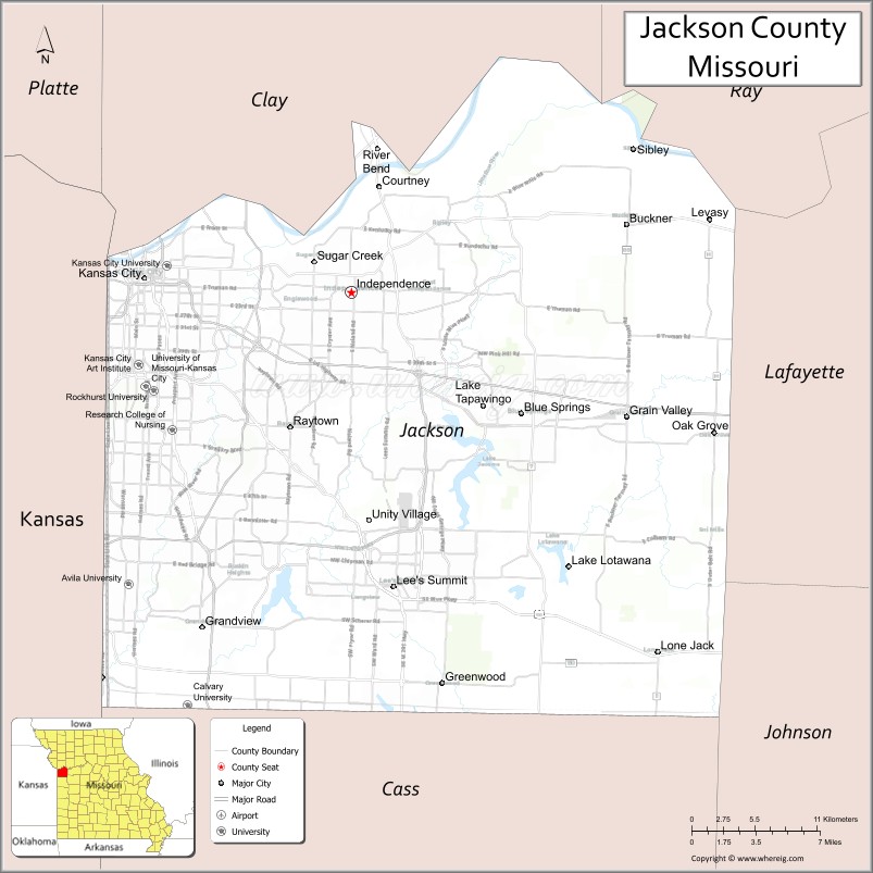
About Jackson County Map, Missouri: The map showing the county boundary, county seat, major cities, highways, water bodies and neighbouring counties.
Related Missouri Maps & Info
Jackson County, Missouri
"Jackson County is a county located in the U.S. state of Missouri. It's county seat is Independence, Kansas City. As per 2020 census, the population of Jackson County is 716862 people and population density is square miles. According to the United States Census Bureau, the county has a total area of 605 sq mi (1,567 km2). Jackson County was established on 1826."
Jackson County Facts
| Continent | North America |
| Country | United States |
| State | Missouri |
| County Seat | Kansas City and Independence |
| Largest City/Town | Kansas City |
| Established | 1826 |
| Total Area | 616 sq mi (1,595 sq km) |
| Land Area | 604 sq mi (1,564 sq km) |
| Water Area | 12 sq mi (31 sq km) |
| Population | 717,204 (Census 2020) |
| Population Density | 1,187.4 people per sq mi |
| Time Zone | Central Time Zone (CST/CDT) |
| Major Highways | Interstate 70, Interstate 435, Interstate 470, Interstate 49, U.S. Route 40, U.S. Route 71, U.S. Route 24 |
| Major Rivers | Missouri River, Blue River |
| Neighboring Counties | Clay County, Lafayette County, Johnson County (Missouri), Cass County, Platte County, Wyandotte County (Kansas), Johnson County (Kansas) |
| Famous For | Kansas City, jazz heritage, barbecue cuisine, professional sports, and historical landmarks |
| Top Attractions | National WWI Museum and Memorial, Arrowhead Stadium, Kauffman Stadium, Country Club Plaza, and Union Station |
| Official Website | Official Website |
About Jackson County
Jackson County is located in western Missouri along the Missouri River and was established in 1826. The county includes Kansas City, Independence, and several major suburban communities. It is known for jazz music, barbecue culture, professional sports, transportation history, entertainment districts, and being one of the most populous counties in Missouri.
Cities and Towns in Jackson County, Missouri
| City/Town | Population (Census 2020) | Latitude & Longitude |
|---|---|---|
| Kansas City | 508,090 | 39.0997°N, 94.5786°W |
| Independence | 123,011 | 39.0911°N, 94.4155°W |
| Lee’s Summit | 101,108 | 38.9108°N, 94.3822°W |
| Blue Springs | 58,604 | 39.0169°N, 94.2816°W |
| Grandview | 26,209 | 38.8858°N, 94.5330°W |
| Raytown | 30,012 | 39.0086°N, 94.4636°W |
What are the Golf Courses in Jackson County
| Golf Course | Location | Latitude & Longitude |
|---|---|---|
| Swope Memorial Golf Course | Kansas City | 39.0062°N, 94.5294°W |
| Fred Arbanas Golf Course | Kansas City | 38.9841°N, 94.4363°W |
| Lakewood Oaks Country Club | Lee’s Summit | 38.9442°N, 94.3369°W |
Major Roads and Highways in Jackson County
Jackson County contains one of the largest highway systems in Missouri and serves as a major transportation hub in the Midwest.
- Interstate 70 - major east-west interstate connecting Kansas City and St. Louis
- Interstate 435 - beltway surrounding the Kansas City metropolitan area
- Interstate 470 - southeastern bypass route through suburban communities
- Interstate 49 - north-south transportation corridor connecting Missouri and Arkansas
- U.S. Route 40 - historic highway through Kansas City and Independence
- U.S. Route 71 - important regional transportation route
- U.S. Route 24 - connector route through northern Jackson County
What are Neighboring Counties of Jackson County
- Clay County (north)
- Platte County (northwest)
- Lafayette County (east)
- Johnson County, Missouri (southeast)
- Cass County (south)
- Wyandotte County, Kansas (west)
- Johnson County, Kansas (southwest)
What Are the Top Attractions in Jackson County
The county offers major museums, sports venues, entertainment districts, and historic attractions.
- National WWI Museum and Memorial - nationally recognized military history museum and monument
- Arrowhead Stadium - home of the Kansas City Chiefs football team
- Kauffman Stadium - home of the Kansas City Royals baseball team
- Country Club Plaza - historic shopping and entertainment district
- Union Station Kansas City - restored historic train station with museums and exhibits
- Nelson-Atkins Museum of Art - major art museum with international collections
- 18th and Vine Historic Jazz District - jazz history museums and live music venues
- Harry S. Truman Presidential Library and Museum - exhibits about President Truman and U.S. history
- Worlds of Fun and Oceans of Fun - amusement and water park attractions
- Kansas City Zoo and Aquarium - wildlife exhibits and family entertainment
What Is the Distance from Jackson County to Nearby Cities
The following distances are measured by road (driving).
- Kansas City to St. Joseph (Buchanan County), Missouri - 55 mi (89 km)
- Kansas City to Columbia (Boone County), Missouri - 126 mi (203 km)
- Kansas City to Jefferson City (Cole County), Missouri - 159 mi (256 km)
- Kansas City to Springfield (Greene County), Missouri - 166 mi (267 km)
- Kansas City to Lee’s Summit (Jackson County), Missouri - 19 mi (31 km)
- Kansas City to Independence (Jackson County), Missouri - 10 mi (16 km)
- Kansas City to Wichita (Sedgwick County), Kansas - 197 mi (317 km)
- Kansas City to Omaha (Douglas County), Nebraska - 187 mi (301 km)
- Kansas City to St. Louis (St. Louis City), Missouri - 248 mi (399 km)
- Kansas City to Chicago (Cook County), Illinois - 511 mi (822 km)
- Kansas City to Denver (Denver County), Colorado - 604 mi (972 km)
- Kansas City to Dallas (Dallas County), Texas - 510 mi (821 km)
- Kansas City to Minneapolis (Hennepin County), Minnesota - 438 mi (705 km)
FAQs about Jackson County
Jackson County is located in western Missouri along the Missouri River.
Jackson County had a population of 717,204 according to the 2020 United States Census.
Jackson County is known for Kansas City, jazz music, barbecue cuisine, professional sports, and historic attractions.
The county is served by Interstate 70, Interstate 435, Interstate 470, Interstate 49, U.S. Route 40, U.S. Route 71, and U.S. Route 24.
Yes, Jackson County includes golf facilities such as Swope Memorial Golf Course, Fred Arbanas Golf Course, and Lakewood Oaks Country Club.
References
- QuickFacts - U.S. Census Bureau
- United States Census Bureau
- United States Geological Survey (USGS)
- National Geodetic Survey
- Official Website
- Adair County Map
- Andrew County Map
- Atchison County Map
- Audrain County Map
- Barry County Map
- Barton County Map
- Bates County Map
- Benton County Map
- Bollinger County Map
- Boone County Map
- Buchanan County Map
- Butler County Map
- Caldwell County Map
- Callaway County Map
- Camden County Map
- Cape Girardeau County Map
- Carroll County Map
- Carter County Map
- Cass County Map
- Cedar County Map
- Chariton County Map
- Christian County Map
- Clark County Map
- Clay County Map
- Clinton County Map
- Cole County Map
- Cooper County Map
- Crawford County Map
- Dade County Map
- Dallas County Map
- Daviess County Map
- DeKalb County Map
- Dent County Map
- Douglas County Map
- Dunklin County Map
- Franklin County Map
- Gasconade County Map
- Gentry County Map
- Greene County Map
- Grundy County Map
- Harrison County Map
- Henry County Map
- Hickory County Map
- Holt County Map
- Howard County Map
- Howell County Map
- Iron County Map
- Jackson County Map
- Jasper County Map
- Jefferson County Map
- Johnson County Map
- Knox County Map
- Laclede County Map
- Lafayette County Map
- Lawrence County Map
- Lewis County Map
- Lincoln County Map
- Linn County Map
- Livingston County Map
- McDonald County Map
- Macon County Map
- Madison County Map
- Maries County Map
- Marion County Map
- Mercer County Map
- Miller County Map
- Mississippi County Map
- Moniteau County Map
- Monroe County Map
- Montgomery County Map
- Morgan County Map
- New Madrid County Map
- Newton County Map
- Nodaway County Map
- Oregon County Map
- Osage County Map
- Ozark County Map
- Pemiscot County Map
- Perry County Map
- Pettis County Map
- Phelps County Map
- Pike County Map
- Platte County Map
- Polk County Map
- Pulaski County Map
- Putnam County Map
- Ralls County Map
- Randolph County Map
- Ray County Map
- Reynolds County Map
- Ripley County Map
- St Charles County Map
- St Clair County Map
- Ste Genevieve County Map
- St Francois County Map
- St Louis County Map
- Saline County Map
- Schuyler County Map
- Scotland County Map
- Scott County Map
- Shannon County Map
- Shelby County Map
- Stoddard County Map
- Stone County Map
- Sullivan County Map
- Taney County Map
- Texas County Map
- Vernon County Map
- Warren County Map
- Washington County Map
- Wayne County Map
- Webster County Map
- Worth County Map
- Wright County Map
- St Louis County Map
- Alabama Counties
- Alaska boroughs
- Arizona Counties
- Arkansas Counties
- California County Map
- Colorado Counties
- Connecticut Counties
- Delaware Counties
- Florida County Map
- Georgia County Map
- Hawaii Counties
- Idaho Counties
- Illinois Counties
- Indiana Counties
- Iowa Counties
- Kansas Counties
- Kentucky Counties
- Louisiana Counties
- Maine Counties
- Maryland Counties
- Massachusetts Counties
- Michigan County Map
- Minnesota Counties
- Mississippi Counties
- Missouri Counties
- Montana Counties
- Nebraska Counties
- Nevada Counties
- New York Counties
- New Hampshire Counties
- New Jersey Counties
- New Mexico Counties
- North Carolina Counties
- North Dakota Counties
- Ohio County Map
- Oklahoma Counties
- Oregon Counties
- Pennsylvania Counties
- Rhode Island Counties
- South Carolina Counties
- South Dakota Counties
- Map of Tennessee
- Texas County Map
- Utah Counties
- Vermont Counties
- Virginia Counties
- Washington Counties
- West Virginia Counties
- Wisconsin Counties
- Wyoming Counties