Map of Andrew County - Andrew County is a county located in the U.S. state of Missouri. Andrew County Map showing cities, highways, important places and water bodies. Get Where is Andrew County located in the map, major cities in Andrew county, population, areas, and places of interest.
Map of Andrew County, Missouri
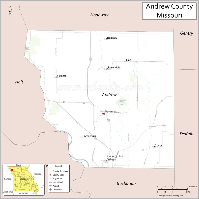
About Andrew County Map, Missouri: The map showing the county boundary, county seat, major cities, highways, water bodies and neighbouring counties.
Related Missouri Maps & Info
Andrew County, Missouri
Andrew County is a county located in the U.S. state of Missouri. It's county seat is Savannah. As per 2020 census, the population of Andrew County is 18002 people and population density is square miles. According to the United States Census Bureau, the county has a total area of 435 sq mi (1,127 km2). Andrew County was established on 1841.
Andrew County Facts
| Continent | North America |
| Country | United States |
| State | Missouri |
| County Seat | Savannah |
| Largest City/Town | Savannah |
| Established | 1841 |
| Total Area | 436 sq mi (1,129 sq km) |
| Land Area | 433 sq mi (1,121 sq km) |
| Water Area | 3 sq mi (8 sq km) |
| Population | 18,135 (Census 2020) |
| Population Density | 41.9 people per sq mi |
| Time Zone | Central Time Zone (CST/CDT) |
| Major Highways | Interstate 29, U.S. Route 59, U.S. Route 71 |
| Major Rivers | Missouri River nearby region, One Hundred and Two River |
| Neighboring Counties | Nodaway County, DeKalb County, Buchanan County, Holt County, Gentry County |
| Famous For | Historic northwest Missouri communities, agriculture, rural landscapes, and nearby St. Joseph access |
| Top Attractions | Andrew County Museum, Lewis and Clark historic region nearby, Savannah town square, and Mozingo Lake nearby area |
| Official Website | Official Website |
About Andrew County
Andrew County is located in northwestern Missouri in the central United States and was established in 1841. The county seat and largest city is Savannah. The county is known for its agricultural heritage, small-town communities, scenic countryside, and convenient access to the St. Joseph metropolitan region.
Cities and Towns in Andrew County, Missouri
| City/Town | Population (Census 2020) | Latitude & Longitude |
|---|---|---|
| Savannah (county seat) | 5,057 | 39.9419°N, 94.8291°W |
| Country Club Village | 8,552 | 39.9161°N, 94.8211°W |
| Rosendale | 123 | 40.0381°N, 94.8183°W |
| Amazonia | 312 | 39.8864°N, 94.8961°W |
| Fillmore | 174 | 40.0120°N, 94.9764°W |
| Helena | 61 | 39.9048°N, 94.6544°W |
What are the Golf Courses in Andrew County
| Golf Course | Location | Latitude & Longitude |
|---|---|---|
| Duncan Hills Golf Course | Savannah | 39.9487°N, 94.8360°W |
| Country Club Village Golf Recreation Area | Country Club Village | 39.9224°N, 94.8275°W |
Major Roads and Highways in Andrew County
Major highways connect the county with northwest Missouri communities and regional commercial centers.
- Interstate 29 - major north-south interstate through northwestern Missouri
- U.S. Route 59 - regional transportation corridor through rural communities
- U.S. Route 71 - important highway linking Missouri with Iowa and Kansas City
What are Neighboring Counties of Andrew County
- Nodaway County (north)
- Gentry County (east)
- DeKalb County (southeast)
- Buchanan County (south)
- Holt County (west)
What Are the Top Attractions in Andrew County
The county offers a mix of rural scenery, local history, and nearby recreation opportunities.
- Andrew County Museum - exhibits on pioneer settlement, agriculture, and local history
- Lewis and Clark Historic Region nearby - heritage sites connected to the expedition route
- Savannah Town Square - historic downtown area with shops and community events
- Mozingo Lake nearby area - boating, fishing, camping, and golf recreation destination
- Duncan Hills Golf Course - scenic golfing facility in the Savannah area
- Northwest Missouri Scenic Drives - rolling countryside and farmland landscapes
- One Hundred and Two River Valley - wildlife viewing and outdoor photography opportunities
- Historic Rural Churches and Schoolhouses - preserved architecture from early settlement years
- Community Festivals in Savannah - local fairs, parades, and seasonal celebrations
- Nearby St. Joseph Attractions - museums, shopping, and entertainment within short driving distance
What Is the Distance from Andrew County to Nearby Cities
The following distances are measured by road (driving).
- Savannah to St. Joseph (Buchanan County), Missouri - 12 mi (19 km)
- Savannah to Maryville (Nodaway County), Missouri - 44 mi (71 km)
- Savannah to Kansas City (Jackson County), Missouri - 64 mi (103 km)
- Savannah to Omaha (Douglas County), Nebraska - 112 mi (180 km)
- Savannah to Des Moines (Polk County), Iowa - 174 mi (280 km)
- Savannah to Country Club Village (Andrew County), Missouri - 3 mi (5 km)
- Savannah to Amazonia (Andrew County), Missouri - 8 mi (13 km)
- Savannah to Columbia (Boone County), Missouri - 175 mi (282 km)
- Savannah to Springfield (Greene County), Missouri - 233 mi (375 km)
- Savannah to Wichita (Sedgwick County), Kansas - 281 mi (452 km)
- Savannah to Saint Louis (St. Louis City), Missouri - 329 mi (529 km)
- Savannah to Minneapolis (Hennepin County), Minnesota - 440 mi (708 km)
- Savannah to Denver (Denver County), Colorado - 618 mi (995 km)
FAQs about Andrew County
Andrew County is located in northwestern Missouri near the Missouri River region.
Andrew County had a population of 18,135 according to the 2020 United States Census.
Andrew County is known for agriculture, rural landscapes, historic communities, and nearby access to St. Joseph.
The county is served by Interstate 29, U.S. Route 59, and U.S. Route 71.
Yes, Andrew County includes golf facilities such as Duncan Hills Golf Course and recreation areas near Country Club Village.
References
- QuickFacts - U.S. Census Bureau
- United States Census Bureau
- United States Geological Survey (USGS)
- National Geodetic Survey
- Official Website
- Adair County Map
- Andrew County Map
- Atchison County Map
- Audrain County Map
- Barry County Map
- Barton County Map
- Bates County Map
- Benton County Map
- Bollinger County Map
- Boone County Map
- Buchanan County Map
- Butler County Map
- Caldwell County Map
- Callaway County Map
- Camden County Map
- Cape Girardeau County Map
- Carroll County Map
- Carter County Map
- Cass County Map
- Cedar County Map
- Chariton County Map
- Christian County Map
- Clark County Map
- Clay County Map
- Clinton County Map
- Cole County Map
- Cooper County Map
- Crawford County Map
- Dade County Map
- Dallas County Map
- Daviess County Map
- DeKalb County Map
- Dent County Map
- Douglas County Map
- Dunklin County Map
- Franklin County Map
- Gasconade County Map
- Gentry County Map
- Greene County Map
- Grundy County Map
- Harrison County Map
- Henry County Map
- Hickory County Map
- Holt County Map
- Howard County Map
- Howell County Map
- Iron County Map
- Jackson County Map
- Jasper County Map
- Jefferson County Map
- Johnson County Map
- Knox County Map
- Laclede County Map
- Lafayette County Map
- Lawrence County Map
- Lewis County Map
- Lincoln County Map
- Linn County Map
- Livingston County Map
- McDonald County Map
- Macon County Map
- Madison County Map
- Maries County Map
- Marion County Map
- Mercer County Map
- Miller County Map
- Mississippi County Map
- Moniteau County Map
- Monroe County Map
- Montgomery County Map
- Morgan County Map
- New Madrid County Map
- Newton County Map
- Nodaway County Map
- Oregon County Map
- Osage County Map
- Ozark County Map
- Pemiscot County Map
- Perry County Map
- Pettis County Map
- Phelps County Map
- Pike County Map
- Platte County Map
- Polk County Map
- Pulaski County Map
- Putnam County Map
- Ralls County Map
- Randolph County Map
- Ray County Map
- Reynolds County Map
- Ripley County Map
- St Charles County Map
- St Clair County Map
- Ste Genevieve County Map
- St Francois County Map
- St Louis County Map
- Saline County Map
- Schuyler County Map
- Scotland County Map
- Scott County Map
- Shannon County Map
- Shelby County Map
- Stoddard County Map
- Stone County Map
- Sullivan County Map
- Taney County Map
- Texas County Map
- Vernon County Map
- Warren County Map
- Washington County Map
- Wayne County Map
- Webster County Map
- Worth County Map
- Wright County Map
- St Louis County Map
- Alabama Counties
- Alaska boroughs
- Arizona Counties
- Arkansas Counties
- California County Map
- Colorado Counties
- Connecticut Counties
- Delaware Counties
- Florida County Map
- Georgia County Map
- Hawaii Counties
- Idaho Counties
- Illinois Counties
- Indiana Counties
- Iowa Counties
- Kansas Counties
- Kentucky Counties
- Louisiana Counties
- Maine Counties
- Maryland Counties
- Massachusetts Counties
- Michigan County Map
- Minnesota Counties
- Mississippi Counties
- Missouri Counties
- Montana Counties
- Nebraska Counties
- Nevada Counties
- New York Counties
- New Hampshire Counties
- New Jersey Counties
- New Mexico Counties
- North Carolina Counties
- North Dakota Counties
- Ohio County Map
- Oklahoma Counties
- Oregon Counties
- Pennsylvania Counties
- Rhode Island Counties
- South Carolina Counties
- South Dakota Counties
- Map of Tennessee
- Texas County Map
- Utah Counties
- Vermont Counties
- Virginia Counties
- Washington Counties
- West Virginia Counties
- Wisconsin Counties
- Wyoming Counties