Map of Shelby County - Shelby County is a county located in the U.S. state of Missouri. Shelby County Map showing cities, highways, important places and water bodies. Get Where is Shelby County located in the map, major cities in Shelby county, population, areas, and places of interest.
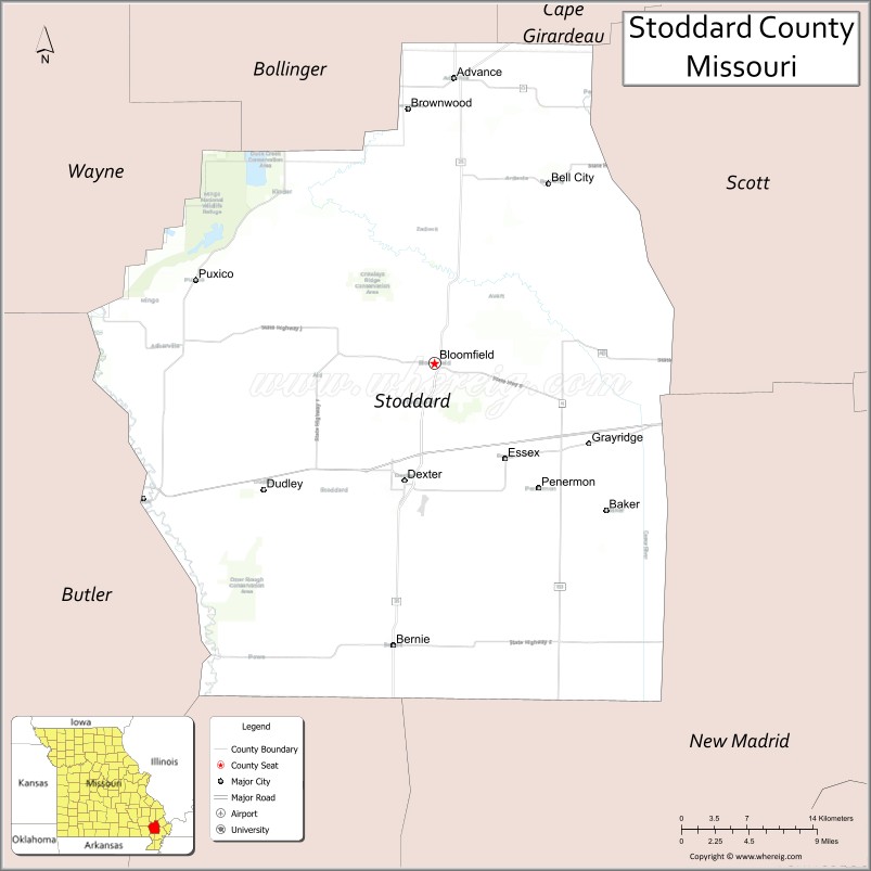
Map of Stoddard County, Missouri
About Shelby County Map, Missouri: The map showing the county boundary, county seat, major cities, highways, water bodies and neighbouring counties.
Related Missouri Maps & Info
Stoddard County, Missouri
Stoddard County is a county located in the U.S. state of Missouri. It's county seat is Bloomfield. As per 2020 census, the population of Stoddard County is 28479 people and population density is square miles. According to the United States Census Bureau, the county has a total area of 827 sq mi (2,142 km2). Stoddard County was established on 1835.
Stoddard County Facts
| Continent | North America |
| Country | United States |
| State | Missouri |
| County Seat | Bloomfield |
| Largest City/Town | Dexter |
| Established | 1835 |
| Total Area | 829 sq mi (2,147 sq km) |
| Land Area | 823 sq mi (2,131 sq km) |
| Water Area | 6 sq mi (16 sq km) |
| Population | 28,672 (Census 2020) |
| Population Density | 34.8 people per sq mi |
| Time Zone | Central Time Zone (CST/CDT) |
| Major Highways | U.S. Route 60, Missouri Route 25, Missouri Route 114, Missouri Route 91 |
| Major Rivers | St. Francis River, Castor River |
| Neighboring Counties | Bollinger County, Butler County, Scott County, Dunklin County, Wayne County |
| Famous For | Agriculture, Dexter barbecue traditions, Crowley's Ridge nearby region, and outdoor recreation |
| Top Attractions | Mingo National Wildlife Refuge, Dexter Welcome Center Depot Museum, Crowley's Ridge Conservation Area, and Wappapello Lake nearby region |
| Official Website | Official Website |
About Stoddard County
Stoddard County is located in southeastern Missouri within the Mississippi lowlands and Ozark transition region and was established in 1835. The county seat is Bloomfield, while Dexter is the largest city. The county is known for agriculture, outdoor recreation, wildlife areas, and small-town heritage.
Cities and Towns in Stoddard County, Missouri
| City/Town | Population (Census 2020) | Latitude & Longitude |
|---|---|---|
| Dexter | 7,927 | 36.7959°N, 89.9573°W |
| Bloomfield (county seat) | 1,933 | 36.8856°N, 89.9293°W |
| Puxico | 878 | 36.9501°N, 90.1590°W |
| Advance | 1,347 | 37.1048°N, 89.9106°W |
| Bernie | 1,681 | 36.6690°N, 89.9698°W |
| Essex | 472 | 36.8103°N, 89.7987°W |
What are the Golf Courses in Stoddard County
| Golf Course | Location | Latitude & Longitude |
|---|---|---|
| Hidden Trails Country Club | Dexter | 36.8094°N, 89.9718°W |
| Dexter Municipal Golf Course | Dexter | 36.7878°N, 89.9455°W |
| Bloomfield Recreation Golf Area | Bloomfield | 36.8963°N, 89.9427°W |
Major Roads and Highways in Stoddard County
Major highways connect Stoddard County with southeastern Missouri and regional agricultural communities.
- U.S. Route 60 - major east-west highway through southern Missouri
- Missouri Route 25 - important north-south route connecting Bootheel communities
- Missouri Route 114 - regional connector highway serving rural towns
- Missouri Route 91 - transportation route linking local communities and recreation areas
What are Neighboring Counties of Stoddard County
- Bollinger County (north)
- Wayne County (northwest)
- Scott County (east)
- Dunklin County (south)
- Butler County (west)
What Are the Top Attractions in Stoddard County
The county offers wildlife areas, parks, outdoor recreation, and local cultural attractions.
- Mingo National Wildlife Refuge - birdwatching, hiking, wetlands, and wildlife observation
- Dexter Welcome Center Depot Museum - railroad heritage and local history exhibits
- Crowley's Ridge Conservation Area - scenic nature trails and outdoor recreation
- Wappapello Lake nearby region - boating, fishing, camping, and swimming recreation
- Historic Downtown Dexter - shops, restaurants, and community events
- St. Francis River Recreation Areas - fishing and scenic outdoor activities
- Community Festivals and Barbecue Events - local traditions and seasonal celebrations
- Hunting and Wildlife Areas - deer hunting and nature observation opportunities
- Parks and Picnic Areas - family recreation and relaxation spaces
- Southeast Missouri Scenic Drives - farmland and countryside photography opportunities
What Is the Distance from Stoddard County to Nearby Cities
The following distances are measured by road (driving).
- Dexter to Poplar Bluff (Butler County), Missouri - 29 mi (47 km)
- Dexter to Cape Girardeau (Cape Girardeau County), Missouri - 66 mi (106 km)
- Dexter to Sikeston (Scott County), Missouri - 32 mi (51 km)
- Dexter to Jonesboro (Craighead County), Arkansas - 95 mi (153 km)
- Dexter to Bloomfield (Stoddard County), Missouri - 10 mi (16 km)
- Dexter to Bernie (Stoddard County), Missouri - 13 mi (21 km)
- Dexter to Springfield (Greene County), Missouri - 206 mi (332 km)
- Dexter to St. Louis (St. Louis City), Missouri - 167 mi (269 km)
- Dexter to Memphis (Shelby County), Tennessee - 171 mi (275 km)
- Dexter to Little Rock (Pulaski County), Arkansas - 190 mi (306 km)
- Dexter to Nashville (Davidson County), Tennessee - 263 mi (423 km)
- Dexter to Dallas (Dallas County), Texas - 488 mi (785 km)
- Dexter to Denver (Denver County), Colorado - 890 mi (1,432 km)
FAQs about Stoddard County
Stoddard County is located in southeastern Missouri within the Mississippi lowlands region.
Stoddard County had a population of 28,672 according to the 2020 United States Census.
Stoddard County is known for agriculture, outdoor recreation, wildlife areas, and Dexter barbecue traditions.
The county is served by U.S. Route 60, Missouri Route 25, Missouri Route 114, and Missouri Route 91.
Yes, Stoddard County includes golf facilities such as Hidden Trails Country Club and Dexter Municipal Golf Course.
References
- QuickFacts - U.S. Census Bureau
- United States Census Bureau
- United States Geological Survey (USGS)
- National Geodetic Survey
- Official Website
- Adair County Map
- Andrew County Map
- Atchison County Map
- Audrain County Map
- Barry County Map
- Barton County Map
- Bates County Map
- Benton County Map
- Bollinger County Map
- Boone County Map
- Buchanan County Map
- Butler County Map
- Caldwell County Map
- Callaway County Map
- Camden County Map
- Cape Girardeau County Map
- Carroll County Map
- Carter County Map
- Cass County Map
- Cedar County Map
- Chariton County Map
- Christian County Map
- Clark County Map
- Clay County Map
- Clinton County Map
- Cole County Map
- Cooper County Map
- Crawford County Map
- Dade County Map
- Dallas County Map
- Daviess County Map
- DeKalb County Map
- Dent County Map
- Douglas County Map
- Dunklin County Map
- Franklin County Map
- Gasconade County Map
- Gentry County Map
- Greene County Map
- Grundy County Map
- Harrison County Map
- Henry County Map
- Hickory County Map
- Holt County Map
- Howard County Map
- Howell County Map
- Iron County Map
- Jackson County Map
- Jasper County Map
- Jefferson County Map
- Johnson County Map
- Knox County Map
- Laclede County Map
- Lafayette County Map
- Lawrence County Map
- Lewis County Map
- Lincoln County Map
- Linn County Map
- Livingston County Map
- McDonald County Map
- Macon County Map
- Madison County Map
- Maries County Map
- Marion County Map
- Mercer County Map
- Miller County Map
- Mississippi County Map
- Moniteau County Map
- Monroe County Map
- Montgomery County Map
- Morgan County Map
- New Madrid County Map
- Newton County Map
- Nodaway County Map
- Oregon County Map
- Osage County Map
- Ozark County Map
- Pemiscot County Map
- Perry County Map
- Pettis County Map
- Phelps County Map
- Pike County Map
- Platte County Map
- Polk County Map
- Pulaski County Map
- Putnam County Map
- Ralls County Map
- Randolph County Map
- Ray County Map
- Reynolds County Map
- Ripley County Map
- St Charles County Map
- St Clair County Map
- Ste Genevieve County Map
- St Francois County Map
- St Louis County Map
- Saline County Map
- Schuyler County Map
- Scotland County Map
- Scott County Map
- Shannon County Map
- Shelby County Map
- Stoddard County Map
- Stone County Map
- Sullivan County Map
- Taney County Map
- Texas County Map
- Vernon County Map
- Warren County Map
- Washington County Map
- Wayne County Map
- Webster County Map
- Worth County Map
- Wright County Map
- St Louis County Map
- Alabama Counties
- Alaska boroughs
- Arizona Counties
- Arkansas Counties
- California County Map
- Colorado Counties
- Connecticut Counties
- Delaware Counties
- Florida County Map
- Georgia County Map
- Hawaii Counties
- Idaho Counties
- Illinois Counties
- Indiana Counties
- Iowa Counties
- Kansas Counties
- Kentucky Counties
- Louisiana Counties
- Maine Counties
- Maryland Counties
- Massachusetts Counties
- Michigan County Map
- Minnesota Counties
- Mississippi Counties
- Missouri Counties
- Montana Counties
- Nebraska Counties
- Nevada Counties
- New York Counties
- New Hampshire Counties
- New Jersey Counties
- New Mexico Counties
- North Carolina Counties
- North Dakota Counties
- Ohio County Map
- Oklahoma Counties
- Oregon Counties
- Pennsylvania Counties
- Rhode Island Counties
- South Carolina Counties
- South Dakota Counties
- Map of Tennessee
- Texas County Map
- Utah Counties
- Vermont Counties
- Virginia Counties
- Washington Counties
- West Virginia Counties
- Wisconsin Counties
- Wyoming Counties