Map of Douglas County - Douglas County is a county located in the U.S. state of Missouri. Douglas County Map showing cities, highways, important places and water bodies. Get Where is Douglas County located in the map, major cities in Douglas county, population, areas, and places of interest.
Map of Douglas County, Missouri
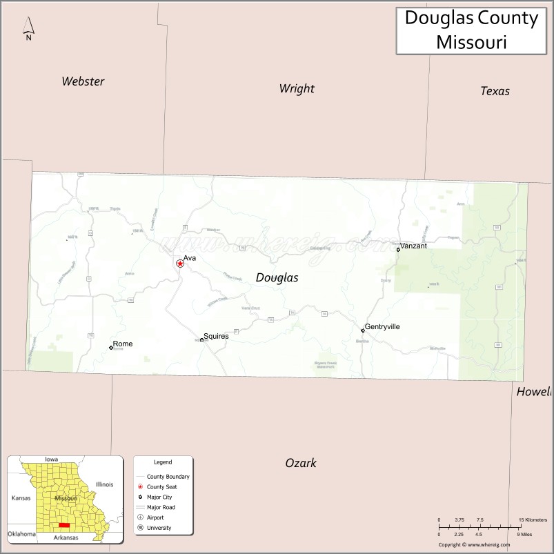
About Douglas County Map, Missouri: The map showing the county boundary, county seat, major cities, highways, water bodies and neighbouring counties.
Related Missouri Maps & Info
Douglas County, Missouri
Douglas County is a county located in the U.S. state of Missouri. It's county seat is Ava. As per 2020 census, the population of Douglas County is 11732 people and population density is square miles. According to the United States Census Bureau, the county has a total area of 815 sq mi (2,111 km2). Douglas County was established on 1857.
Douglas County Facts
| Continent | North America |
| Country | United States |
| State | Missouri |
| County Seat | Ava |
| Largest City/Town | Ava |
| Established | 1857 |
| Total Area | 815 sq mi (2,111 sq km) |
| Land Area | 814 sq mi (2,108 sq km) |
| Water Area | 1 sq mi (3 sq km) |
| Population | 11,578 (Census 2020) |
| Population Density | 14.2 people per sq mi |
| Time Zone | Central Time Zone (CST/CDT) |
| Major Highways | U.S. Route 5, Missouri Route 14, Missouri Route 76, Missouri Route 181 |
| Major Rivers | Bryant Creek, North Fork River nearby region |
| Neighboring Counties | Wright County, Texas County, Howell County, Ozark County, Christian County, Webster County |
| Famous For | Ozark mountains, cattle ranching, scenic countryside, and outdoor recreation |
| Top Attractions | Glade Top Trail Scenic Byway, Bryant Creek, Mark Twain National Forest, and Ava historic square |
| Official Website | Official Website |
About Douglas County
Douglas County is located in southern Missouri in the Ozarks region and was established in 1857. The county seat and largest city is Ava. The county is known for scenic mountain ridges, ranching traditions, forests, streams, and outdoor recreation opportunities throughout the Ozark Highlands.
Cities and Towns in Douglas County, Missouri
| City/Town | Population (Census 2020) | Latitude & Longitude |
|---|---|---|
| Ava (county seat) | 2,993 | 36.9520°N, 92.6604°W |
| Foster nearby area | 154 | 36.8458°N, 92.5256°W |
| Rome nearby area | 102 | 36.7762°N, 92.5660°W |
| Squires nearby area | 87 | 36.8450°N, 92.7682°W |
| Vanzant nearby area | 56 | 37.1169°N, 92.2435°W |
| Gentryville nearby area | 44 | 36.9970°N, 92.7908°W |
What are the Golf Courses in Douglas County
| Golf Course | Location | Latitude & Longitude |
|---|---|---|
| Ava Country Club Golf Course | Ava | 36.9582°N, 92.6688°W |
| Ozark Ridge Golf Recreation Area | Ava nearby region | 36.9445°N, 92.6511°W |
Major Roads and Highways in Douglas County
Major highways connect the county with southern Missouri communities and scenic Ozark recreation regions.
- U.S. Route 5 - important north-south route through the Ozarks
- Missouri Route 14 - east-west highway connecting Ava and nearby towns
- Missouri Route 76 - scenic transportation route through forested countryside
- Missouri Route 181 - regional highway serving rural communities and recreation areas
What are Neighboring Counties of Douglas County
- Wright County (north)
- Texas County (northeast)
- Howell County (east)
- Ozark County (south)
- Christian County (west)
- Webster County (northwest)
What Are the Top Attractions in Douglas County
The county offers scenic mountain landscapes, forests, streams, and outdoor recreation throughout the Ozarks.
- Glade Top Trail Scenic Byway - panoramic ridge-top driving route with Ozark mountain views
- Bryant Creek Recreation Areas - fishing, canoeing, swimming, and camping opportunities
- Mark Twain National Forest - hiking, horseback riding, camping, and wildlife viewing
- Ava Historic Square - local shops, restaurants, and historic courthouse attractions
- North Fork River nearby region - floating, kayaking, and trout fishing destinations
- Ozark Mountain Scenic Drives - rolling hills, forests, and countryside overlooks
- Caney Mountain Conservation Area nearby area - wildlife observation and hiking trails
- Douglas County Museum - exhibits on local ranching and pioneer history
- Camping and Hunting Areas - outdoor recreation throughout forest and prairie regions
- Community Festivals and Rodeos - celebrations of Ozark culture and ranching heritage
What Is the Distance from Douglas County to Nearby Cities
The following distances are measured by road (driving).
- Ava to Springfield (Greene County), Missouri - 57 mi (92 km)
- Ava to Branson (Taney County), Missouri - 62 mi (100 km)
- Ava to West Plains (Howell County), Missouri - 63 mi (101 km)
- Ava to Mountain Home (Baxter County), Arkansas - 79 mi (127 km)
- Ava to Foster nearby area - 10 mi (16 km)
- Ava to Rome nearby area - 17 mi (27 km)
- Ava to Jefferson City (Cole County), Missouri - 170 mi (274 km)
- Ava to Kansas City (Jackson County), Missouri - 238 mi (383 km)
- Ava to Saint Louis (St. Louis City), Missouri - 243 mi (391 km)
- Ava to Tulsa (Tulsa County), Oklahoma - 229 mi (369 km)
- Ava to Little Rock (Pulaski County), Arkansas - 182 mi (293 km)
- Ava to Chicago (Cook County), Illinois - 553 mi (890 km)
- Ava to Denver (Denver County), Colorado - 736 mi (1,184 km)
FAQs about Douglas County
Douglas County is located in southern Missouri in the Ozarks region.
Douglas County had a population of 11,578 according to the 2020 United States Census.
Douglas County is known for Ozark mountain scenery, ranching, forests, and outdoor recreation.
The county is served by U.S. Route 5, Missouri Route 14, Missouri Route 76, and Missouri Route 181.
Yes, Douglas County includes golf facilities such as Ava Country Club Golf Course and Ozark Ridge Golf Recreation Area.
References
- QuickFacts - U.S. Census Bureau
- United States Census Bureau
- United States Geological Survey (USGS)
- National Geodetic Survey
- Official Website
- Adair County Map
- Andrew County Map
- Atchison County Map
- Audrain County Map
- Barry County Map
- Barton County Map
- Bates County Map
- Benton County Map
- Bollinger County Map
- Boone County Map
- Buchanan County Map
- Butler County Map
- Caldwell County Map
- Callaway County Map
- Camden County Map
- Cape Girardeau County Map
- Carroll County Map
- Carter County Map
- Cass County Map
- Cedar County Map
- Chariton County Map
- Christian County Map
- Clark County Map
- Clay County Map
- Clinton County Map
- Cole County Map
- Cooper County Map
- Crawford County Map
- Dade County Map
- Dallas County Map
- Daviess County Map
- DeKalb County Map
- Dent County Map
- Douglas County Map
- Dunklin County Map
- Franklin County Map
- Gasconade County Map
- Gentry County Map
- Greene County Map
- Grundy County Map
- Harrison County Map
- Henry County Map
- Hickory County Map
- Holt County Map
- Howard County Map
- Howell County Map
- Iron County Map
- Jackson County Map
- Jasper County Map
- Jefferson County Map
- Johnson County Map
- Knox County Map
- Laclede County Map
- Lafayette County Map
- Lawrence County Map
- Lewis County Map
- Lincoln County Map
- Linn County Map
- Livingston County Map
- McDonald County Map
- Macon County Map
- Madison County Map
- Maries County Map
- Marion County Map
- Mercer County Map
- Miller County Map
- Mississippi County Map
- Moniteau County Map
- Monroe County Map
- Montgomery County Map
- Morgan County Map
- New Madrid County Map
- Newton County Map
- Nodaway County Map
- Oregon County Map
- Osage County Map
- Ozark County Map
- Pemiscot County Map
- Perry County Map
- Pettis County Map
- Phelps County Map
- Pike County Map
- Platte County Map
- Polk County Map
- Pulaski County Map
- Putnam County Map
- Ralls County Map
- Randolph County Map
- Ray County Map
- Reynolds County Map
- Ripley County Map
- St Charles County Map
- St Clair County Map
- Ste Genevieve County Map
- St Francois County Map
- St Louis County Map
- Saline County Map
- Schuyler County Map
- Scotland County Map
- Scott County Map
- Shannon County Map
- Shelby County Map
- Stoddard County Map
- Stone County Map
- Sullivan County Map
- Taney County Map
- Texas County Map
- Vernon County Map
- Warren County Map
- Washington County Map
- Wayne County Map
- Webster County Map
- Worth County Map
- Wright County Map
- St Louis County Map
- Alabama Counties
- Alaska boroughs
- Arizona Counties
- Arkansas Counties
- California County Map
- Colorado Counties
- Connecticut Counties
- Delaware Counties
- Florida County Map
- Georgia County Map
- Hawaii Counties
- Idaho Counties
- Illinois Counties
- Indiana Counties
- Iowa Counties
- Kansas Counties
- Kentucky Counties
- Louisiana Counties
- Maine Counties
- Maryland Counties
- Massachusetts Counties
- Michigan County Map
- Minnesota Counties
- Mississippi Counties
- Missouri Counties
- Montana Counties
- Nebraska Counties
- Nevada Counties
- New York Counties
- New Hampshire Counties
- New Jersey Counties
- New Mexico Counties
- North Carolina Counties
- North Dakota Counties
- Ohio County Map
- Oklahoma Counties
- Oregon Counties
- Pennsylvania Counties
- Rhode Island Counties
- South Carolina Counties
- South Dakota Counties
- Map of Tennessee
- Texas County Map
- Utah Counties
- Vermont Counties
- Virginia Counties
- Washington Counties
- West Virginia Counties
- Wisconsin Counties
- Wyoming Counties