Map of Wayne County - Wayne County is a county located in the U.S. state of Missouri. Wayne County Map showing cities, highways, important places and water bodies. Get Where is Wayne County located in the map, major cities in Wayne county, population, areas, and places of interest.
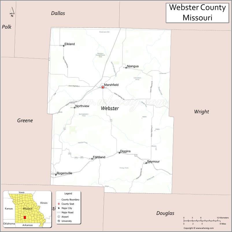
Map of Webster County, Missouri
About Wayne County Map, Missouri: The map showing the county boundary, county seat, major cities, highways, water bodies and neighbouring counties.
Related Missouri Maps & Info
Webster County, Missouri
Webster County is a county located in the U.S. state of Missouri. It's county seat is Marshfield. As per 2020 census, the population of Webster County is 39735 people and population density is square miles. According to the United States Census Bureau, the county has a total area of 593 sq mi (1,536 km2). Webster County was established on 1855.
Webster County Facts
| Continent | North America |
| Country | United States |
| State | Missouri |
| County Seat | Marshfield |
| Largest City/Town | Marshfield |
| Established | 1855 |
| Total Area | 593 sq mi (1,536 sq km) |
| Land Area | 593 sq mi (1,536 sq km) |
| Water Area | 0.1 sq mi (0.3 sq km) |
| Population | 39,085 (Census 2020) |
| Population Density | 65.9 people per sq mi |
| Time Zone | Central Time Zone (CST/CDT) |
| Major Highways | Interstate 44, U.S. Route 60, Missouri Route 13, Missouri Route CC |
| Major Rivers | Niangua River, Gasconade River nearby region |
| Neighboring Counties | Greene County, Dallas County, Wright County, Laclede County, Christian County |
| Famous For | Ozark scenery, Marshfield, outdoor recreation, and historic Route 66 nearby region |
| Top Attractions | Bennett Spring State Park nearby region, Route 66 attractions, Niangua River recreation, and Webster County Courthouse |
| Official Website | Official Website |
About Webster County
Webster County is located in southwestern Missouri within the Ozark Plateau and was established in 1855. The county seat and largest city is Marshfield. The county is known for scenic countryside, rivers, outdoor recreation, and easy access to the Springfield metropolitan region.
Cities and Towns in Webster County, Missouri
| City/Town | Population (Census 2020) | Latitude & Longitude |
|---|---|---|
| Marshfield (county seat) | 7,458 | 37.3389°N, 92.9071°W |
| Rogersville | 3,897 | 37.1201°N, 93.0552°W |
| Seymour | 1,921 | 37.1467°N, 92.7688°W |
| Fordland | 914 | 37.1537°N, 92.9421°W |
| Niangua | 445 | 37.3871°N, 92.8282°W |
| Strafford nearby region | 2,543 | 37.2681°N, 93.1171°W |
What are the Golf Courses in Webster County
| Golf Course | Location | Latitude & Longitude |
|---|---|---|
| Marshfield Country Club | Marshfield | 37.3475°N, 92.9193°W |
| Hidden Valley Golf Links | Rogersville | 37.1287°N, 93.0679°W |
| Seymour Golf and Recreation Area | Seymour | 37.1594°N, 92.7798°W |
Major Roads and Highways in Webster County
Major highways connect Webster County with Springfield, central Missouri, and Ozark recreation regions.
- Interstate 44 - major east-west interstate corridor across Missouri
- U.S. Route 60 - important regional highway serving southern Missouri
- Missouri Route 13 - north-south transportation route through the Ozarks
- Missouri Route CC - connector serving rural communities and recreation areas
What are Neighboring Counties of Webster County
- Greene County (west)
- Christian County (southwest)
- Dallas County (north)
- Laclede County (northeast)
- Wright County (east)
What Are the Top Attractions in Webster County
The county offers rivers, scenic countryside, parks, and outdoor recreation opportunities.
- Niangua River Recreation Areas - canoeing, kayaking, fishing, and camping
- Bennett Spring State Park nearby region - trout fishing and hiking trails
- Historic Route 66 nearby region - classic roadside attractions and scenic driving
- Webster County Courthouse - historic county landmark in Marshfield
- Marshfield Town Square - shops, restaurants, and community events
- Ozark Scenic Drives - rolling hills and countryside photography opportunities
- Community Festivals and Heritage Events - seasonal entertainment and local traditions
- Hunting and Wildlife Areas - outdoor recreation and nature observation
- Camping and RV Parks - family outdoor recreation facilities
- Nature Trails and Parks - hiking, relaxation, and environmental exploration
What Is the Distance from Webster County to Nearby Cities
The following distances are measured by road (driving).
- Marshfield to Springfield (Greene County), Missouri - 24 mi (39 km)
- Marshfield to Lebanon (Laclede County), Missouri - 37 mi (60 km)
- Marshfield to Branson (Taney County), Missouri - 63 mi (101 km)
- Marshfield to Rolla (Phelps County), Missouri - 89 mi (143 km)
- Marshfield to Rogersville (Webster County), Missouri - 16 mi (26 km)
- Marshfield to Seymour (Webster County), Missouri - 25 mi (40 km)
- Marshfield to Kansas City (Jackson County), Missouri - 189 mi (304 km)
- Marshfield to St. Louis (St. Louis City), Missouri - 208 mi (335 km)
- Marshfield to Tulsa (Tulsa County), Oklahoma - 179 mi (288 km)
- Marshfield to Little Rock (Pulaski County), Arkansas - 221 mi (356 km)
- Marshfield to Dallas (Dallas County), Texas - 455 mi (732 km)
- Marshfield to Chicago (Cook County), Illinois - 485 mi (781 km)
- Marshfield to Denver (Denver County), Colorado - 694 mi (1,117 km)
FAQs about Webster County
Webster County is located in southwestern Missouri within the Ozark Plateau.
Webster County had a population of 39,085 according to the 2020 United States Census.
Webster County is known for Ozark scenery, rivers, outdoor recreation, and historic Route 66 nearby attractions.
The county is served by Interstate 44, U.S. Route 60, Missouri Route 13, and Missouri Route CC.
Yes, Webster County includes golf facilities such as Marshfield Country Club and Hidden Valley Golf Links.
References
- QuickFacts - U.S. Census Bureau
- United States Census Bureau
- United States Geological Survey (USGS)
- National Geodetic Survey
- Official Website
- Adair County Map
- Andrew County Map
- Atchison County Map
- Audrain County Map
- Barry County Map
- Barton County Map
- Bates County Map
- Benton County Map
- Bollinger County Map
- Boone County Map
- Buchanan County Map
- Butler County Map
- Caldwell County Map
- Callaway County Map
- Camden County Map
- Cape Girardeau County Map
- Carroll County Map
- Carter County Map
- Cass County Map
- Cedar County Map
- Chariton County Map
- Christian County Map
- Clark County Map
- Clay County Map
- Clinton County Map
- Cole County Map
- Cooper County Map
- Crawford County Map
- Dade County Map
- Dallas County Map
- Daviess County Map
- DeKalb County Map
- Dent County Map
- Douglas County Map
- Dunklin County Map
- Franklin County Map
- Gasconade County Map
- Gentry County Map
- Greene County Map
- Grundy County Map
- Harrison County Map
- Henry County Map
- Hickory County Map
- Holt County Map
- Howard County Map
- Howell County Map
- Iron County Map
- Jackson County Map
- Jasper County Map
- Jefferson County Map
- Johnson County Map
- Knox County Map
- Laclede County Map
- Lafayette County Map
- Lawrence County Map
- Lewis County Map
- Lincoln County Map
- Linn County Map
- Livingston County Map
- McDonald County Map
- Macon County Map
- Madison County Map
- Maries County Map
- Marion County Map
- Mercer County Map
- Miller County Map
- Mississippi County Map
- Moniteau County Map
- Monroe County Map
- Montgomery County Map
- Morgan County Map
- New Madrid County Map
- Newton County Map
- Nodaway County Map
- Oregon County Map
- Osage County Map
- Ozark County Map
- Pemiscot County Map
- Perry County Map
- Pettis County Map
- Phelps County Map
- Pike County Map
- Platte County Map
- Polk County Map
- Pulaski County Map
- Putnam County Map
- Ralls County Map
- Randolph County Map
- Ray County Map
- Reynolds County Map
- Ripley County Map
- St Charles County Map
- St Clair County Map
- Ste Genevieve County Map
- St Francois County Map
- St Louis County Map
- Saline County Map
- Schuyler County Map
- Scotland County Map
- Scott County Map
- Shannon County Map
- Shelby County Map
- Stoddard County Map
- Stone County Map
- Sullivan County Map
- Taney County Map
- Texas County Map
- Vernon County Map
- Warren County Map
- Washington County Map
- Wayne County Map
- Webster County Map
- Worth County Map
- Wright County Map
- St Louis County Map
- Alabama Counties
- Alaska boroughs
- Arizona Counties
- Arkansas Counties
- California County Map
- Colorado Counties
- Connecticut Counties
- Delaware Counties
- Florida County Map
- Georgia County Map
- Hawaii Counties
- Idaho Counties
- Illinois Counties
- Indiana Counties
- Iowa Counties
- Kansas Counties
- Kentucky Counties
- Louisiana Counties
- Maine Counties
- Maryland Counties
- Massachusetts Counties
- Michigan County Map
- Minnesota Counties
- Mississippi Counties
- Missouri Counties
- Montana Counties
- Nebraska Counties
- Nevada Counties
- New York Counties
- New Hampshire Counties
- New Jersey Counties
- New Mexico Counties
- North Carolina Counties
- North Dakota Counties
- Ohio County Map
- Oklahoma Counties
- Oregon Counties
- Pennsylvania Counties
- Rhode Island Counties
- South Carolina Counties
- South Dakota Counties
- Map of Tennessee
- Texas County Map
- Utah Counties
- Vermont Counties
- Virginia Counties
- Washington Counties
- West Virginia Counties
- Wisconsin Counties
- Wyoming Counties